Tag:man_made=video_wall
| Description |
|---|
| A digital screen, typically constructed out of smaller LED panels. |
| Group: man made |
| Used on these elements |
| Status: approved |
| Tools for this tag |
|
A ![]() Video wall (also called an LED Wall) is a digital screen, typically constructed out of smaller
Video wall (also called an LED Wall) is a digital screen, typically constructed out of smaller ![]() LED panels. Digital screens are used to show video, film, TV, camera feeds, advertising content, or other digital content. They are especially common at large events, and at events venues like stadiums and outdoor cinemas.
LED panels. Digital screens are used to show video, film, TV, camera feeds, advertising content, or other digital content. They are especially common at large events, and at events venues like stadiums and outdoor cinemas.
How to map
Draw a ![]() Node or a
Node or a ![]() Way, and tag it as man_made=video_wall. A Way is more useful to 3D rendering software.
Way, and tag it as man_made=video_wall. A Way is more useful to 3D rendering software.
Keep in mind Good Practice: do not map LED walls set up temporarily for an event.
Notes:
- You may combine man_made=video_wall with barrier=wall only if the LED wall sits on the ground and therefore acts as a barrier. See the examples section below
- You may combine man_made=video_wall with advertising=screen if its sole purpose is to show advertising material.
- For double sided screens, you can add sides=2. By default, sides=1 is implied.
Other useful tags to use in combination are support=*, operator=*, height=*, min_height=* (see examples below)
Examples
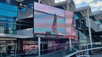
An LED wall supported by two poles. Use man_made=video_wall + support=pole
A LED display used as a scoreboard. Use man_made=video_wall
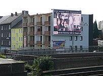
An LED wall on the side of a building. Use man_made=video_wall + support=wall_mounted
- ↑ Technically the screen is hanging off the truss, but is nevertheless sitting at ground level
- ↑ Keep in mind Good Practice: do not map LED walls set up temporarily for an event
Special Cases
A screen used purely for advertising. Use man_made=video_wall + advertising=screen (+ support=wall_mounted)
A screen used as an outdoor cinema. Map the screen with man_made=video_wall. Also map the whole cinema using a
 Node or
  Area tagged with amenity=cinema
Height
Use the tags height=* and min_height=* to map the height of the screen. See the page min_height=* for a good explanation of how to use tags
The screen is 4 metres high, the pole is 3 metres high. Thus, height=7 and min_height=3
See also
- screen=* - used on venues (like amenity=cinema) to state how many screens are located inside.
- advertising=*


![An LED wall sitting on ground[note 1]. Use man_made=video_wall + support=ground + barrier=wall](/w/images/thumb/f/fd/Led_wall_on_ground.jpg/250px-Led_wall_on_ground.jpg)

![An LED wall on top of a fold-out container.[note 2] Use man_made=video_wall + support=roof, also map the container as building=container](/w/images/thumb/1/17/Led_wall_on_container.jpg/250px-Led_wall_on_container.jpg)
