Tag:police=naval_base
Jump to navigation
Jump to search
| Description |
|---|
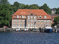
| A police station with pier for the naval, river or maritime police. |
| Group: police |
| Used on these elements |
| Useful combination |
|
| Status: approved |
| Tools for this tag |
|
A police station with pier for the naval, river or maritime police.
How to map
Draw the outline of the building or the area occupied by the naval, maritime or river police station. This typically includes a police station and a pier where police boats can dock. In maritime ports this may be bigger facilities for the coast guard.
Before mapping, be careful to find out first if a maritime protection unit is a police or a military unit.
