Tag:sport=cricket_nets
Jump to navigation
Jump to search
 |
| Description |
|---|
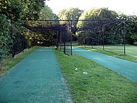
| An area bounded by netting, used to practise batting and bowling for the sport of cricket and to enable smaller groups to play. |
| Group: sports |
| Used on these elements |
| Status: in use |
| Tools for this tag |
|
Cricket nets are an area, bounded by netting, often at the side of cricket pitches, used to practise batting and bowling for the sport of cricket, and enable smaller groups to play when a full game is not possible.
How to map
sport=cricket_nets- A node, or closed polygon to indicated the area of the nets.surface=*- To indicate the surface construction of the area. Often artificial as grass would quickly wear out from constant use.
Problem
It is one of counterintuitive keys, "cricket nets" is not a separate sport. You may use leisure=practice_pitch + sport=cricket instead.