Tag:tunnel=canal
Jump to navigation
Jump to search
| Description |
|---|
| Tunnel for navigable canals |
| Rendering in OSM Carto |

|
| Group: waterways |
| Used on these elements |
| Useful combination |
| Status: in use |
| Tools for this tag |
|
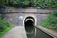
Tunnel for navigable canals.
The maximum clearance of ships is specified with maxheight=* maxwidth=* and draft=*
For a towing path that runs alongside use towpath=yes
This value is only for underground shipping canals. For other waterway=*s that run underground consider tunnel=flooded or tunnel=culvert
