INT 1
#
|
Symbol
|
Description
|
OSM Tags
|
OSM Proposals
|
H: Tides, Currents
|
| H1
|
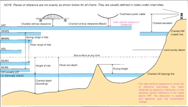
CD
|
Datum for Sounding Reduction
|
|
This information should be kept in a separate database
|
| H2
|
LAT
|
Lowest Astronomical Tide (LAT)
|
|
This information should be kept in a separate database
|
| H3
|
HAT
|
Highest Astronomical Tide (HAT)
|
|
This information should be kept in a separate database
|
| H4
|
MLW
|
Mean Low Water (MLW)
|
|
This information should be kept in a separate database
|
| H5
|
MHW
|
Mean High Water (MHW)
|
|
This information should be kept in a separate database
|
| H6
|
MSL
|
Mean Sea Level (MSL)
|
|
This information should be kept in a separate database
|
| H7
|
|
Land Survey Datum
|
|
This information should be kept in a separate database
|
| H8
|
MLWS
|
Mean Low Water Spring (MLWS)
|
|
This information should be kept in a separate database
|
| H9
|
MHWS
|
Mean High Water Spring (MHWS)
|
|
This information should be kept in a separate database
|
| H10
|
MLWN
|
Mean Low Water Neap (MLWN)
|
|
This information should be kept in a separate database
|
| H11
|
MHWN
|
Mean High Water Neap (MHWN)
|
|
This information should be kept in a separate database
|
| H12
|
MLLW
|
Mean Lower Low Water (MLLW)
|
|
This information should be kept in a separate database
|
| H13
|
MHHW
|
Mean Higher High Water (MHHW)
|
|
This information should be kept in a separate database
|
| H14
|
MHLW
|
Mean Higher Low Water (MHLW)
|
|
This information should be kept in a separate database
|
| H15
|
MLHW
|
Mean Lower High Water (MLHW)
|
|
This information should be kept in a separate database
|
| H16
|
Sp
|
Spring Tide (Sp)
|
|
This information should be kept in a separate database
|
| H17
|
Np
|
Neap Tide (Np)
|
|
This information should be kept in a separate database
|
| H20
|
References

|
| H30
|
Semi-Diurnal and Diurnal Tide Level

|
| H31
|
Tidal streams table

|
| H40
|

|
Tidal Stream Arrow
|
|
This information should be kept in a separate database
|
| H41
|

|
Tidal Stream Arrow
|
|
This information should be kept in a separate database
|
| H42
|

|
Non-tidal current in restricted waters
|
|
This information should be kept in a separate database
|
| H43
|

|
Non-tidal or ocean current in restricted waters
|
|
This information should be kept in a separate database
|
| H44
|

|
Overfalls, races, and tide rips
|
|
This information should be kept in a separate database
|
| H45
|

|
Eddie
|
|
This information should be kept in a separate database
|
| H46
|

|
Locations, often referred to as diamonds due to its shape, are locations of reference for tidal and current diagrams
|
|
This information should be kept in a separate database
|
| H47
|

|
Offshore positionfor which tidal levels are tabulated
|
|
This information should be kept in a separate database
|
National variations starts here
|
 Ha Ha
|
HW
|
High Water
|
|
|
 Hb Hb
|
LW
|
Low Water
|
|
|
 Hc Hc
|
MTL
|
Mean Tide Level
|
|
|
 Hd Hd
|
OD
|
Ordinance Datum
|
|
This is of no interest as all positions in OSM refere to WGS84
|
 He He
|

|
Wave Recorder
|
|
|
 Hf Hf
|

|
Current meter
|
|
|