UK 2016 Q1 Project: Schools
|
The Q1 2016 quarterly project is on Schools Please add #OSMschools to your changeset comment so that we can track our progress. |
The first UK Quarterly Project for 2016 is Schools.
There are two strands to this project. The first is to remotely (armchair) map and get an increase in coverage of the number of schools. The second strand is for those who prefer surveying: existing school names change (e.g change to Academy Status, amalgamations); there will schools in OSM with no name, and with the advent of free schools, new ones will be appearing constantly.
So there's plenty to do over the next few months!
For more info see the kick off mailing list post.
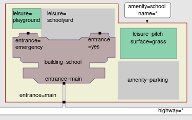
Suggested process & tags
Draw and tag the boundary polygon with a minimum of:
Add as many of these additional tags as you can / want to:
- one of:
- ref:edubase=* (England, Wales, oddities; see [1])
- ref:seedcode=* (Scotland; see [2])
- ref:estyn=* (Wales; see [3])
- ref:deniirn=* (Northern Ireland; see [4])
- wikidata=*
- website=*
- isced:level=*
Optionally, but preferably, draw the school buildings and tag:
Finally add entrances:
Resources

- Official schools data:
- Reports:
- Comparison tool (OSM progress against official data for England, Wales, Scotland, and Northern Ireland). See notes.
- Report on tags applied to amenity=school features.
- Maps:
- umap instance showing school points within a school polygon.
- ITO World map of schools with and without a name tag.
- Mapzen map of schools mapped only as a node.
- Other
- We have a MapRoulette task which is ideal if you're struggling to find schools to map. It automatically selects a random school for you!
- Dataset of amenity=school nodes within an amenity=school polygon (likely errors), polygon within polygon (likely errors), and amenity=school features within 100m of other schools (worth checking for errors). For more info see Frederik's initial email.
- amenity=school tag documentation. Also see Education features
- Wikipedia's list of schools in England - For comparison use only - remember don't import geodata from wikipedia (see Collaboration_with_Wikipedia)
Progress trackers
- School Edit tracker counts creations and modifications of nodes/ways with the amenity=school tag (not using #OSMSchool hashtag). Includes user rankings over all time + daily & hourly
- Daily report of amenity=school features as measured by TagInfo UK.
- The comparison tool (as above) also features as a progress tracker.
- Map of changesets with #OSMschools in the changeset comment.
Who's involved?
As of 20th February, 250 people have edited Schools in the UK or Ireland! For an always up to date value see here.
We can also look at the number of people who are using adding "#OSMSchools" in their changeset comments. The number of changesets is just for fun - some people edit one school per changeset, others may edit multiple schools. Data from 2016-01-30 was published on Mappa Mercia's blog.
The following table allows you to share comments with other users. For example, where are you mapping, how else are you helping. Feel free to add names and notes to this list.
| Username | Comments / Notes |
|---|---|
| RobJN | Blogging and some remote mapping of the OL postcode area. |
| SK53 | Set up the uMap instance linked above. |
| Robert Whittaker | Set up comparison website. |
| Pascal Neis | Provides stats on changesets with the #OSMschools tag. |
| Jnicho02 | Brighton area |
| SpillerC | Done much of BD postcode, now tinkering with BB. |
| LollyMay | RH postcode, Crawley, Horsham & villages |
| blackadder | CW postcode, Cheshire |
| brianboru | West Midlands postcodes mainly B, WS, WV, DY will leave CV alone for the time being |
| lsces | WR, GL North, HR and LD ... now where next ... |
| EdLoach | CO postcode, but happy to share :) |
| southglos | GL, BS |
| LivingWithDragons | DH postcode, focusing near Durham city |
| ACM | PH and DD postcodes |
| lakedistrict | LA postcode, central/south Lakes |
| Amaroussi | WC and EC, and a part of N (for North London). |
| James Derrick | NE, DG postcodes as complete as possible, now working on OL |
| Gregory Williams | CT, ME, and TN postcodes in Kent and East Sussex. |
| MGSpiller | More or less done HX postcode. |
Related projects
- Equivalent for schools in Belgium
- Mix'n'Match - DfE URNs - tool, with game interface, to add URNs to Wikidata, so that we can then match Wikidata items to OSM objects.
- Some ideas for future projects (just a list for now):
- Health (hospitals, GP clinics etc).
- RNLI stations (small number so may want to extend to include other rescue services).
- Rivers (lots of jagged NPE data)
- Focus on an under-mapped location.
Previous projects
See the list of UK Quarterly Projects

