User:Yopaseopor
Proposta senyals trànsit Catalunya
Anteriores
Enlaces
Mapas personalizados (OSM POIS Map) (Openlayers)
OSM ES >
https://osm-es.github.io/osmesmap
https://osm-es.github.io/cobertura112es
https://github.com/OSM-es/mapapueblo
OSM CAT >
https://osm-catalan.github.io/osmcatmap
https://github.com/yopaseopor/namecamap
OSM Accesibility Map > Renderiza las propiedades de accesibilidad
Fuente> https://github.com/yopaseopor/osmaccessibilitymap
Render > https://yopaseopor.github.io/osmaccessibilitymap
OSM Baby Map
Fuente> https://github.com/yopaseopor/osmbabymap
Render > https://yopaseopor.github.io/osmbabymap
OSM Catastro Map
Fuente> https://github.com/yopaseopor/osmcatastromap
Render > https://yopaseopor.github.io/osmcatastromap
OSM Eat & Drink Map > Renderiza la alimentación y restauración en el mapa
Fuente > https://github.com/yopaseopor/osmeatdrinkmap
Render > https://yopaseopor.github.io/osmeatdrinkmap
OSM Fire Figthers Map
Fuente> https://github.com/yopaseopor/osmffmap
Render > https://yopaseopor.github.io/osmffmap
OSM Help Ukraine Map
Fuente> https://github.com/yopaseopor/osmhelpukrainemap
Render > https://yopaseopor.github.io/osmhelpukrainemap/
OSMHistoricMap > Renderiza las etiquetas históricas de elementos ya existentes en el mapa
Fuente > https://github.com/yopaseopor/osmhistoricmap
Render> https://yopaseopor.github.io/osmhistoricmap
OSM Indoor Map
Fuente> https://github.com/yopaseopor/osmindoormap
Render > https://yopaseopor.github.io/osmindoormap
OSM Library Map
Fuente> https://github.com/yopaseopor/osmlibrarymap
Render > https://yopaseopor.github.io/osmlibrarymap
OSM Limits Map / OSM Hazards Map >
Fuente> https://github.com/yopaseopor/osmlimitsmap
Render > https://yopaseopor.github.io/osmlimitsmap
OSM Lit > Renderiza la iluminación y percepción de la misma por calles
Fuente > https://github.com/yopaseopor/osmlitmap
Render > https://yopaseopor.github.io/osmlitmap
OSM Parking Map
Fuente> https://github.com/osm-es/osmparkingmap
Render > https://osm-es.github.io/osmparkingmap
OSM Pets Map
Fuente> https://github.com/yopaseopor/osmpetsmap
Render > https://yopaseopor.github.io/osmpetsmap
OSM Recycling Map
Fuente> https://github.com/yopaseopor/osmrecyclingmap
Render > https://yopaseopor.github.io/osmrecyclingmap
OSM Sports Map
Fuente> https://github.com/yopaseopor/osmsportsmap
Render > https://yopaseopor.github.io/osmsportsmap
OSM Traffic signs Map
Fuente> https://github.com/yopaseopor/osmtrafficsignsmap
Render > https://yopaseopor.github.io/osmtrafficsignsmap
OSM Validator Map
Fuente> https://github.com/yopaseopor/osmvalidatormap
Render > https://yopaseopor.github.io/osmvalidatormap
Quests Mapcomplete
Traffic_signs extended tagging 2024 proposal (rejected)
Advanced real place traffic signs mapping
How it works
Traffic sign in real place
.........
Map it as it follows:
-Every traffic sign with its value (aka human readable value and if not generic value traffic_sign=yes) .
-No freeform text. Every traffic sign has its properties (maxspeed, name of the street, no_parking value, description,symbol…). Also you can use inscription=* if you don't find your key/value in https://taginfo.openstreetmap.org
-Every traffic sign has a layer=* - like a bridge- (remember lower layer would be probably second traffic sign if it is)
-Every traffic sign has a direction=* (also forward/backward - from the way next to you are mapping and relatives 0-359º accepted)
-Every traffic sign can has its international code in other key if you feel comfortable with these values with its international code in a different tag with the following scheme (you can use for this traffic_sign:id, for example)
traffic_sign:id=XX:YY:ZZZZZZ (country:region/state-if it is-:code). Example traffic_sign:id=ES:P13a
-Every traffic sign has to be mapped (complementary plaques have their own codes and are legal traffic signs too) so no multivalues needed or other shortcuts (we are talking of micromapping).
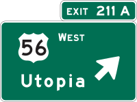
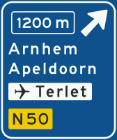
Destination signs (draft - in modification)
Destination signs specifically are one of the most complex and complete sets of information you can find in a road. It marks the destination, the direction, the way to, the distance...
You can use standard aproximation . You can find some ways to do it:
- Destination sign is tagged as a relation. This is to have unambigous guidance because you mark the roles node by node. But you have to do a relation-per-exit.The keys are destination, distance, time, colour:back, colour:text and colour:arrow.
- [Destination as a way] is used to mark the info by lanes or in ways where indicated destinations are identical from all directions.
Alternative aproximation
Tagged as a node. With the same scheme of the other traffic signs you have read above, including second or third panel (each mapped as individual sign). It includes all the elements you can see in the panel , and also all the destinations with the order and the position in the panels as a subtags. Then you can also write traffic sign as it is, with their lines and divisions, using letters and numbers.
Crossings and roundabouts
With this advanced scheme it is possible to map all kinds of crossings, normal roundabouts , tram roundabouts and turbo roundabouts. Also there is a set of tags for each available direction.
| Key | Derived keys | Direction | Example | Image |
|---|---|---|---|---|
| left=yes | destination:left
destination:left:2 destination:left:3 |

|
destination:left:3=Santa Isabel | 
|
| sharp_left=yes | destination:sharp_left
destination:sharp_left:2 destination:sharp_left:3 |

|
destination:sharp_left:2=Burgos | 
|
| u_turn=yes | destination:u_turn
destination:u_turn:2 destination:u_turn:3 |

|
destination:u_turn=L'Arboç | 
|
| sharp_right=yes | destination:sharp_right
destination:sharp_right:2 destination:sharp_right:3 |

|
destination:sharp_right=Allwood Rd EAST | 
|
| right=yes | destination:right
destination:right:2 destination:right:3 |

|
destination:right=Biel | 
|
| slight_right=yes | destination:slight_right
destination:slight_right:2 destination:slight_right:3 |

|
destination:slight_right=Atlantis | 
|
| through=yes | destination:through
destination:through:2 destination:through:3 |

|
destination:through=Indre - Basse Indre | 
|
| slight_left=yes | destination:slight_left
destination:slight_left:2 destination:slight_left:3 |

|
destination:slight_left=Ring road | 
|
| turbo_right=yes | destination:turbo_right
destination:turbo_right:2 destination:turbo_right:3 |

|
||
| tram_right=yes | destination:tram_right
destination:tram_right:2 destination:tram_right:3 |

|
destination:tram_right:symbol=motorway | 
|
| tram_through=yes | destination:tram_through
destination:tram_through:2 destination:tram_through:3 |

|
destination:tram_through=Gross-Köris | 
|
| tram_left=yes | destination:tram_left
destination:tram_left:2 destination:tram_left:3 |

|
destination:tram_left=Oude Maas | 
|
| tram_stop_left=yes | destination:tram_stop_left
destination:tram_stop_left:2 destination:tram_stop_left:3 |

|
destination:tram_stop_left:symbol=center | 
|
Place to attach it
...
Traffic signs don't fly, so you have to attach to somewhere. For example you can do that on a man_made=pole
Highway affectation of the traffic sign
...
Only you have to map it ON a highway point (node) with the only tag/value highway=traffic_sign .
Relation between traffic sign and highway
...............
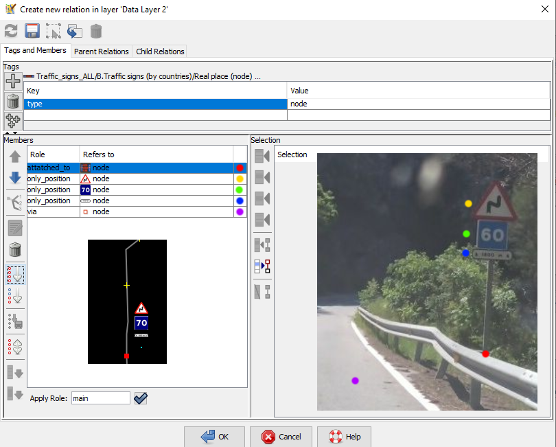
Use the relation type node with these roles:
-Every group of traffic signs make a relation with its pole and its "via" using a version of type=node (we will add the connection to the exact point -node- of road, like relation=enforcement.)
Example:
Why this if it more complicated than traffic_sign=* on a node in a highway?
- -It is on real place for the traffic sign(s), for the support and for the place it is affected by the traffic sign(s)
- -The use of freeform text for all is not understandable for some uses of OSM (statistics, inventories,etc.) and misses information for other items mapped on OSM.
- -Each item is mapped in its place (vertical and horizontal)
- -Each item is focused in a specific direction (so we can represent on 3D models)
- -Each traffic sign is registered at it is officially.
- -Each support is also mapped.
- -Developing tools would be easier with only nodes affected on the highways with the same tag and then would be easier for developers to make this available for the users.
See also
-Traffic_signs extended tagging 2024 proposal (rejected)
-Traffic sign Extended tagging 2017 proposal draft
Other people do
-traffic_sign=*
-Key:destination:symbol:forward
-Key:destination:symbol:backward
-Forward & backward, left & right
-Mapillary#Traffic sign recognition
-


