Wheelmap
| Wheelmap App | ||||||||||||||||||||||||||||||||||||||||||||||||||||||||||||||||||||||||||||||||||||||||||||||||||||||||||||||||||||||||||||||||||||||||||||||||
|---|---|---|---|---|---|---|---|---|---|---|---|---|---|---|---|---|---|---|---|---|---|---|---|---|---|---|---|---|---|---|---|---|---|---|---|---|---|---|---|---|---|---|---|---|---|---|---|---|---|---|---|---|---|---|---|---|---|---|---|---|---|---|---|---|---|---|---|---|---|---|---|---|---|---|---|---|---|---|---|---|---|---|---|---|---|---|---|---|---|---|---|---|---|---|---|---|---|---|---|---|---|---|---|---|---|---|---|---|---|---|---|---|---|---|---|---|---|---|---|---|---|---|---|---|---|---|---|---|---|---|---|---|---|---|---|---|---|---|---|---|---|---|---|---|
| Author: | Sozialhelden e.V. | |||||||||||||||||||||||||||||||||||||||||||||||||||||||||||||||||||||||||||||||||||||||||||||||||||||||||||||||||||||||||||||||||||||||||||||||
| License: | Apache License 2.0 (free of charge) | |||||||||||||||||||||||||||||||||||||||||||||||||||||||||||||||||||||||||||||||||||||||||||||||||||||||||||||||||||||||||||||||||||||||||||||||
| Platform: | Android | |||||||||||||||||||||||||||||||||||||||||||||||||||||||||||||||||||||||||||||||||||||||||||||||||||||||||||||||||||||||||||||||||||||||||||||||
| Version: | 5.4 (2024-12-16) | |||||||||||||||||||||||||||||||||||||||||||||||||||||||||||||||||||||||||||||||||||||||||||||||||||||||||||||||||||||||||||||||||||||||||||||||
| Languages: | English, French, German, Icelandic, Italian, Japanese, and Spanish
| |||||||||||||||||||||||||||||||||||||||||||||||||||||||||||||||||||||||||||||||||||||||||||||||||||||||||||||||||||||||||||||||||||||||||||||||
| Website: | https://www.wheelmap.org/ | |||||||||||||||||||||||||||||||||||||||||||||||||||||||||||||||||||||||||||||||||||||||||||||||||||||||||||||||||||||||||||||||||||||||||||||||
| Install: | ||||||||||||||||||||||||||||||||||||||||||||||||||||||||||||||||||||||||||||||||||||||||||||||||||||||||||||||||||||||||||||||||||||||||||||||||
| Source code: | https://github.com/sozialhelden/ | |||||||||||||||||||||||||||||||||||||||||||||||||||||||||||||||||||||||||||||||||||||||||||||||||||||||||||||||||||||||||||||||||||||||||||||||
|
Showing/setting which places are suitable for wheelchair users |
||||||||||||||||||||||||||||||||||||||||||||||||||||||||||||||||||||||||||||||||||||||||||||||||||||||||||||||||||||||||||||||||||||||||||||||||
| ||||||||||||||||||||||||||||||||||||||||||||||||||||||||||||||||||||||||||||||||||||||||||||||||||||||||||||||||||||||||||||||||||||||||||||||||
| Wheelmap Website | ||||||||||||||||||||||||||||||||||||||||||||||||||||||||||||||||||||||||||||||||||||||||||||||||||||||||||||||||||||||||||||||||||||||||||||||||
|---|---|---|---|---|---|---|---|---|---|---|---|---|---|---|---|---|---|---|---|---|---|---|---|---|---|---|---|---|---|---|---|---|---|---|---|---|---|---|---|---|---|---|---|---|---|---|---|---|---|---|---|---|---|---|---|---|---|---|---|---|---|---|---|---|---|---|---|---|---|---|---|---|---|---|---|---|---|---|---|---|---|---|---|---|---|---|---|---|---|---|---|---|---|---|---|---|---|---|---|---|---|---|---|---|---|---|---|---|---|---|---|---|---|---|---|---|---|---|---|---|---|---|---|---|---|---|---|---|---|---|---|---|---|---|---|---|---|---|---|---|---|---|---|---|
| Author: | Sozialhelden e.V. | |||||||||||||||||||||||||||||||||||||||||||||||||||||||||||||||||||||||||||||||||||||||||||||||||||||||||||||||||||||||||||||||||||||||||||||||
| License: | GNU GPL v3 (free of charge) | |||||||||||||||||||||||||||||||||||||||||||||||||||||||||||||||||||||||||||||||||||||||||||||||||||||||||||||||||||||||||||||||||||||||||||||||
| Platform: | Web | |||||||||||||||||||||||||||||||||||||||||||||||||||||||||||||||||||||||||||||||||||||||||||||||||||||||||||||||||||||||||||||||||||||||||||||||
| Version: | 1.0 (2011-03-28) | |||||||||||||||||||||||||||||||||||||||||||||||||||||||||||||||||||||||||||||||||||||||||||||||||||||||||||||||||||||||||||||||||||||||||||||||
| Languages: | English, French, German, Icelandic, Italian, Japanese, and Spanish
| |||||||||||||||||||||||||||||||||||||||||||||||||||||||||||||||||||||||||||||||||||||||||||||||||||||||||||||||||||||||||||||||||||||||||||||||
| Website: | https://wheelmap.org | |||||||||||||||||||||||||||||||||||||||||||||||||||||||||||||||||||||||||||||||||||||||||||||||||||||||||||||||||||||||||||||||||||||||||||||||
| Source code: | https://github.com/sozialhelden/wheelmap-frontend | |||||||||||||||||||||||||||||||||||||||||||||||||||||||||||||||||||||||||||||||||||||||||||||||||||||||||||||||||||||||||||||||||||||||||||||||
|
Browsing for wheelchair accessible places |
||||||||||||||||||||||||||||||||||||||||||||||||||||||||||||||||||||||||||||||||||||||||||||||||||||||||||||||||||||||||||||||||||||||||||||||||
| ||||||||||||||||||||||||||||||||||||||||||||||||||||||||||||||||||||||||||||||||||||||||||||||||||||||||||||||||||||||||||||||||||||||||||||||||
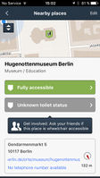
Wheelmap (wheelmap.org) is a map for wheelchair accessible locations. There is a website, an iPhone app and an Android app available for this use case at the moment. The site and app let you find out if a location is accessible or not. You can search for and tag locations yourself.
I have a similar project, can we cooperate?
For sure! If you also use OpenStreetMap we’re already sharing all location data with you. If you want to help us develop wheelmap.org, talk to us. Anything else? Just contact us via Direct Message of this Wiki or via our Contact form on out website
Who is behind wheelmap?
Wheelmap is an initiative of “Sozialhelden e.V.”(de), a German non-profit association located in Berlin.
Are you planning for your site to be global?
Yes, since OpenStreetMap is a global project, the data of the entire world is on the map already.
The wheelmap website and iPhone App are already available in the following languages:
- English
- German
- Spanish
- French
- Islandic
- Italian
- Japanese
- Greek
- Klingon
We are looking for more regional ambassadors who also want to promote wheelchair accessibility through transparency. Contact us if you want to help!
Do you plan on letting people post specific information about accessibility?
Yes, we use a wheelchair description tag that has been approved by OpenStreetMap.
Is Wheelmap intended to address just wheelchair accessibility, or might you also cover access for people with vision or hearing impairments etc?
We want to concentrate on wheelchair accessibility because we believe that blind and deaf people need different solutions, and we should not put them in the same box. Nevertheless, we believe that the source code of wheelmap could be developed further to meet those needs.
Do you have an iPhone app?
Yes. You can find it on the App Store but there are several other apps too. You can use iLOE or Mapzen POI collector to tag the accessibility of places and use iLOS or Leisure to find out about the wheelchair accessible status of places around you. And since the OpenStreetMap community is growing, expect more to come.
What conventions do you use to tag places?
We use those which are approved by the OpenStreetMap community. See wheelchair=*. Simply put, it’s “yes” (fully accessible), “limited” (partly accessible, e.g., no access to toilet) and “no” (not accessible). In the wheelchair:description=* tag we plan to store additional information about the accessibility. Wheelmap user can also mark wheelchair accessible toilets using the toilets:wheelchair tag.
How can I contribute?
- You can add locations to openstreetmap.
- You can add wheelchair accessibility to openstreetmap by using https://wheelmap.org
- You can help to translate the wheelchair relates openstreetmap pages to your language, see Category:Walking Disability
- You can help to translate the web portal and iPhone App https://wheelmap.org to your language. Contact us if you want to help!
Statistics & Mission
The current number of tagged places grows steadily (around 200 per day). Find the number in the lower left corner of https://wheelmap.org
Our mission is to collect a lot of data from all kind of organizations. We are currently talking to a lot of people in the government / administration area but also with some representatives of larger corporations too. Stay tuned!
Is wheelmap fully open sourced?
Yes, we have open sourced the Android and iOS apps and some other tools we have made under the Apache 2.0 license. The website and backend (including the API) is available under the GPLv3 license. The Windows Phone app is available on GitHub as well.
How can we identify Wheelmap as a data source in OpenStreetMap
The OpenStreetMap user wheelmap_visitor (on osm, edits, contrib, heatmap, chngset com.) is used to enter tags which have been added by anonymous visitors of wheelmap.org or the mobile apps. Wheelmap users who edit more than just the wheelchair-tag have to connect Wheelmap with their own openstreetmap-account.
Previously also wheelmap_android (on osm, edits, contrib, heatmap, chngset com.).
See also
- Wheelchair map - A similar project
- wheelchair=* - Access tag for wheelchairs
- Wheelchair routing - Informations about routing for wheelchair users
- Rollstuhlkarte.ch(de) - Another wheelchair map
- Key:dehoga - German standard for hotels and restaurants
- Disabilities - Tags and features that will be relevant for users with disabilities.
- List of OSM-based services


