Zh-hant:Editing Standards and Conventions
以下是編輯OSM地圖的一些"標準和傳統",對於基本的編輯請看Editing。
貼上標籤(Tagging)
你可以給予標籤於任何點(node)、街道(way)、區域(closed way)或 關係(relation)。 你可以在地圖圖徵頁面中找到一系列建議的標籤,建議你看一看此頁面的資訊且熟悉被大多數接受的且可使用在多數秀圖軟體和工具的標籤。請注意,雖然任何關鍵(keys)和值(values)是有效(valid)且或許可以用在OSM上,Zh-hant:Map Features 的標籤的任何改變或更新都是經過投票所決定的。
Good practice 頁面中有一些貼上標籤的要點。
在FAQ中可以找到更多有用的提示,如一個標籤如何使用多個值multiple values 。
Roads
一個物理性的道路、街道、和步道等都是由一系列的點(nodes)以構成線(ways)。這樣的線被貼上道路[([highway]])的標籤和名字。
許多線在多數的OSM編輯器中的出現是相同的,是以根據所鍵入的標籤值,用不同的顏色和寬度來顯示。
街道名(Street Names)
在name 標籤中,輸入在出現在路牌上的街道名。使用混合大小寫,字首英文字母應大寫,如Church Street, 不是 Church street,不要用名字的縮寫,在OSM中現在沒有縮寫標準表,如St.可以是Street也可以是Saint。
小心撇號(’)的使用,應用同一個規則,如果路牌上撇號,OSM的資料就應該有。但這時常有明顯的不一致,因為同一名字有的路牌有,但有的路牌沒有,如倫敦地鐵站Earl's Court。
請同時參照 雙語街道名
沒有名稱的道路(Roads without names)
Sometimes a road does not have a name (in the real world). That's fairly rare, but it sometimes happens. In this case, enter the highway tag, but not the name tag.
Often a road has a name, but you don't know what it is. This might be because you didn't write it down while you were out surveying. Maybe you used a camera but the picture came out blurry. Or maybe you are sketching over Yahoo! Imagery. These kinds of roads should be drawn in as ways tagged with highway=road as per the guidelines on Yahoo! Aerial Imagery#How to sketch? ... however not everyone follows this, and "sketched" roads are often left untagged or given some other highway tag by a reasonable guess.
One way streets
If traffic can only travel down a road oneway then it is important to draw the way in the direction of travel and then add a oneway=yes.
Divided highways
A divided highway (also separated highway) is any highway where traffic flows are physically separated by a barrier (e.g., grass, concrete, steel), which prevents movements between said flows. While divided highways typically consist of two opposing traffic flows, such as with dual carriageways, they can also consist of three or more divided sections having a combination of same-direction and opposing flows, such as highways with "local" and "express" lanes (whereby entries to and exits from the highway are possible only from the former).
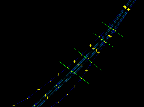
Divided highways should be drawn as separate ways. The ways will typically be oneway, and should be tagged as such where appropriate. Ways connecting the divided ways should be drawn at locations where movements between the divided ways are possible, that is, where the physical separation is interrupted. Where the divided ways are parallel (often, but not always) their nodes should be positioned so that they are adjacent to each other. This creates a more pleasing aesthetic effect in renderers, especially on curves. It also preserves the information on their mutual separation distance along their whole length. As with any ways, the spacing between is governed by the need to accurately represent curves (see below)
Roundabouts
Roundabouts are discussed in detail on Roundabouts.
Junctions
|
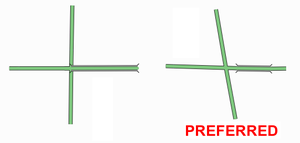
All road junctions should be drawn as a node with connecting paths. It is incorrect to add a node that appears to be on a path but is actually not connected. While this might look right, it will not define a valid path from one road to the other. |
Bridges
A bridge is drawn as a separate way. This is one of many situations where a road is no longer represented as a single way, but as several ways arranged end-to-end, each with different tagging. The editors provide an easy way to split a way at a given node, for this purpose.
The highway and name tag should be applied throughout. The short way representing the bridge should additionally be tagged with bridge=yes and layer=x, where x is one more than the layer tag of the road underneath (or 1 if there is no layer tag on the road underneath).
Often the bridge will not connect directly to a junction, in which case you should add a piece of road connecting the two (see image).
See Key:bridge for details.
Tagging Areas
On some occasions the feature you wish to tag is not represented by a line (as is the case of a road, river, rail line etc), but by an area. For instance a wooded area, a park, or a lake are all map features which are areas. Create a new closed way which represents the outline of the required area. Annotate this way with the required tagging from the map features page, such as natural=water (for a lake), landuse=forest (for a forest), or leisure=park (for a park), etc. There is no consensus yet on how to draw areas adjacent to ways. They may be drawn either by leaving a small gap between the area and the way or by sharing the boundary.
Accuracy
TODO: Merge text this onto the Accuracy page
Accuracy is important. The GPS system provides fixes that can be accurate to 1-10 m which is more than good enough for this project. Do bear in mind, however, that a road can be several metres wide and a GPS fix could have been made anywhere in the road or even on the pavement. For many purposes accuracy to a few metres is plenty good enough. What is equally important however is topological accuracy. Do two roads intersect at the same point (a crossroads) or is the intersection offset? This detail may only be a matter of a few metres, but can be the difference between driving instructions that might say at the crossroads go straight ahead or at the junction turn left and then after 10 metres, turn right.
When tracing roads — particularly winding, rural ones — you should add enough points to make each curve look like a curve. Of course, this is entirely subjective, as curves made entirely of lines will only ever approximate a "true" curve (which has an infinite number of nodes), and will always look like a series of lines when zoomed in past a certain point no matter how many nodes there are. Any "rule of thumb" as to node spacing and quantity would be arbitrary and capricious. To generalize, though, sharp curves (those having a small radius) require many, closely-spaced nodes, while broad, long-radius curves can consist of fewer nodes having more distance between them. Without a hard-and-fast rule, it is best said to simply use good judgement and strive to seek a balance: on one hand, remember that you are drawing a map, not just a routing diagram; on the other hand, don't try to seek perfection by adding more and more nodes past the point of diminishing returns, keeping in mind that each additional node requires that more data be stored and transferred.
Note: Keep in mind that the road in the diagram below is about 2 km long. For very short roads you do not need to add that many nodes.
How not to do it
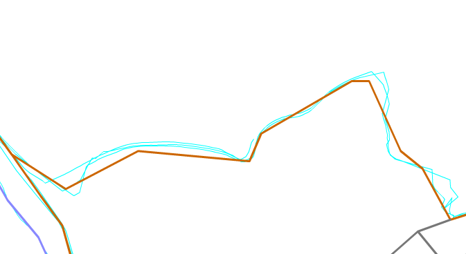
The above is an example of a very roughly-traced rural 2-kilometer road. Drawing roads like this isn't helpful. When someone comes along to do it properly, he will have to work hard to refine this way by adding lots of points into it and adjust them.
How to do it
This is the same 2-kilometer road - but this will look much better on the map, and gives the map user a better sense of the curves of the road.
Before deleting a whole road, check that the nodes don't themselves have tags. Potlatch will alert you if they do (it also highlights tagged nodes in black).
You can see the road here. Other mapping services have a similar degree of accuracy.
Dates
Dates should be in ISO 8601 format, i.e. YYYY-MM-DD. Where a numeric day of week is necessary, Monday=1, Sunday=0 or 7.
Miscellaneous
- Intersections and interchanges - These are most likely to be always improved by someone else, no matter how much detail you put in
- The initial level of detail should include correct connections from/to each road and link road and the existence of any bridges and underpasses; remember to set oneway tags where applicable.
- For intersections any pedestrian crossings are valuable information; add a node in the way they cross at their location
- After that there's still lots of detail that can be added (as with all roads: number of lanes, speed limits, lit=yes/no
- Accuracy. How do you judge and or indicate the accuracy? How accurate is good enough? Is a rough approximation better than nothing (i.e. inaccurate roads get refined the way wikipedia articles do).
- A GPS trace is almost always more accurate than other sources available to us. Still several, even tens of traces can be used to improve the accuracy. Do note though:
- Sometimes and in some environments the GPS trace can wander off to some direction (often 15-30 meters but even 90 meters); compare the trace with your memory, photos and notes to see if straight roads appear as a reasonably straight set of trace points.
- If it's a new road (nothing previously entered in the area) and there aren't any aerial images available, draw it in anyway
- If there are already other roads around and your trace seems bad, try to deduce the "real" form from the trace by not crossing roads that don't intersect with the road you traced.
- How accurate is good enough varies with each user:
- For most uses it's accurate enough when it's not misleading: say when a cycleway drawn on the map
- shows all correct bends and intersections
- and no nonexistent ones
- and is on the right side of the nearby road / stream / railway
- and is roughly the correct distance away from those features (some editors have support for measuring distances)
- Some may later want to draw fences, hedges and walls around the houses (where they exist); they will have mapped their locations to within a few meters by repeated traces and considerable amount of deducing and aligning things in lines
- For most uses it's accurate enough when it's not misleading: say when a cycleway drawn on the map
- Not only inaccurate roads, but those lacking secondary information, are refined later anyway. When contemplating on whether to approximate some road, try to consider if a user would find any value in the approximated form - is it likely to be within, say, 50 meters from the real location at all times (in otherwise unmapped territory)? If you approximate, do add a source=approximation or similar tag to the way.
- A GPS trace is almost always more accurate than other sources available to us. Still several, even tens of traces can be used to improve the accuracy. Do note though:
- Is it constructive/helpful to mark a road that you know is roughly in the right place but don't have any supporting GPS data?
- This depends again on what else is there:
- If an urban road is missing in a rectangular grid and you confirmed its existence and it was, say, roughly halfway between the parallel roads: the position is likely to be almost as good as the position of those parallel streets when you draw it in.
- If the missing road ventures into the unmapped territory winding along the way, it's likely better to draw just a stub for the starting point and add a FIXME=continue on the last node. If one were to draw the full way freehand, it would very likely be too short/stretched/skewed - unless there are good aerial images available.
- This depends again on what else is there:
- Landmarks, footpaths, etc.?
- How do you indicate that one road passes over or under another? - See the description for bridges above, and Key:bridge.
- If a road is made up of several/many ways, all ways should carry the name and/or ref tags.
Topology
- Is correct topology more or less important than accurate location?
- In the end both are equally important and not even mutually exclusive, but since with our tools the topology can be surveyed more accurately than the location, it should be always kept correct, even if that leads to some nodes being some meters more off than otherwise.
- If a road is a dual carriageway it should be shown as two lines
- If a road has a small traffic island (eg at the approach to a large roundabout) should this be represented as a triangle or not? How big should it be before it should be drawn?
WARNING: OpenStreetMap is highly addictive For some people the process of mapping on OpenStreetMap is highly addictive. Take frequent breaks, there is a lot to be done.


