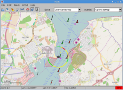
| florb
|
|
|
| Author:
|
Björn Rehm
|
| License:
|
MIT License (free of charge)
|
| Platform:
|
Linux
|
| Version:
|
1.1 (2016-02-28)
|
| Languages:
|
German and English
|
| Website:
|
http://florb.shugaa.de
|
| Source code:
|
https://www.github.com/shugaa/florb
|
| Programming language:
|
C++
|
|
A simple map viewer and GPX editor
|
|
Features
| Feature
|
Value
|
| Map Display
|
| Display map
|
yes
|
| Map data
|
raster
|
| Source
|
online;cache;offline
|
| Rotate map
|
no
|
| 3D view
|
no
|
| Shows website
|
?
|
| Shows phone number
|
?
|
| Shows operation hours
|
?
|
| Routing
|
| Routing
|
no
|
| Create route manually
|
?
|
| Calculate route
|
no
|
| Create route via Waypoints
|
?
|
| Routing profiles
|
?
|
| Turn restrictions
|
no
|
| Calculate route without Internet (Offline routing)
|
no
|
| Routing providers
|
?
|
| Avoid traffic
|
?
|
| Traffic Provider
|
?
|
| Navigating
|
| Navigate
|
no
|
| Find location
|
yes
|
| Find nearby POIs
|
no
|
| Navigate to point
|
no
|
| Navigation with voice / Voice guidance
|
no
|
| Keep on road
|
no
|
| Lane guidance
|
?
|
| Works without GPS
|
yes
|
| Navigate along predefined route
|
no
|
| Tracking
|
| Make track
|
yes
|
| Customizable log interval
|
no
|
| Track formats
|
gpx
|
| Geotagging
|
no
|
| Fast POI buttons
|
yes
|
| Upload GPX to OSM
|
no
|
| Monitoring
|
| Monitoring
|
yes
|
| Show current track
|
yes
|
| Open existing track
|
yes
|
| Altitude diagram
|
no
|
| Show POD value
|
yes
|
| Satellite view
|
no
|
| Show live NMEA data
|
no
|
| Show speed
|
no
|
| Send current position
|
no
|
| Editing
|
| Add POIs
|
no
|
| Edit / Delete POIs
|
no
|
| Add way
|
no;
|
| Edit geometries
|
no
|
| Edit arbitrary tags of existing OSM objects
|
no
|
| Edit relations
|
no
|
| View notes
|
?
|
| Create notes
|
?
|
| Edit notes
|
?
|
| Work offline
|
?
|
| Support imagery offset DB
|
no
|
| Upload to OSM
|
no
|
| Rendering
|
| Renderer output formats
|
gpx
|
| Accessibility
|
| Accessibility support
|
?
|
| Complete non graphics text output
|
no
|
| Braille interface
|
no
|
| Exploration modus
|
no
|
| Public Transport mode
|
no
|
| Danger Warnings
|
no
|
| Screenreader
|
?
|
| Screenreader languages
|
?
|
|
|
About
florb is a really simple map viewer and GPX editor written in C++ using the FLTK UI toolkit. florb makes it easy to create and edit tracks for planning short and extended trips into the wild green. Or anywhere else for that matter.
Features
- User configurable tile servers (e.g. OpenStreetMap, Google Maps and many others)
- Automatic map dowloading
- Tile cache with metadata storage (expiration date)
- Map overlay support
- GPSd support incl. track recording
- GPX import and export
- Editing of existing GPX tracks
- Creating new GPX tracks through simple point and click
- Up- and download tracks to and from Garmin devices
- Places search (OSM Nominatim)
- Bulk tile download
- View elevation profile for complete track or selected waypoints
- Localization support (German translation)
| GPS related articles |
|---|
| | Main | GPS with good internal links, GNSS. Another formats: NMEA, FIT (Garmin), | | | GPX tracks: create | List of GPS trace file formats, GPX, Why not GPX?, GPX viewer and recorder (Windows™ only), OpenGpxTracker (iOS™ only), Gps Event Sync, GPX extractor, OsmAnd, MAPS.ME, GpsMid (J2ME), Gpsd | | | GPX tracks: convert | | | | GPX tracks: upload | | | | Visualise | | | | Hardware (receivers) | | | | Accuracy | | | | Other | |
|
