Key:width:effective
Jump to navigation
Jump to search
| Description |
|---|
| Effective usable width of a feature, especially the usable width of carriageway, i.e. the width of the area on which vehicles move in flowing traffic. |
| Used on these elements |
| Useful combination |
|
| See also |
|
| Status: in use |
| Tools for this tag |
|
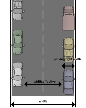
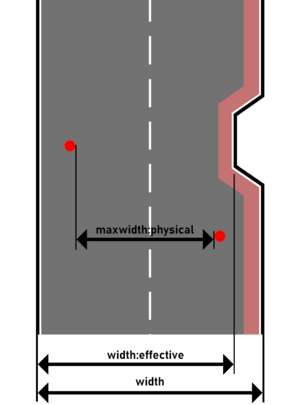
The key width:effective describes the effective usable width of a way or other feature. For a road or street, this means the width of the area on which vehicles move in flowing traffic. By default, values will be interpreted as metres.
The effective usable width of a road can also be derived from other tags, in particular the total width of the carriageway minus the width of parking lanes, cycle lanes and shoulders (see also: Key:width#Width_of_streets).
As of early 2025, width:effective=* is rarely used and only by a few mappers.
Examples
 width:effective=* on a street with parking lanes/parked cars. |
 width:effective=* on a road where it's width=* isn't a static constant for the whole length of a road. |
See also
- width=* describes the actual width of a way or other feature.
- maxwidth=* specifies a legal restriction of the maximum permissible width of a vehicle in order to use a way or other feature. Thus this key doesn't refer to the actual feature on OSM but to the vehicles.
- maxwidth:physical=* expresses a physical width limit for using the way or passing a barrier to which the tag is added. This key also refers to the vehicles and not the actual feature on OSM, it's just this is a physical limitation not a legal limitation as set by the maxwidth=* key.
