Ko:OruxMaps
| OruxMaps | ||||||||||||||||||||||||||||||||||||||||||||||||||||||||||||||||||||||||||||||||||||||||||||||||||||||||
|---|---|---|---|---|---|---|---|---|---|---|---|---|---|---|---|---|---|---|---|---|---|---|---|---|---|---|---|---|---|---|---|---|---|---|---|---|---|---|---|---|---|---|---|---|---|---|---|---|---|---|---|---|---|---|---|---|---|---|---|---|---|---|---|---|---|---|---|---|---|---|---|---|---|---|---|---|---|---|---|---|---|---|---|---|---|---|---|---|---|---|---|---|---|---|---|---|---|---|---|---|---|---|---|---|
| 제작: | Jose | |||||||||||||||||||||||||||||||||||||||||||||||||||||||||||||||||||||||||||||||||||||||||||||||||||||||
| 라이선스: | freeware (무료) | |||||||||||||||||||||||||||||||||||||||||||||||||||||||||||||||||||||||||||||||||||||||||||||||||||||||
| 플랫폼: | Android | |||||||||||||||||||||||||||||||||||||||||||||||||||||||||||||||||||||||||||||||||||||||||||||||||||||||
| 버전: | v6.0.4 (2014-12-21) | |||||||||||||||||||||||||||||||||||||||||||||||||||||||||||||||||||||||||||||||||||||||||||||||||||||||
| 언어: | 영어, 한국어
| |||||||||||||||||||||||||||||||||||||||||||||||||||||||||||||||||||||||||||||||||||||||||||||||||||||||
| 웹 사이트: | http://www.oruxmaps.com/index_en.html | |||||||||||||||||||||||||||||||||||||||||||||||||||||||||||||||||||||||||||||||||||||||||||||||||||||||
|
OruxMaps 는 맵 뷰어입니다. 두가지 모드로 작동합니다: 온라인 모드와 오프라인 모드: online with google, microsoft, yandex,... maps, and offline with calibrated maps for OruxMaps, or online maps which have been saved |
||||||||||||||||||||||||||||||||||||||||||||||||||||||||||||||||||||||||||||||||||||||||||||||||||||||||
| ||||||||||||||||||||||||||||||||||||||||||||||||||||||||||||||||||||||||||||||||||||||||||||||||||||||||
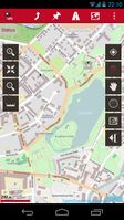
OruxMaps (oruxmaps.com) 는 Android 앱이다.
It can display OpenStreetMap maps (raster tiles and vector maps from Mapsforge) and has tracking and waypoint recording features making it suitable for gathering data. It can use offline vector maps or display map tiles online or pre-downloaded from a variety of sources. OruxMaps can also use SRTM elevation data to display 3D views of maps.
오럭스는 OSM 지도를 보여주고, 데이터를 수집하는 적합한 기능으로 트랙과 포인트를 기록한다. 오프라인 지도로 Mapsforge 벡터지도를 사용하거나 온라인 지도로 래스터 지도를 사용한다. 또는 다양한 지도를 다운로드하여 사용한다. 오럭스는 3차원 지도를 보여주기 위해 STRM 고도데이터를 사용한다.
On the Mapsforge project page there is plug-in for Osmosis that allows to compile vector maps from OSM data for offline usage. Meanwhile many vector maps are readily available for download and the use of online sources is discouraged.
Mapsforge 프로젝트 페이지에 Osmosis에 대한 플러그인이 있다, 이는 OSM 데이터를 오프라인으로 사용하기 위한 벡터 맵을 컴파일 할 수 있습니다. 한편 많은 벡터지도를 다운로드 하여 쉽게 사용할 수 있으며, 온라인 소스의 사용은 권장하지 않습니다.
Recommended as an OpenStreetMap "power-user" Android app
지도 보기 ; Displaying maps
Online
To display our maps go to [menu -> Maps -> 'To online maps'] and select from the available maps e.g. :
- 'OpenStreetMap Mapnik' for the default maps seen on http://openstreetmap.org (the default osm Mapnik style)
- '4UMaps' Outdoor map for hiking, cycling and mountain biking 4UMaps
- 'OpenStreetMap Cyclemap' for cycle routes and terrain rendering as seem on OpenCycleMap.org
- 'OpenSeaMap' for a marine/sailing themed rendering (OpenSeaMap)
- 'CloudMade' for CloudMade's default OpenStreetMap rendering
Additionally you can also select 'Microsoft earth' which is the bing imagery which we can use to make maps from.
오프라인 지도 ; Offline
There are raster- and vector maps available, many of them free of charge.
벡터지도 ; Vector Maps
Vector maps (.map) should be installed on the sd card in the folder /sdcard/oruxmaps/mapfiles. The vector maps now come with additional style files that should be also installed. You can also create sub-folders to organize the maps. In the map dialog you can then go to offline maps and chose you map.
Vector maps desainded for hiking and outdoor purposes are available at openandromaps.org.
벡터 맵 (.map)은 /sdcard/oruxmaps/mapfiles 폴더의 SD 카드에 설치해야 합니다. 벡터 지도는 추가 스타일 파일을 제공하며 설치되어야 합니다. 또한 지도 스타일을 구성하기 위해 하위 폴더를 만들 수 있습니다. 지도 대화 상자에서, 오프라인 지도 전환으로 가서 지도를 선택할 수 있습니다.
하이킹과 야외 목적을 위해 디자인된 벡터지도는 openandromaps.org에서 구할 수 있습니다.
The maps available from the project site mapsforge.org are currently not updated.
If you want to create a custom offline map from OSM Data you can use the Osmosis MapWriter Plugin to create a offline vector map.
프로젝트 사이트에서 사용할 수 있는 지도[1]는 현재 업데이트되지 않습니다.
OSM 데이터에서 사용자 정의 오프라인 맵을 만들려면, Osmosis MapWriter 오프라인 벡터지도를 만드는 플러그인를 사용할 수 있습니다.
Here a description how to add contourlines to the maps from OSM from the Oruxmap Forum
Alternatively you can use Mopac to convert the OSM Tiles to use them offline in OruxMaps. This is only useful for small maps.
여기에서 설명하는 방법는 Oruxmap 포럼에서 OSM의 지도에 등고선을 추가할 수 있다
또는 OruxMaps에서 오프라인으로 사용하기 위해 OSM 타일을 변환하여 MOPAC를 사용할 수 있습니다. 이것은 작은 지도에만 유용합니다.
래스터 지도; Raster Maps
Ready to go topographic maps for outdoor activities are available here 4UMaps Download Simply copy the files into the /oruxmaps/mapfiles folder on the sd card, and select offline map from the main menu.
야외 활동을 위한 지형도를 준비하려면 여기에서 이용할 수 있다 4UMaps 다운로드 간단하게 SD 카드에 /oruxmaps/mapfiles 폴더에 파일을 복사하고, 주 메뉴에서 오프라인 맵을 선택합니다.
트랙 레코딩; Recording tracks
- Tracks(경로) are stored in the internal database and can be exported to a .gpx file which can be uploaded to OSM.
- 경로는 내부 데이터베이스에 저장된다. 그리고 OSM에 업로드할 수 있는 .gpx 파일로 내보기기 된다.
- 트랙 레코딩 민감도는 3가지 요소로 GPS 설정에서 세팅한다.
- Track Recording sensibility can be set in the menu settings GPS with tree parameters:
- GPS 측정사이의 최소 시간. The higher, lower battery consumption.
- GPS 측정사이의 최소 거리.
- 수신된 위치를 기록하기 위한 최소 정확도.
[TODO document]
See also:
There are vector based CycleMaps avaiable at http://www.openandromaps.org
