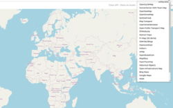
OSM Smart Menu
| OSM Smart Menu | ||||||||||||||||||||
|---|---|---|---|---|---|---|---|---|---|---|---|---|---|---|---|---|---|---|---|---|
| Author: | jgpacker | |||||||||||||||||||
| License: | GNU GPL v3 (free of charge) | |||||||||||||||||||
| Platforms: | Windows, Windows XP, Linux, macOS, and Android | |||||||||||||||||||
| Status: | Unmaintained | |||||||||||||||||||
| Languages: | English, Brazilian Portuguese, and Chinese (Taiwan)
| |||||||||||||||||||
| Source code: | jgpacker/osm-smart-menu GitHub | |||||||||||||||||||
| Programming languages: | HTML, CSS, and TypeScript | |||||||||||||||||||
|
Helps OpenStreetMap contributors to easily switch between different maps and analysis tools from the community. |
||||||||||||||||||||
| ||||||||||||||||||||
| OSM Smart Menu seems unmaintained. Last announcement was in year 2020. |
This browser extension[1] is officially available for Google Chrome[2] and Mozilla Firefox (for Desktop[3] and Android[4]).
It helps users to open links related to OpenStreetMap, based on parameters from the current page. Supported parameters include map parameters (zoom, latitude and longitude) and OpenStreetMap attributes (user name, node ID, changeset ID, etc). In a nutshell, this extension is a superior alternative to Bookmarklets.
New features are announced at the author's user diary.
Report bugs or request features
You can send a message to the author's OpenStreetMap account or open a new issue at Github.
Configuration
Besides the default list of links, users can add their own links!
Easy method to add new links
The easy way is to simply go to the desired website (example), and click on the OSM extension button. If the website's URL pattern is recognized, an option will appear to add the current page's link to the list.
However,
- It only works for maps (i.e. with latitude, longitude and zoom parameters);
- It only works for a few known URL patterns.
Advanced method to add new links
In the configuration page, new links can be added with an URL Template. See some examples below:
- Edit with JOSM or Merkaartor(should be configured in Openstreetmap.org My preferences and should be running. (see issue :
https://www.openstreetmap.org/edit?editor=remote#map={zoom}/{latitude}/{longitude} - Compilation of several map links:
https://geohack.toolforge.org/geohack.php?params={latitude}_N_{longitude}_E - Query OSM Elements:
http://www.overpass-turbo.eu/?C={latitude};{longitude};{zoom}
At least one bracket parameter must be inside the URL Template. The URL Template supports the following parameters:
- {zoom}
- {latitude}
- {longitude}
- {osm_changeset_id}
- {osm_user_name}
- {osm_node_id}
- {osm_way_id}
- {osm_relation_id}
- {osm_tag_key} and {osm_tag_value}
This is still an experimental feature.
More examples for advanced method using custom code
| Name | Template | Usage |
|---|---|---|
| Apple Maps | https://beta.maps.apple.com/?ll={latitude}%2C{longitude}&spn=0.02724242880691463%2C0.07252723824063878 | Map, Street View ⚠© Not suitable as source |
| iD released | https://ideditor-release.netlify.app/#background=Bing&disable_features=boundaries&map={zoom}/{latitude}/{longitude} | Editor |
| iD development | https://ideditor.netlify.app/#background=Bing&disable_features=boundaries&map={zoom}/{latitude}/{longitude} | Editor |
| Rapid | https://rapideditor.org/rapid#map={zoom}/{latitude}/{longitude} | Editor |
| WaymarkedTrails | https://hiking.waymarkedtrails.org/#?map={zoom}!{latitude}!{longitude} | Niche |
| Bikerouter | https://bikerouter.de/#map={zoom}/{latitude}/{longitude} | Router (biking and hiking) |
| Brouter Navigation | http://brouter.de/brouter-web/#map={zoom}/{latitude}/{longitude}/standard | Router (biking and hiking) |
| Flopp's Map | https://flopp.net/?c={latitude}:{longitude}&z={zoom} | Map (OSM, Topo, Google Maps), waypoint tools |
| OpenRouteService | https://maps.openrouteservice.org/directions?n1={latitude}&n2={longitude}&n3={zoom}&b=0&k1=en-US&k2=km | Router |
| Geohack | https://geohack.toolforge.org/geohack.php?params={latitude}_N_{longitude}_E | List of lists |
| Commons: Nearby images | https://wikimap.toolforge.org/?wp=false&basemap=2&cluster=false&zoom={zoom}&lat={latitude}&lon={longitude} | Pictures |
| Panoramax | https://api.panoramax.xyz/#focus=map&map={zoom}/{latitude}/{longitude} | Federated field photos database |
| Google Street View | https://www.google.com.tw/maps/?layer=c&cbll={latitude},{longitude} | Street View ⚠© Not suitable as source |
| Opening hours | https://openingh.ypid.de/?zoom={zoom}&lat={latitude}&lon={longitude}&layers=B0T&filter=none&tags=opening_hours | |
| OSM Blitzermap | http://frink.bplaced.de/blitzer/#map={zoom}/{latitude}/{longitude} | QA |
| Map of turn restrictions | https://ahorn.lima-city.de/tr/?zoom={zoom}&lat={latitude}&lon={longitude}&layer=Grayscale&overlays=TTT | QA |
| OpenSkiMap | https://openskimap.org/#{zoom}/{latitude}/{longitude} | QA |
| OpenSnowMap | https://www.opensnowmap.org/#map={zoom}/{longitude}/{latitude}&b=snowmap&m=false&h=false | QA |
| Maxspeed (OpenStreetBrowser) | https://www.openstreetbrowser.org/#map={zoom}/{latitude}/{longitude}&categories=car_maxspeed | QA |
| OSM Relation Analyzer (overview) | http://ra.osmsurround.org/analyzeRelation?relationId={osm_relation_id} | QA |
| OSM Relation Analyzer (map) | http://ra.osmsurround.org/analyzeMap?relationId={osm_relation_id} | QA |
| Destination Signs | http://osm.mueschelsoft.de/destinationsign/example/#way={osm_way_id}&namedroutes=0&fromarrow=0&include_sgn=0&include_way=1&country=DE | QA |
| Destination Signs | http://osm.mueschelsoft.de/destinations/example/#wayid={osm_way_id}&direction=0&country=DE | QA |
| Destination Signs Sandbox | http://osm.mueschelsoft.de/destinations/example/sandbox.htm#country={osm_way_id} | QA |
| OSM Lane Visualizer | https://osm.mueschelsoft.de/lanes/render.pl?wayid={osm_way_id}&start=1&country=de | QA |
| Maptiler VectorMap | https://www.maptiler.com/maps/#streets//vector/{zoom}/{longitude}/{latitude} | Map |
| Osmlab changeset map | http://osmlab.github.io/changeset-map/#{osm_changeset_id} | Changeset-viewer |
| Achavi | https://overpass-api.de/achavi/?changeset={osm_changeset_id} | Changeset-viewer |
| OSMCha | https://osmcha.org/changesets/{osm_changeset_id} | Changeset-viewer |
| CbCV (Neis) | https://resultmaps.neis-one.org/osm-change-viz?c={osm_changeset_id} | Changeset-viewer |
| Level0 | http://level0.osmz.ru/?url=changeset/{osm_changeset_id} | Editor |
| OSM Wiki Key | https://wiki.openstreetmap.org/wiki/Key:{osm_tag_key} | Environment |
| OSM Wiki Value | https://wiki.openstreetmap.org/wiki/Tag:{osm_tag_key}%3D{osm_tag_value} | Environment |
| TagInfo Key | https://taginfo.openstreetmap.org/keys/{osm_tag_key} | Environment |
| TagInfo Value | https://taginfo.openstreetmap.org/tags/{osm_tag_key}={osm_tag_value} | Environment |
| Osmose (fix) | https://osmose.openstreetmap.fr/fr/map/#loc={zoom}/{latitude}/{longitude} | QA |
| Lanes Map | https://osm-tiles.james-ross.co.uk/?map={zoom}/{latitude}/{longitude}&layer=standard&layer=overlay&layer=roads | QA |
| OSM Latest Changes rene78 | https://rene78.github.io/latest-changes/#{zoom}/{latitude}/{longitude} | QA |
| Parking lanes Map | https://zlant.github.io/parking-lanes/#{zoom}/{latitude}/{longitude} | QA |
| Bus lanes Map | https://zlant.github.io/bus-lanes/#{zoom}/{latitude}/{longitude} | QA |
| OSM-Streetlight | http://osmstreetlight.bplaced.net/#{zoom}/{latitude}/{longitude} | QA |
| OSM 411 | https://osm411.org/#map={zoom}/{latitude}/{longitude} |
See also
- OpenSwitchMaps - browser extension
- Better-osm-org - User script to enhance openstreetmap.org
- M-Reimer/osm-everywhere GitHub - browser extension OSM Everywhere
- OSM 411 - Customizable link directory for OpenStreetMap projects - quincylvania/osm-411 GitHub
Outdated due to browser technology advancement
- Bookmarklet - Bookmarklet are small pieces of JavaScript code which you store and run on-demand in your browser to conveniently access tools for your OSM work
- Bookmarklets - List of OSM related bookmarklets
