OSMfocus
| OSMfocus | ||||||||||||||||||||||||||||||||||||||||||||||||||||||||||||||||||||||||||||||||||||||||||||||||||||||||
|---|---|---|---|---|---|---|---|---|---|---|---|---|---|---|---|---|---|---|---|---|---|---|---|---|---|---|---|---|---|---|---|---|---|---|---|---|---|---|---|---|---|---|---|---|---|---|---|---|---|---|---|---|---|---|---|---|---|---|---|---|---|---|---|---|---|---|---|---|---|---|---|---|---|---|---|---|---|---|---|---|---|---|---|---|---|---|---|---|---|---|---|---|---|---|---|---|---|---|---|---|---|---|---|---|
| Author: | MichaelVL | |||||||||||||||||||||||||||||||||||||||||||||||||||||||||||||||||||||||||||||||||||||||||||||||||||||||
| License: | (free of charge) | |||||||||||||||||||||||||||||||||||||||||||||||||||||||||||||||||||||||||||||||||||||||||||||||||||||||
| Platform: | Android | |||||||||||||||||||||||||||||||||||||||||||||||||||||||||||||||||||||||||||||||||||||||||||||||||||||||
| Status: | Unmaintained | |||||||||||||||||||||||||||||||||||||||||||||||||||||||||||||||||||||||||||||||||||||||||||||||||||||||
| Version: | 0.1.1rc1 (2014-10-09) | |||||||||||||||||||||||||||||||||||||||||||||||||||||||||||||||||||||||||||||||||||||||||||||||||||||||
| Language: | English
| |||||||||||||||||||||||||||||||||||||||||||||||||||||||||||||||||||||||||||||||||||||||||||||||||||||||
| Install: | ||||||||||||||||||||||||||||||||||||||||||||||||||||||||||||||||||||||||||||||||||||||||||||||||||||||||
| Source code: | michaelvl/osm-focus GitHub Mannivu/osm-focus GitHub | |||||||||||||||||||||||||||||||||||||||||||||||||||||||||||||||||||||||||||||||||||||||||||||||||||||||
| Programming language: | Java | |||||||||||||||||||||||||||||||||||||||||||||||||||||||||||||||||||||||||||||||||||||||||||||||||||||||
|
Shows details of nearby objects from OSM so they can be verified during a survey |
||||||||||||||||||||||||||||||||||||||||||||||||||||||||||||||||||||||||||||||||||||||||||||||||||||||||
| ||||||||||||||||||||||||||||||||||||||||||||||||||||||||||||||||||||||||||||||||||||||||||||||||||||||||
Description
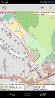
OSMfocus is an Android app (version 4.x or better required) and can show details of nearby objects from the OpenStreetMap database such that they can be compared with real world observations. Correcting errors or adding missing information to OpenStreetMap and thus getting it 'into focus' is the main purpose of OSMfocus. OSMfocus is not a map, navigation tool or OpenStreetMap editor.
Discrepancies between the real-world and OpenStreetMap are best observed on-site while memorizing details for later comparison with OpenStreetMap is usually difficult and with a good likelihood of missing the actual differences.
Screenshots
Display of data
OSMfocus shows key-value pairs as "=" and abbreviate one pair that occurs quite often, namely highway=* and name=* which is shown with a ":". Example:
residential: 'South Street'
lit = yes
maxspeed = 50
sidewalk = both
Way objects which has just a single key-value pair of type building=* are ignored when searching for nearby objects.
To make better utilization of screen space, the following keys are not shown:
- kms:*=*
- osak:*=*
- created_by=*
- addr:country=*
- addr:postcode=*
- source=*
You can set the number of info boxes in the settings to 2, 4, 8 or auto. In last case the number depends on screen size and orientation (landscape or portrait).
Permissions
OSMfocus use location services and network access permissions for downloading vector map data and background map tiles for your current location.
Userbox
Userbox which can be used on User pages in this wiki by adding {{User OSMfocus}}
| OSMfocus reviews OpenStreetMap data using OSMfocus. |
Links
See also
- OSMfocus Reborn - Author: Pieter Fiers / Platform: Android / Version: 1.0.1 (2021-04-03) / Install: Google Play / Source code: ubipo/osmfocus GitHub


