Pic4Review
| Pic4Review | ||||||||||||||||||||||||||||||||||||||||||||||||||||||||||||||
|---|---|---|---|---|---|---|---|---|---|---|---|---|---|---|---|---|---|---|---|---|---|---|---|---|---|---|---|---|---|---|---|---|---|---|---|---|---|---|---|---|---|---|---|---|---|---|---|---|---|---|---|---|---|---|---|---|---|---|---|---|---|---|
| Author: | Adrien Pavie | |||||||||||||||||||||||||||||||||||||||||||||||||||||||||||||
| License: | GNU AGPL | |||||||||||||||||||||||||||||||||||||||||||||||||||||||||||||
| Platform: | Web | |||||||||||||||||||||||||||||||||||||||||||||||||||||||||||||
| Status: | Active | |||||||||||||||||||||||||||||||||||||||||||||||||||||||||||||
| Version: | 0.5.30 Changelog (2024-03-04) | |||||||||||||||||||||||||||||||||||||||||||||||||||||||||||||
| Languages: | ||||||||||||||||||||||||||||||||||||||||||||||||||||||||||||||
| Website: | pic4review.pavie.info | |||||||||||||||||||||||||||||||||||||||||||||||||||||||||||||
| Source code: | https://framagit.org/Pic4Carto/Pic4Review | |||||||||||||||||||||||||||||||||||||||||||||||||||||||||||||
| Programming language: | JavaScript | |||||||||||||||||||||||||||||||||||||||||||||||||||||||||||||
|
Simple OpenStreetMap editor for contributing on missions using pictures. |
||||||||||||||||||||||||||||||||||||||||||||||||||||||||||||||
| ||||||||||||||||||||||||||||||||||||||||||||||||||||||||||||||
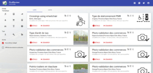
Pic4Review is an OpenStreetMap editor developed in JavaScript so that it is usable directly in the browser without plugins. It allows users to contribute using street-level pictures, the simple way.
You can try it at pic4review.pavie.info. Go to the mission list, choose one that interests you and start reviewing pictures!
Usage
To know more about how you can use Pic4Review, take a look at:
- Video tutorials
- Talk given at State of the Map 2018 (Milan)
- Slides from this presentation
- Demonstration video
Use cases
Pic4Review can be used either as a complement to a mapping party where lots of pictures were taken, or to contribute on an area with good photo coverage. Here are some examples of missions which can be easily done using this tool:
- Bus stops
- Fire hydrants
- Add fire_hydrant:type=* tags
- Accessibility to disabled people (on bus stops, crossings, paths...)
- Add wheelchair=*, tactile_paving=* tags
- Advertisements
- Bicycle parking
- Add capacity=*, bicycle_parking=*, shelter=* tags
And a lot more — just find what kind of features interest you! In the near future, it will be also possible to create new objects according to external data sources (you can help make this possible).
Functionalities
Review
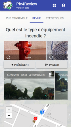
Pic4Review mainly allows the reviewing of features from OSM in order to complete their tags. By looking at pictures associated with each tag, you can see the details and contribute easily to add missing tags. For example, distinguishing the kind of fire hydrant, or if a bus stop has a shelter.
- Easy review features: pictures are automatically shown
- Simple interface for editing: symbol-based answers
- Fast contribution: in one click (and without tag knowledge), you can improve features
- Advanced editing: you can go back to standard editors (iD and JOSM)
- Export list of features which lack pictures in GPX or KML for easy ground survey
- Pictures are extracted from Mapillary, OpenStreetCam, Wikimedia Commons, and Flickr
- For each contribution, survey:date=* and picture tags (either mapillary=*, flickr=*, wikimedia_commons=* or image=*) is added automatically on the OSM feature
Statistics for gamification
To make contribution more fun, each mission has statistics about user contributions.
- Leaderboard: by mission and globally — see how you are ranked!
- Feature status: how close you are to completing the task
Mission creation
You can also create your own missions. Missions are defined by a theme and an area, like specifying toilets' wheelchair-accessibility in Paris.
- Data sources: you can use data extracted from OSM (via Overpass API) or use Osmose reports
- Integrated editor: you can either use classic editors or the integrated one, allowing fast contribution directly in the browser
- Duplicate mission: to create a new mission based on an existing one, you can duplicate it and simply change the contribution area
Technical
Pic4Review is developed in JavaScript, using various libraries (ReactJS, Leaflet, Material UI).
Contributions are welcome and you can help in many ways; there is no need to be a developer!
See also
#Pic4Reviewposts on Twitter - For project news and releases- Photo mapping - Technique for mapping in OSM using pictures
- Photo linking - Creating links between OSM features and geolocated pictures
- Pic4Carto - Tool for finding every street-level picture available in an area (and easy editing for OSM)


