Power generation/Hydropower
Hydropower activities convert water mechanical energy into electricity or mechanical rotating energy.
It has been used for a very long time, to begin with simple mills and nowadays in modern and industrial power plants.
As mechanical energy conversion systems, mills and power plants need constant and significant amounts of water to run.
Knowledge of such facilities is important for water management purposes, territory development or power capacity planning.
Mapping artificial watercourses is complementary to natural water ways as to create a global water network in OpenStreetMap.
OSM community had worked to improve tagging and documentation to describe a lot of different features about hydro power systems.
As of now, several tags are suitable to map watercourses that run between water catchment, storage, dams, power houses and releases.
This page is intended to give a complete view to mappers and how this data can be used around the world.
We deal about industrial facilities, often closed to public and inducing danger downstream of water catchments, dams or power houses.
Collecting information on ground should be done safely and with all due respect to local regulation/warnings. You must not get inside restricted or hazardous perimeters and this documentation won't ever expect you to trespass restricted perimeters.
Covered features
As a particular mapping project, we are mainly interested in mapping the following activities:
Hydroelectricity
Hydroelectricity is the most modern usage of hydropower.
We use to map hydroelectric power plants with power=plant + plant:source=hydro.
As often dispersed installations, they are mapped as relations involving the whole millrace and power components.
The watercourse and power equipment are mapped as to get a routable water and power networks in OSM with features:
- waterway=stream, waterway=river
- waterway=canal, waterway=pressurised
- natural=water
- man_made=pipeline
- power=generator
- waterway=dam, waterway=weir
- power=plant, power=generator
- power=line, power=cable
Knowledge of accesses and private roads sounds less useful and may be less verifiable as publicly undocumented.
Watermills
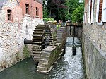
Watermills are simpler and still industrial facilities providing mechanical energy, often rotating, from a given water flow.
It is usual to describe buildings hosting the mill with man_made=watermill
You are encouraged to map the head- and tailraces that lead water and release it to natural environment.
How to map
Hydropower relies on sometimes complex and elaborated water infrastructure.
Even on ancient mills, it can consist in underground canals, aqueducts bridges, power houses inside caverns as to provide water the most reliable as possible.
Knowledge about such facilities can not only be found on ground but in public documentation, public archives.
It may be possible to survey usually closed places in operation during visits opened to public.
This documentation encourages to map watercourses and power paths only.
You can draw OSM ways along their paths and connect them to the existing OSM topology.
The resulting global water network will then become routable with appropriate routing engine.
Water control
Different methods change the water control capabilities of hydro power plants.
Such capabilities are mapped with two different practices: by drawing water reservoirs areas and completing plant:method=* on power=plant or generator:method=* on power=generator tags.
Run of the river
The simplest installation is following the run of the river: when the river is flowing, the turbines run and when there isn't enough water (physically or regulatory), they stop.
It's not a controllable method and the plant can only generate power when water comes to it.
Such infrastructures don't have upstream water reservoir and penstocks are fed with water diverted from a river or a stream.
Power plants are tagged with plant:method=run-of-the-river and generators with generator:method=run-of-the-river.
Water storage
On more elaborated installations, water can be stored upstream of the power plant as make it controllable. A valve is opened to output electricity or closed to stop it.
The reservoir is drown as the widest area the water can cover with natural=water + water=reservoir.
Power plants are tagged with plant:method=water-storage and generators with generator:method=water-storage.
Water pumped storage
The most elaborated installation can use turbines as propellers and generators as motors to reverse the flow of the water and pump it back in the upstream reservoir.
The reservoir is drown as the widest area the water can cover with natural=water + water=reservoir.
Power plants are tagged with plant:method=water-pumped-storage and generators with generator:method=water-pumped-storage.
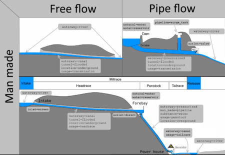
The millrace
The millrace comprises the whole watercourse between intake and release. It is a special kind of artificial Waterways.
It is composed of different sections where water flows at different regimes, open or pipe flows.
Many hydraulic equipment can be installed around the watercourse depending on environment and power needed to be produced by the infrastructure.
- It can be very short, included in big dams provided with power houses at their bottom (see power houses section for an example).
- It can also be very long, carrying water from mountains to power houses down the hill kilometres away.
The water can be carried through several transmission canals, sometimes underground in pipeline or tunnel=flooded, prior to be lead toward the intakes feeding the power house.
It mainly depends on the spread of the collected watershed and the elevation to deal with. It makes each hydropower facility unique.
Even if water flow is often controlled when entering any artificial waterway, those are supposed to to be permanently flooded.
You'll find water most of the time inside, even if the mill or power house is out of service.
As a consequence, it is discouraged to add intermittent=yes on any section of the millrace.
You may find further and more detailed mapping guidelines on every features pages mentioned below.
Dams
OpenStreetMap feature: waterway=dam
Dams are often highly visible features to be mapped on OSM.
They are intended to impound water flowing in a river or coming from a given watershed.
There are very small dams and very big ones too.
Depending on the size of the barrier it can be mapped as a simple waterway=dam way across the barred waterway or an area covering the footprint of the dam.
Dams regulate the amount of water that are processed by heard works (see below).
Valves (often valve=gate) are installed to retain water from natural course. They can be closed on opened on demand during dam operation.
Here are some mapping examples:
1090278038
 1090278038
544156138
 544156138
Upstream and downstream surroundings of dams may be dangerous places to access.
Navigate by boat next to a dam can lead to injuries or drowning and access to immediate downstream may expose you to sudden flood.
Always pay attention to directions and warnings to remain safe at all time.
Head works
Head works are the places where water is diverted from the natural field and processed toward canals or penstocks.
They are often located beside a dam but are completely different installation as well, composed of several components.
They often include inlet=screen and grit remover as to prevent sand, rocks to get into tunnels or canals.
Each intake where the water enters the artificial duct are mapped as nodes linking natural stream or river and artificial watercourse. Those nodes are tagged with appropriate inlet=*, inlet=screen if applicable.
Mapping is focused on water courses and buildings seen on ground.
It is recommended to document inlet=*'s floor elevation with ele=*.
The downstream headrace or penstocks operation depends a lot on how head works are designed.
You have to pay attention to the minimum water level required, to know if air can get inside a tunnel starting from the head.
If no air can't get in, any downstream tunnel or pipeline will get waterway=pressurised.
Here are some example situations:
847331658
 847331658
Headraces
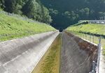
Headrace waterways are intended to carry water from head works to penstocks.
Every section of such watercourses are tagged with usage=headrace.
It includes surface canals and underground tunnels with very diverse designs.
Tunnels may operate both free flow or pipe flow depending on feeding head works.
In case of very shorts millraces, mainly when the powerhouse is installed inside the dam, there is no headrace and pressurised penstocks are directly connected to intakes.
Headrace canals or tunnels may be occasionally found accessible while on surveys, for instance during inspection or maintenance.
However, the nominal water flow can be restored at any time and you must not get inside tunnels or cross canals.
You must pay respect to directions and warnings to not put yourself at risk.
Surge tanks
As great amount of water may run inside pressurised headrace tunnels, a surge tank is required to protect the underground structure from damages resulting from hydraulic hammer force.
Such tanks may be huge shafts of hundred meters depth. They are designed to allow a given water volume to expand and reach equilibrium without any damage on upstream structures.
They should be mapped:
- As a node placed on the waterway itself, tagged with pipeline=surge_tank, optionally diameter=*.
- An area around, with man_made=shaft or man_made=chimney and barrier=* depending on what you see on ground. Area must not get pipeline=surge_tank as it isn't connected to waterway.
Surge tanks are usually built near and upstream of valves responsible of hammer force they are supposed to disperse.
You will find shafts/chimneys near of service buildings hosting valves, linked by the waterway. Access to shaft isn't possible in operation as the tank is filled with water.
Surge tanks may be hazardous places: depending on the hammer force to disperse, particularly during emergency stops, water may rise over the shaft/chimney and overflow around.
Stay away from them, never ever fall inside.
Always pay attention to directions and warnings to remain safe during surveys.
Forebays
Forebays are useful to collect water from free flowing headrace canals to send it into pressurised water courses and ensure no air can go downstream.
These are particular kind of water reservoirs installed between free flowing headraces and penstocks.
You may find them outdoor or self contained in a building=service.
Their design usually make them slightly deeper than the upstream canal, enough to maintain the water over the penstocks intakes.
A supplementary trash rack can be installed as to prevent anyone or any object to be sucked downstream.
Forebays usually come with their own spillway as to allow water to get out the upstream canal in case of valve closing downstream.
No forebays are required to pressurised headraces to penstocks and the spillway would be replaced by a surge tank.
Penstocks
Penstocks are always pressurised water pipelines.
They are intended to direct head water toward turbines at the highest possible pressure.
Every section of penstocks are tagged with usage=penstock.
They can be directly connected to intakes (located underwater) or fed by headraces watercourses.
Penstocks are usually locked by head valves, right after the connection to their upstream source. Valves are located in the same room as forebay or in a dedicated building=service beside.
Penstocks can be visible going down hill or dug directly into mountains, often like vertical shielded shafts.
Shielding with tubes makes them look like actual pipelines and man_made=pipeline remains suitable.
Tailraces/discharges
Once processed in the power house, the water should be released in the natural environment.
Discharge or tailraces watercourses are built between the bottom of any generator in the power house and an outfall.
Such watercourses are tagged with usage=tailrace.
Similarly to headraces, tailraces may be surface canals or underground tunnels with various designs.
Tunnels will be operated free flowing (waterway=canal) or pressurised (waterway=pressurised), depending on their outlet location.
Despite tailraces canals / tunnels are supposed to be operated at low pressure since they are located downstream of power houses, they remain highly dangerous places.
Power houses can be operated without notice and released water may surprise you. You must not get inside canals or stay next to outlets.
Always pay attention to directions and warnings to stay safe while on survey.
Power houses
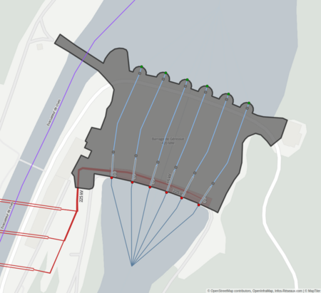
The power houses are intended to host power=generators to generate electricity.
They contains some other equipment as safety and control valves.
They are linked to (or host) a substation=generation power=substation like any other power plant.
Power houses are usually buildings, built outdoor or inside caverns, and are different from power=plant.
They are mapped with building=industrial.
Hydropower power=plant are usually type=site relations involving the whole millrace, dams, power houses for a given infrastructure.
See 3148211![]() 3148211 vs 233803622
3148211 vs 233803622![]() 233803622 for example.
233803622 for example.
Valves
The shutter valves located in (or near of) the power house are subject to the highest pressure of the facility, since they are next to the power generator.
They are mapped with pipeline=valve on a node of the penstock pipeline's way.
High head valves are often valve=ball to bear the upstream pressure.
Low head valves can be valve=butterfly.
When surveying, you may look to what is used to change the valve's state and add actuator=hydraulic_cylinder or actuator=electric_motor.
Generators
Hydropower generators are mapped as nodes connecting upstream penstock pipeline and downstream tailrace discharge canal.
They always have power=generator + generator:source=hydro.
You can also add generator:method=* and generator:type=* if you are aware of it.
Turbines
OSM currently doesn't have tags dedicated to turbines. It is merged with power generator for sake of simplicity. Not to mention turbines are sometimes located right under the generator, making harder to describe them on overlapping nodes.
A proposal remains to be written on that topic, to provide more elaborated tagging for turbines and diverse situations (several turbines on single generator...)
Reference works
Some proposals has been reviewed since 2013 on that particular topic.
- Power generation proposal.
- Hydropower water supplies proposal, refining hydraulic features tagging.
- Reservoir proposal for water storage basins.
- Valves proposal, applicable to hydropower facilities.
- Pumping proposal, including some elements for pumped storage hydropower.
- Inlets and outlets proposals.
See also
- Waterways mapping documentation
- Water management documentation
- Power networks mapping project

