Proposal:Disc golf course 2025
| Proposal:Disc golf course | |
|---|---|
| Proposal status: | Draft (under way) |
| Proposed by: | Freephile |
| Draft started: | 2025-03-16 |
Preamble
As an avid disc golfer, mountain biker, motorcyclist, local trail builder and MediaWiki hacker, I have a strong interest in OpenStreetMap. I know a lot of people have done a ton of work over time to get things where they are. In this proposal, I hope to concentrate the effort and bridge the missing links that would benefit all projects and people involved. So, I hope the community will rally around this proposal and offer wisdom, strong shoulders and guidance to get disc golf courses mapped in OSM.
Proposal
Given that there are more than 16,000 disc golf courses worldwide with over 1,165 new courses registered on UDisc in 2024 alone[1], OSM should fully support mapping, tagging, and rendering Disc Golf Courses. This proposal aims to achieve that with 3 goals:
- Render disc golf courses on the map.
- Expand and improve documentation on-wiki.
- Enable mappers by spreading support and best practices throughout the editors (tooling) that mappers use.
All of these goals will ultimately improve the user experience.
Because disc golf is similar to traditional 'ball' golf which is already supported quite well in OSM, there is ample precedence to draw from. However, there are differences between ball golf and disc golf. From a mapping perspective, disc golf has some similarities with mountain biking, hiking or climbing. So it is important to capture the attributes particular to disc golf. And even if support for traditional golf is not perfect in OSM[2], we will not allow perfection to be the enemy of the good. Good support for disc golf will serve all users and stakeholders.
Right here in the wiki, at the Disc golf article, you can see there have been many prior conversations on this topic. Although most of the disc golf discussions are quite old, there are many related technical discussions and best practices regarding things such as bike routes[3]; editor presets and so on... evolving to this day. So we hope to distill, summarize and give clarity to prior concerns, or uncertainty as well. Ultimately, the wiki documentation is the canonical reference, so that is where status and best practice info needs to reside.
Why do this?
On the Disc golf talk page, people have asked for this proposal or its result. This is also why expanding and refining documentation is central to this proposal.
Goal 1: Render on the map
Part A: render Courses
Regardless of the underlying properties and tags of the feature, the critical first objective is to have disc golf courses rendered visibly as a Point of Interest (POI) so that they
- can be seen browsing the map
- found in search
- a user can navigate to that POI as a destination.
Disc Golf Courses need to be rendered on OSM as a Point of Interest (POI) like so many other POI. A notable difference is that traditional golf courses are closed polygons (areas) whereas disc golf courses are points (nodes). The single point that represents a disc golf course is then associated to all the other elements of the course through relations - and we'll address that in Part B.
Part B: render Elements
At sufficient zoom (17+) individual disc golf course Elements should be rendered as well. These elements are the tee pads, baskets, and the "lines" that make up the holes of the course. There are additional elements to consider as well such as paths between holes or the location of a "lost and found" dropbox.
Goal 2: Increase & improve Documentation
One of the key historical issues is that the documentation was inadequate. The wiki page at Tag:leisure=disc golf course is currently in pretty good shape, with key improvements by Negreheb and others. We'll identify improvements, and make them.
- Tag:sport=disc_golf
- Was updated to follow Tag:sport=golf
- The wiki data description (which populates the infobox etc.) of that item appears to be incorrect. At the very least it seems to miss the point by not really describing the item, but most naming multiple rare synonyms. A discussion was started on the wikidata item about the possibility to simplify the description.
- The Key:sport page needs to be updated to include
sport=disc_golfin the table. (There are approx. 3500 uses of sport=disc_golf) - Clarification needed: On the Tag:leisure=disc golf course wiki page, it says not to use sport=disc_golf (apparently because it is implied). Where is this underlying assumption?
- Tag:leisure=disc_golf_course
Some tags that should be used in combination- Tag:disc_golf:length=* (or perhaps better: Tag:disc golf:course_length) Use to annotate the overall length of a course.
e.g.
disc_golf:course_length=4445 ft(note: on individual holes, "length" is marked with the dist=*) - Tag:highway=path Use for foot paths and cart paths between holes.
- Tag:highway=service for actual service roads (e.g. where DPW department has access, but not for player vehicles)
- Tag:disc_golf:length=* (or perhaps better: Tag:disc golf:course_length) Use to annotate the overall length of a course.
e.g.
- tagInfo for disc_golf
TagInfo shows 16 values for this key. Only 3 are currently enumerated on wiki with their own pages. We should officially expand the visibility of wanted values while also documenting discouraged values.- Tag:disc_golf=hole
- Tag:disc_golf=tee
- Tag:disc_golf=basket It would be neat if we could figure out a way to render basket nodes with a 10m radius circle. This would be to illustrate the "Circle One" of disc golf. Circle one is equivalent to the green of traditional golf. When your disc lands there, you're "inside the circle". This might be achieved by applying 'highway=turning_circle' and 'diameter=10 m' to basket nodes. I'm unsure if these tag combinations would actually render a 10m circle on the map. Maybe we'd need to create new handling of svg circle or path properties. Another example of how this is done today for other features is the JOSM Building Tools plugin that allows you to quickly draw circular buildings.
- out_of_bounds
- mando - A mandatory route or 'mando'[4][5] is normally a vertical plane perpendicular to the fairway. The mandatory route avoids entering the plane defined by the mando marker. Typically, that marker is a tree (with signage) that the player is forced to throw around on one side. Sometimes it could be a double mando (hit the gap between two trees) or even a triple mando (hit the tunnel defined by a framed structure).
- mando_left - discouraged. Use 'mando' since the hole will show the mandatory route.
- mando_right - discouraged. Use 'mando' since the hole will show the mandatory route.
- drop_zone - Used for water hazards, and missed mandos.
- island - The opposite of 'out_of_bounds'. An island is an area that is marked exclusively 'in bounds' and is typically an area that includes the basket.
- dropbox - Location of lost and found. For returning discs found while playing. It might be helpful if there was a way to indicate additional information such as contact info, an online resource, or establishment that manages the lost and found for those seeking lost discs.
Goal 3: Enable mapping of disc golf courses
It should be possible, and even easy, to map a disc golf course in OSM, using iD, JOSM, Rapid and other editors. This is achieved by combining support in OSM of the features and tags plus Outdoor mapping. With a sufficient set of tags supported in OSM, mappers should be able to readily convert GPX tracks into detailed course maps - starting with the main marker for the location of the course.
It is important to recognize that disc golf courses normally have multiple "layouts" in a single course. Disc golf has color-coded skill levels, just like traditional golf, or belts in karate. Typically the skill-based layouts correspond to distance using separate tee pads for short, intermediate, long and pro. But where space and budget allows, courses also use different pin positions (baskets) to offer variety.[6]
Beyond the OSM (data) project, it will be important to promote and extend these features into the most common editors as presets.
It is typically very hard, or nearly impossible to do "arm chair" mapping of disc golf courses because the features are in wooded areas. Nonetheless, a dedicated arm chair mapper should be able to try mapping the missing Dexter Disc Golf Course in Dexter State Recreation Site using the course map provided on their website.
Visibility hack: (note to mappers) If you know that some non-rendered tags have been added to OSM, you can quickly see them on the map by enabling the "Data Layer" overlay. On any map, using the Layer URL parameter &layers=D querystring parameter should make the data visible.
Ancillary Goals
Some ancillary or indirect goals will be achieved through the implementation.
- Provide clear guidance on mapping
- Avoid misuse or mistagging
- Clean up historical usage - at least provide clear guidance to mappers/editors how to properly tag features.
Non-goals
Nearly every disc golf course has "tee signs" at each tee pad. These depict the hole to be played and provide guidance about distance, par, obstacles and boundaries. There is also normally a large-format "course overview" or "Info Board" sign, billboard or kiosk depicting the course facility and extent plus amenities. These maps are not suitable for mapping and/or rendering in OSM.
Special purpose directories and applications exist to classify, search and filter disc golf courses. These applications, such as UDisc, require a larger schema or vocabulary than would be appropriate for OSM. So, while it would be nice to be able to see the type of disc golf baskets are use at a given course, this level of detail is probably inappropriate for the OSM database. For example, this is some of the detail that UDisc tracks:
holes: 18 holes
tees: concrete, dirt, brick/pavers
baskets: Mach VII
facility: mixed use
course type: public park
dog friendly: yes
cart friendly: yes
restrooms available: yes at hole 11
drinking water available: no
stroller friendly: yes
year established: 2022
Rationale
There is already support for this in various OSM editors, we just need to lead the effort in terms of rendering the work of editors and giving mappers guidance on how to get the job done. In this way, mappers, developers and users can all benefit from the coherent support for the sport.
Support for tagging in iD Editor
- There is already support for tagging in the iD editor.
- The preset for disc_golf_course was added in 2020
- This merged pull request (PR) added presets for Disc Golf Hole, Disc Golf Tee, and Disc Golf Basket to the iD editor in Jan 2022.
- Bug: the iD Editor needs an icon for 'disc golf tee' because currently the basket icon is used for tees and baskets!
- Defining and documenting standards and best practices for disc golf will enable the project to adopt these into their existing presets.
Support for tagging in JOSM
- There is already support for tagging in the JOSM editor - both 'presets' for tagging and 'styles' for rendering locally in the editor.
- This preset was developed in 2018
- Provides support for the tag
leisure=disc_golf_course - Provides support for tags Disc Golf Hole, Disc Golf Tee and Disc Golf Basket
- Provides support for the relation
type="disc_golf_course" - This style (v0.8 developed in 2024) adds icons for tee and basket and other features. See the Community discussion for more visuals.
- The icon for tee would be a very good icon to use generally for rendering a disc golf tee unless a simple rectangle is preferred.
- Bug: It seems to require 18 holes in order to create a proper relation - but many 9-hole courses exist and some might only have 2 or 3 baskets.
- Bug: The preset should ideally be grouped under 'facilities'->'leisure' or 'sports'
- Bug: Two of the presets have almost identical names: 'Disc golf course' and 'Disc Golf Course'. The first is for 'relation, closed way, node' and tags leisure=disc_golf_course. The latter is for a relation, tagging it 'type=disc_golf_course' but seems to require that there be 18 ways with role=hole for it to apply successfully.
- Bug: The CSS for the styles in the Editor are static pixel-based instead of em or relative. In other words, then look fine when zoomed all the way in (high zoom), but they look terrible when zoomed out since they appear monstrously big - obscuring everything else nearby.
Support for disc golf in the Beautified JOSM icons from Simon Poole
- Support for disc golf (an icon) was added in Sep. 2023
- They are looking for more icons as of Feb 2025
Tagging
Tag instructions in brief
- Add a node (not an area) to represent the course.
- Place the node at the course info sign. If none exists, then by the first hole.
- Tag the node leisure=disc_golf_course and sport=disc_golf
- Add ways for each hole.
- Make the beginning node of the way the 'tee'.
- Make the ending node of the way the 'basket'.
- Add a relation that groups the holes for a particular layout.
See the Proposal:Disc golf course 2025#Tag Schema section below for the full set of tags used in an 18-hole disc golf course.
Tag Schema
According to the current de facto standards and discussion in this proposal, the tagging for a course would look like this:
node01 (primary node at the location of the info sign)

	leisure=disc_golf_course
		sport=disc_golf
		name=Weare-Merriman Park Disc Golf Course
		disc_golf:course=18_hole
		disc_golf:par=54
		disc_golf:length=5527 ft
		addr:housenumber=121
		addr:street=Weare Road
		addr:city=Seabrook
		addr:state=NH
		addr:country=US
		addr:postcode=03874
		operator=Town of Seabrook, NH
		website=https://seabrooknh.info/town-departments/recreation/
		website:udisc=https://udisc.com/courses/weare-merriman-park-disc-golf-course-8REj
		opening_hours=24/7 - Accessible without restrictions
		fee=no
		contact:*=*

way01
	disc_golf=hole
	role=hole
	ref=1
	par=3
	dist=302 ft
	node[origin]
		disc_golf=tee
        tee=white
		surface=concrete
	node[end]
		disc_golf=basket
; draw/map all the holes
way02
way03
way04
way05
way06
way07
way08
way09
way10
way11
way12
way13
way14
way15
way16
way17
way18
	disc_golf=hole
	role=hole
	ref=18
	par=4
	dist=454 ft
	node[origin]
		disc_golf=tee
        tee=white
		surface=concrete
	node[end]
		disc_golf=basket

; a relation to associate holes 01-09 plus miscellaneous features and ways with the course node
relation01
	type=disc_golf_course
	name=front 9

; a separate relation to associate holes 10-18 with the course node into a 'layout'
relation02
    type=disc_golf_course
    name=back 9

; miscellaneous nodes
; a mandatory route is a vertical plane that must not be entered
node
	disc_golf=mando
; a drop zone is like a temporary tee
node
	disc_golf=drop_zone
    disc_golf=tee (renders the drop zone as a tee)
; a practice area contains baskets which are not part of any hole
node
	disc_golf=putting
	disc_golf=basket (for rendering)
	(no ref - because it is not labelled)
; a drop box is where found discs are deposited
node
	disc_golf=dropbox
; Additional ways
; foot paths illustrate how to get to the next tee pad
way19
	highway=path
way20
	highway=path
; draw/map all the paths between one hole (basket) and the next (tee)
way21
way22
way23
way24
way25
way26
way27
way28
way29
way30
way31
way32
way33
way34
way35
way36
; Miscellaneous Ways
; an out of bounds (OB) area is defined by a line or object (e.g. fence)
way
	disc_golf=out of bounds

; problem tags
; fairways are generally not found in disc golf and complicate the element recommendations by introducing areas.
fairway
; islands are rare in disc golf and introduce the complexity to map a hole as multipolygon areas.
island
Here is a summary table of tags with links to taginfo etc.
| Tag | documentation | taginfo | stats summary | ||||||||||||||||
|---|---|---|---|---|---|---|---|---|---|---|---|---|---|---|---|---|---|---|---|
Tag:leisure=disc golf course
|
Tag:leisure=disc golf course | ||||||||||||||||||
| Key:disc golf | Key:disc golf | https://taginfo.openstreetmap.org/keys/disc_golf#values | 25,065 objects | ||||||||||||||||
| |||||||||||||||||||
Notes on Tagging
For compatibility with OsmAnd[7], sport=disc_golf should be used to identify the POI for the course. This enables one to navigate to the course.
Holes
For Holes, the tag 'par' is favored 3.5x over 'disc_golf:par', so why is is 'alternate' instead of the standard? Par comes from the world of ball golf and means the exact same thing in disc golf, so why invent another tag? Just use 'par' to tag and describe disc golf holes like people already do.
Examples
Visuals
(click the left and right angle brackets to navigate this screenshot gallery)
- screenshots

Example rendering of a disc golf course marker on a map. The symbol is the recognizable shape of a "target" - called a "basket" in disc golf.
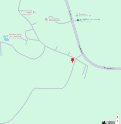
Kastelholm DiscGolfPark shown on Google Maps - map base layer. Google Maps uses an undifferentiated marker.
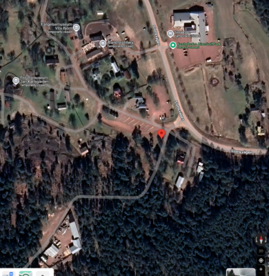
Kastelholm DiscGolfPark shown on GoogleMaps - sattellite base layer. The sattellite base layer is used here just to show the extent of forest in the land area. 7 of the 9 disc golf holes are in the woods.

Course overview signage Artistic signage exists for nearly all disc golf courses. These signs are almost universally located in the vicinity of the parking and hole one. The exact location of this sign should be the location of the 'course'. Good support for disc golf mapping and rendering in OSM will help course designers create this type of artistic signage. Mappers can use these "info board" signs to create, verify or enhace OSM features.

This screenshot illustrates detail rendering of the collection of holes that make up a complete disc golf course. This example is unusual in that there are only nine baskets (targets), with 18 tee pads to create a full "front nine" plus "back nine" course layout. At the same time, it illustrates the point that there are various combinations of layouts in the disc golf world. More on that in the discussion of tagging. In this application, tee pad number one is highlighted (blue) by virtue of clicking on the first tee pad symbol - a rectangle. The metadata for that object is then displayed in a balloon. The corresponding basket for hole 1 is also highlighted (orange) by the mouse pointer hovering over it. If the basket is clicked, a balloon appears with metadata for that object (name, layouts, basket type, hole #, active status). The fairway line for hole one is depicted as a slightly opaque path from the tee to the basket with a hole number as a label. If that label or path is clicked, then a balloon appears displaying the metadata for that object ("Fairway 1", Active, F9 -> F&B, Hole 1 284 ft Par 3)


See #iconography for discussion of icons and icon sets.
Disc Golf Courses
- Skatås discgolf gul bana (OSM 913917) relation with all the holes tagged as well - done properly except that there should also be a primary node for searching and navigation. It currently is not rendered unless you specifically select the feature. Also, because the 'name' is attached to the relation, you can not find this feature by searching for it. For all intents and purposes it does not exist on OSM (unless you know it's there.)
- Maple Hill Not really mapped at all in OSM, however it is the #1 course in N. America and is a dedicated facility with multiple layouts of 18 holes; and hosts professional tournaments of the PDGA each year. Udisc w/ Reds selected OSM Node:Maple Hill Disc Golf tagged with
access=customers fee=yes leisure=disc_golf_course name=Maple Hill Disc Golf sport=disc_golfis not rendered. - Amesbury Pines Udisc PDGA Course directory - not mapped in OSM, but it's local so User:Freephile could map it.
Bad Examples (avoid)
The U.C. Santa Cruz Disc Golf Course serves as a poor/contra example of proper tagging.
- The primary node is type 'route' - incorrect. The course should identify a particular point where the course signage / entrance is (usually very near hole 1). But how are the relationships supposed to be made? Routes ARE used for walking and hiking routes. Good info on the wiki page for Relation:route
- Each hole is a way (correct), but the endpoints (nodes) are each type 'basket'. One of the nodes for each hole should be a 'tee'.
Lac Kir Udisc Google Maps OSM Way: Disc Golf Lac Kir - this is a closed polygon with 26 nodes defining the perimeter of the course BAD
Rendering
- At zoom 0-14, nothing related to disc golf will be rendered - it's an insignificant detail on the larger map.
- At zoom 15-17 the icon (and any label if present) is shown.
- At closer zoom (18, 19), individual disc golf course elements are rendered in addition to the label and icon.
These rules for rendering are essentially the same as regular golf, except that for some reason the golf icon and label disappear at zoom 18-19. Since a disc golf course is a node element, I think the icon and label should persist.
At zoom 18 or higher, the actual course features of numbered holes, tee pads and baskets should be rendered to show the layout of the course. Unlike golf, disc golf 'fairways' should not be rendered as areas (and not tagged as areas) because they rarely exist as well-defined areas and would therefore be very difficult to tag as such. In disc golf, a fairway is basically a line through the woods, like a foot path. Even at dedicated facilities, used for the Disc Golf Pro Tour, or disc golf courses built at traditional golf courses with well-defined "fairways", it is not inconsistent to map these holes as a simple path from tee box to basket.
Comparison to Traditional Golf
We can look at how traditional golf courses are rendered as a frame of reference and to inform how disc golf courses could be rendered.
Golf rendering in OSM

item 301867063 is the Amesbury Golf and Country Club, a feature of leisure=golf_course which is rendered as an area shaded in orange, with an icon consisting of a pin flag with a stick figure swinging a golf club (See screenshot). There are 6 tags for this feature (ignoring the 60 nodes to define the area; and all the course elements):
golf:course=9_hole
golf:par=35
leisure=golf_course
name=Amesbury Golf and Country Club
phone=+1 978 388 5153
website=https://www.amesburycountryclub.com/
Differences with FR tile server
'Golf de Lesigny' is perhaps a good example to illustrate how the French tile server[8] has modifications from OSM-Carto. In particular, there are differences in how zoom is handled in osmfr versus Osmcarto(Mapnik). In Osmcarto, the fairway elements are still rendered when you zoom out. And, conversely even when zoomed in, the alternate tee locations (short, intermediate) which are visible in osmfr are not rendered in Osmcarto. Compare these direct links osmfr tile server at zoom 16 vs. OSM at zoom 15, or compare side-by-side using the BBBike compare tool.
Golf rendering in OsmAnd
This is how a traditional golf course is rendered in OsmAnd

Code
The code for rendering disc golf courses would be similar to the rendering support for traditional "ball golf" courses in OSM Carto. OpenStreetMap-carto added rendering for golf=* in this commit in 2021, closing out issue #661. That commit shows that we'll need to add a disc_golf_basket.svg (See Iconography section), a disc_golf.mss (see golf.mss), and edit project.mml
Outside examples
UDisc - the leading app for disc golf - shows a basket on a map (See screenshot with basket symbol highlighted in orange.) In the map panel, the mouse cursor changes from hand to pointer when you hover over the basket symbol. In the search results panel, hovering over a result item highlights the entire item, and the corresponding map element icon changes to orange.
The PDGA Disc Golf Course Directory website shows the following metadata about a course. The thumbnail map insert links to Google Maps by lat/lon coordinates with an icon marking the course location.
---
Course type: Permanent
Total holes: 18
Year established: 1997
Target-type: Baskets
Tee-type: Pavers
Cart-friendly: Very
Course Length: 5,233 ft
# Hole length summary would be calculated data from hole entries
Hole lengths:
  - under 300 ft: 10
  - 300 - 400 ft: 8
  - over 400 ft: 0

Description: |
  Most holes set in a tall pine forest.
  4 holes play over beautiful ponds.
  Dual tees.
  Adjacent to playground.

First Tee: (42.852478000000,-70.940500000000)
Parking Lot: (42.852340000000,-70.940957000000)
Links:
  - Course Web Site
Contact:
  - Name: John Doe
  - Phone: 978-555-1212
  - Email:
Iconography
We need an icon that identifies a disc golf course (unless we use a simple marker). The most suitable icon would be a 'basket' icon. Several examples of freely licensed icons are given in the table below.
We also need an icon for disc golf tee. The icon from JOSM Styles would be a great candidate unless a simple rectangle is preferred.
| # | Icon | Original | Source | License | Commons |
|---|---|---|---|---|---|
| 1 | File:Disc golf basket-temaki.svg | Rapideditor | CC-0 | ||
| 2 | disc-golf-basket.svg | Game-icons.net | CC-BY-3.0 | commons:File:Disc-golf-basket_-_Delapouite_-_game-icons.svg | |
| 3 | disc-golf.svg | Tabler icon | MIT licensed | commons:File:Tabler-icons_disc-golf.svg | |
| 4 | park-icon-disc.svg | Oregon State Parks | Copyright inelligible / Public Domain | commons:File:Stateparks.oregon.gov-park-icon-disc.svg | |
| 5 | sport_sport_disc_golf_day.svg | OsmAnd Web Marker (the POI marker icon used in the OsmAnd Web app) | Apache 2.0 | ||
| 6 | disc_golf.svg | Simon Poole beautified JOSM icons | CC0 | ||
| 7 | tee.svg | JOSM Styles DiscGolfCourse | GPLv2+ |
My personal preference is for the basket icon #1 in the table. This icon is already the icon displayed in the iD editor when you have a relation member role=hole, and you edit that feature[9].
Clutter concern
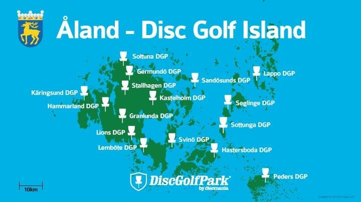
Åland (an autonomous territory of Finland), also known as "Disc Golf Island", has the highest concentration of disc golf courses per capita anywhere in the world. This Åland DGP Map [10] shows what the highest possible density of courses looks like on a 10 km (6.2 mile) scale. At that zoom level, disc golf courses would not be shown on the map. But, at high zoom, they can be shown without cluttering the map.
Features/Pages affected
Key:disc golf:course
- Created Key:disc golf:course similar to Key:golf:course.
Tag:Leisure=disc golf course
- Update the illustration (File:Disc golf field.png) used on the Tag:Leisure=disc golf course page according to any revision in recommended and supported elements.
- And update the Map Illustration Key table for the image - adding descriptions for any additional elements and improving existing descriptions. Here's what an updated table could look like:
Map Illustration Key Feature Element Description Number hole 
A hole is represented by a way along the standard playing path from the tee to the green. Should include ref=* to indicate which hole this is. 1 tee 
The point where play begins on a disc golf hole. This is the beginning node of the way for the hole. 2 basket Ending point of a disc golf hole. This is the last node of the way for the hole. 3 mando
(Optional) An object (usually a tree) that marks the boundary of a vertical plane that must NOT be entered (either forward or backward). A mandatory route restricts the path the disc may take in the process of playing a hole. The restricted plane is a vertical plane marked by one or more objects or other markers which define the edges of the space. If there is a double mando, mark two nodes (not a way). A triple mando can not be mapped in 2-D space.
4 out_of_bounds (Optional) An out-of-bounds (OB) area is an area designated by the Tournament Director from which a disc may not be played, and within which a stance may not be taken. The out-of-bounds line is part of the out-of-bounds area. Any area of the course that is not out-of-bounds is in-bounds. 5 fairway 
 Propose to drop support for tagging and rendering 'fairways'
6 island Propose to drop support for tagging and rendering 'islands'7 drop_zone
(Optional) A special teeing area that is available for an OB throw, missed mandatory, lost disc, or an abandoned throw. Map as a node since it is a specific spot similar to a tee.
8 putting
Practice area. Do not use 'putt_range' or 'putt_training'. The practice area will include one or more baskets and possibly a net for throwing into. dropbox
Location of lost and found. For returning discs found while playing. clubhouse The building dedicated as a clubhouse where fees are paid or maybe a shop is located. Always tag building=* for the building itself.
Tag:disc_golf=hole
- Update Tag:disc_golf=hole; namely to recommend dist and par (reflecting the requests on the discussion page)
- Add 'role=hole' as a recommended tag (I'm not sure whether this needs to be tagged only in the context of a relation, or if it can be applied at the element level.)
Tag:disc_golf=tee
- Updated Tag:disc_golf=tee to add tee=* in "Tags to use in combination" section.
- Also updated surface=* examples with actual recommended values.
Key:dist
Others
Create pages for any red links in the table above; ie.
Tag:sport=disc_golf
Clarify how implied tagging works. What does it mean? Can the content on this page be improved?
Disc golf
Update the Disc golf page to reflect usage guidelines.
External discussions
Prior proposal
There was a longstanding proposal Proposal:Disc_golf_course started in 2011 (abandoned in 2016)
Some good work came out of that proposal. However, reflected in the fact that it was abandoned, there is more work to be done.
There is a much more recent community discussion at How to map a Disc Golf Course (Proposal) (started 2023).
This proposal addresses any previous issues and carries the work forward with fresh perspective plus adds the benefits that the passing of time has given us.
Render efforts
Render some disc_golf features (similar to analagous golf=* features) is an issue (#3766) in openstreetmap-carto, initiated in 2019, yet still unresolved. This proposal aims to address any concerns raised there so as to ensure a successful pull request (code contribution) to the project for default rendering in OSM.
Answering / addressing points from the issue.
The documentation for these tags is still limited and needs improving.
Agreed. Documentation needs to be improved and expanded. It already has[11], and is receiving renewed attention and expansion.
From the proposal: "[disc] golf is usually in a park or wood and only in special cases at a single-use area" - so an area is problematic, but where would a node be placed?
The node should be placed at or near the first tee pad. At the entrance to the course. There is almost always a marquis (info) sign at the parking lot and that would be the perfect point.
Should disc golf courses be mapped as areas or nodes? What defines the borders of an area used for disc golf?
Each course is a collection of holes (typically 9 or 18 holes) made of nodes and ways. The border of the area is usually not relevant due to shared use, public spaces.
The old proposal is from 2011 and has not been updated since 2012.
It would be difficult to develop a good rendering without clear tagging and documentation
Absolutely, and hence this proposal.
Differentiating sport infrastructure (like pitches) by type of sport (#844)
OSM-carto Issue #844. This issue is addressed by this proposal because this proposal takes the stance that disc golf courses are not closed polygons. There is no pitch to differentiate. Disc golf is not specifically mentioned in issue #844. It was only a concern for the pre-existing disc golf courses in OSM that people had (inadvertently/incorrectly) tagged as enclosed areas. As of 2025-03, there are zero leisure=pitch in combination with sport=disc_golf
Comments
Please comment on the discussion page.
References
- ↑ https://udisc.com/disc-golf-growth-report
- ↑ https://github.com/gravitystorm/openstreetmap-carto/issues/4863
- ↑ US route relations discussion in community Nov 2024
- ↑ https://www.pdga.com/rules/official-rules-disc-golf/80401
- ↑ https://udisc.com/blog/post/disc-golf-rules-explained-mandatories-mandos
- ↑ 6.0 6.1 The PDGA defines at least four skill levels calculated by player rating: red 850+, white 900, blue 950, and gold 1000. There are actually 7 total skill levels.
- ↑ https://github.com/osmandapp/OsmAnd-resources/blob/dd575efb5aa4ec7e359bb50e8dc6de7c358ff258/poi/poi_types.xml#L3042
- ↑ Raster tile providers
- ↑ https://www.openstreetmap.org/edit?relation=913917#map=16/57.70622/12.03673
- ↑ This image is also on an article - Turning Åland into disc golf island on the Discmania website.
- ↑ leisure=disc golf course history; 20+ edits in the past 5 years. disc golf=hole new in 2020 history disc golf=basket new in 2020 history disc golf=tee new in 2020 history