Key:smoothness
| Description |
|---|
| Specifies the physical usability of a way for wheeled vehicles due to surface regularity/flatness |
| Group: properties |
| Used on these elements |
| Useful combination |
| Status: approved |
| Tools for this tag |
|
smoothness provides a classification scheme regarding the physical usability of a way for wheeled vehicles, particularly regarding surface regularity/flatness. Usability by a particular type of vehicle means that the vehicle can traverse the route without significant risk of damage (e.g., to vehicle undercarriage/drivetrain) or injury (e.g., by falling). The tag can be applied to all drivable ways and areas: highway=*, parking areas, beaches, etc.
The aim of this tag should be that navigation software developers can use its information to propose an optimal route depending on the vehicle the user is using. Many are already offering routing for cars, bicycles, pedestrians, and public transport: wouldn’t it be nice if they could add routing for roller skaters, SUVs, 4WD, etc.? Therefore, as a mapper, when you use this tag, you should ask yourself: “Will most people be happy if their routing software suggests taking this way with their rollers/racing bike/sports car/normal passenger car/SUV/4WD/tractor, or would they prefer to take an alternative way (assume there is one) with a smoother surface that is 30% longer?”
tracktype=* is also an important surface property and refers to surface firmness, regardless of shape.
surface=* refers to surface material and sometimes to material structure. It may suggest a surface smoothness sometimes, but because the same surface material/structure can exhibit various shapes, it is still advisable to add smoothness=*.
Values
Smoothness
| Key | Value | Element | Usable by | Description | Photo |
|---|---|---|---|---|---|
| smoothness | excellent | (thin_rollers) roller blade, skate board and all below | As-new asphalt or concrete, smooth paving stones with seamless connections, etc. | 
| |
| smoothness | good | (thin_wheels) racing bike, sport motorcycles and all below | Asphalt or concrete showing the first signs of wear, such as narrow (<1.5 cm) cracks, wider cracks filled up with tar, shallow dents in which rainwater may collect, etc. that may cause trouble for rollers but not for racing bikes. The best roads paved with bricks, sett, etc. also fall in this category. | 
| |
| smoothness | intermediate | (wheels) city bike, sport cars, wheel chair, cruiser/touring motorcycles, Scooter and all below | Asphalt and equivalent that shows signs of maintenance such as patches of repaired pavement, wider cracks (>2 cm), etc. that may cause trouble for racing bikes. The pavement may contain potholes, but these are small, shallow (<3cm deep) and few so they are easily avoided, or the road shows damage due to subsidence (depressions of a scale >50 cm) or heavy traffic (shallow ruts in asphalt caused by trucks in summer). The quality of the surface starts to affect the speed of most passenger cars, so they will slow down to make the ride more comfortable (but still above 50% of the speed they would drive at if the road was smooth). The best unpaved but compacted roads fall in this category. | 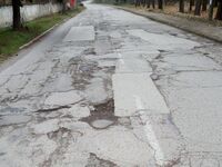
| |
| smoothness | bad | (robust_wheels) trekking bike, normal cars, commuter/standard motorcycles, Rickshaw and all below | Heavily damaged paved roads that badly need maintenance: many potholes, some of them quite deep. The average speed of cars is less than 50% of what it would be on a smooth road. However, it isn’t so rough that ground clearance becomes a problem. A ground clearance of a normal passenger car (>14 cm) is sufficient. Good unpaved roads without risk of damage to normal passenger cars are also included here. |  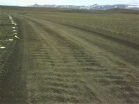
| |
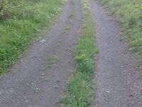
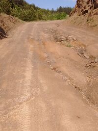
| smoothness | very_bad | (high_clearance) Car with high clearance, light-duty off road vehicles, adventure motorcycles (>180kg) | Unpaved roads with potholes and ruts, but still passable with an average SUV with a ground clearance of at least 18 cm.* | 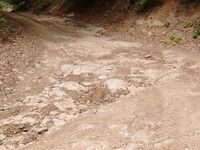
| |
| smoothness | horrible | (off_road_wheels) heavy-duty off road vehicles, dual-sport motorcycles (< 180kg) and all below | Unpaved tracks with ruts, rocks etc that need a ground clearance of at least 21 cm (Toyota Landcruiser, Landrover, Lada Niva, bukhanka, etc.). Skid plate protection is advisable. | 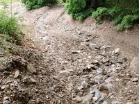
| |
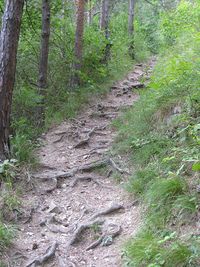
| smoothness | very_horrible | (specialized_off_road_wheels) tractor, ATV, tanks, Trial/Enduro motorcycles (<130kg), Mountain bike and all kind of off-highway vehicles (see also mtb:scale=*) | Tracks with deep ruts and other obstacles that need a ground clearance of at least 24 cm. | 
| |
| smoothness | impassable | No wheeled vehicle | Ways, often highway=path, that are not passable by any vehicles, not even mountain bikes or specialised off-road vehicles, but are recognisable in the landscape and may still be useful for hikers. Consider also lifecycle prefixes disused:*=* or abandoned:*=* if the way used to be a passable road but has deteriorated. | 
|
Please note: Photos are examples ONLY! The smoothness of a way should be assessed solely based on whether the way is usable by the vehicles mentioned above. A user of a certain road or path is only interested in whether the road can be driven or not. *Note that some unpaved tracks can be so steep that a car designed mostly for on-road use does not have the gear ratios and engine power needed to drive up a slope slow enough not to cause damage without the engine stalling. The track may still be smooth enough that such cars can drive down that slope without problem, so in such cases the track should be marked bad but the steep section tagged with incline=*.
This table is a wiki template with a default description in English. Editable here.
Also see the gallery of example photos broken down by surface=* type.
Other gallery: gallery 2
Variations in smoothness
Roads will vary in smoothness along their length. If a road is good in one part, but gets worse later, it’s worth splitting the road and tag each one with the appropriate smoothness tag. If for instance a dead-end road up a mountain valley needs a 4WD to reach the end, but a nice lake halfway up can be reached by normal car, then split the road at the lake and tag the first part as bad or better, and the second part as horrible. But don’t overdo it: if there’s a small “intermediate” section with a few repaired patches in an otherwise “good” road, most racing bike riders will not want to take a detour to avoid it but just be careful on the bad section, so such a road should be tagged good.
Roads can also vary in smoothness along their width. Such a road should be tagged with the quality of its best passable part. If for instance an unpaved road has deep ruts, but there’s enough space next to the ruts on one side so a normal car can drive on it with one rut in between the wheels, it should be tagged as smoothness=bad.
Usage
This tag isn't in use on the renderers at www.openstreetmap.org, but Hiking/mri and the Motorcycle map of Romania are using "surface" and "smoothness" to depict the real state of roads.
In developing countries, the HDM model is using some values of smoothness=* to help define road quality.
Certain navigation applications use smoothness information to propose an optimal route depending on the vehicle the user is using (e.g., road bike / city bike / mountain bike).
OsmAnd shows smoothness and surface, if enabled in the menu (Confgure map - Details). Here is the map key with the rendering for each smoothness and surface value.
http://www.roads-bg.eu shows the smoothness of the road network in Bulgaria using 4 colours that correspond to smoothness=excellent+smoothness=good (green), smoothness=intermediate (yellow), smoothness=bad (red) and smoothness=very_bad (dark red). Site visitors can suggest additions to the data.
Initial controversy
Discussions on the mailing lists around 2008 point out that part of the community did not like this key, based on a lack of verifiability — cf. [1], continued at [2]. As always on OSM you are free to use the keys you like in the way you like. See Talk:Accepted features/Smoothness for details on the controversial nature of this key. An initial effort to unify surface=* tagging was proposed, but this approach was abandoned.
See also
- surface=* - Describes the surface of a feature
- tracktype=* - Provides a classification of tracks
- sac_scale=* - classify hiking trails in mountainous areas with regard to the difficulties to be expected
- Approved smoothness proposal page - for further discussion of the tag
- Humanitarian OSM Tags/smoothness
- Projects, monitoring surface quality of roads via build-in accelerometer (smart-phone, tablet, etc.):
- https://smartroadsense.it
- WorldBank-Transport/RoadLab-Pro GitHub
- https://roadroid.com (commercial)
