Streets GL
| Streets GL | ||||||||||||||||||||||||||||||||||||
|---|---|---|---|---|---|---|---|---|---|---|---|---|---|---|---|---|---|---|---|---|---|---|---|---|---|---|---|---|---|---|---|---|---|---|---|---|
| License: | MIT License | |||||||||||||||||||||||||||||||||||
| Status: | Unmaintained | |||||||||||||||||||||||||||||||||||
| Language: | English
| |||||||||||||||||||||||||||||||||||
| Website: | https://streets.gl/ | |||||||||||||||||||||||||||||||||||
| Source code: | https://github.com/StrandedKitty/streets-gl | |||||||||||||||||||||||||||||||||||
|
Web-based 3D map that uses OpenStreetMap data. |
||||||||||||||||||||||||||||||||||||
| ||||||||||||||||||||||||||||||||||||
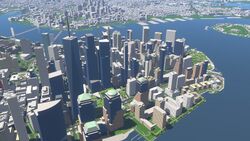
Streets GL is a web-based 3D map that uses OpenStreetMap data on top of a dynamic terrain. It was created as an open-source alternative to F4 Map and OSMBuildings.
It is made by StrandedKitty and was announced publicly on 2 May 2023 in the OpenStreetMap Community Forum[1] with the goals of "providing a way to explore the feature-rich OSM database in 3D, promoting open data, and offering a way for the mapping community to easily validate the map by visual means".
The project is written in Typescript. The rendering uses a custom low-level library that wraps the WebGL2 API, and for managing the rendering pipeline it uses a render graph (or frame graph) implementation. Geometry generation is done on the fly; supported map features include but are not limited to complex building shapes (according to the de-facto standard Simple 3D Buildings schema), roads and paths, trees, etc. Data is loaded from the Streets GL vector tile server.[2] It features complex post-processing effects such as dynamic time of day.
As of April 2025, the vector tiles use map data from 24 September 2023. Streets GL's code was last updated in September 2024.
Features
- Support for the most common OpenStreetMap features
- Configurable time of day
- Global map search powered by Nominatim
- Real-time air traffic
- Terrain with Levels Of Detail
- Deferred shading with Physically Based Rendering
- Rich post-processing: TAA, SSAO, depth of field, screen-space reflections & bloom
- Realistic atmosphere and aerial perspective rendering
External links
- Streets GL GitHub
- Alternative domain: https://streets-gl.pages.dev
