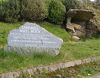
Tag:place_of_worship=mass_rock
| Description |
|---|
| A mass rock is a rock where (Catholic) mass was said during Penal times in Ireland and which was usually used as an altar. Some are still used annually. |
| Group: religion |
| Used on these elements |
| Requires |
| Implies |
| Useful combination |
|
| Status: approved |
| Tools for this tag |
|
A mass rock (Carraig an Aifrinn in Irish) is a naturally occurring rock which was used by Catholics as an altar during the time of Oliver Cromwell's occupation and the following centuries of Penal Laws in Ireland. They are often found in isolated locations with a good view, to be able to spot English soldiers approaching.
Some are still used annually or have been reinstated during the COVID19 pandemic, when indoor mass was not possible due to health restrictions.
There is also a tradition of mass stones in Scotland.[1].
As of May 2021, the Archaeological Survey of Ireland has mapped 8 mass rock sites at their present location[2].
Usage
Please only use the tag for outdoor altars that are natural=rock or natural=stone, not for outdoor (man made) altars which can be found in several graveyards or near the site of a place_of_worship=holy_well.
Examples
Sandhill Mass Rock and memorial near Dunfanaghy, Co. Donegal
Clashganny Mass Rock, Co. Carlow
Values
Draw a node or area for the stone or rock and add the following tags as required.
| Key=value | Explanation |
|---|---|
| amenity=place_of_worship | |
| place_of_worship=mass_rock | If the mass rock is no longer in use, please use was:place_of_worship=mass_rock instead. |
| natural=rock/ natural=stone | Please see respective definitions. |
| religion=christian | |
| denomination=* | denomination=roman_catholic
|
| name=* | Will usually be "townland name" + "Mass Rock" |
subject:wikidata=Q1907312 |
The wikidata link for "mass rock". If this mass rock has its own Wikipedia page or Wikidata number, use wikipedia=* and/ or wikidata=*. |
Optional extra tags
| Key=value | Explanation |
|---|---|
| description=* | Add any further information of interest. |
| tourism=attraction | If the mass rock can be considered an established tourist attraction, please indicate so. |
| historic=wayside_cross | If a cross has been erected nearby, please map it. |
| historic=memorial | If there is a memorial (plaque) commemorating the mass rock, please map it and include the inscription. |
| tourism=information + information=board | use this combination for information boards explaining the mass rock site. |
Tags for National Monuments Service/ Sites and Monuments Record (Ireland)
The National Monuments Service (NMS) in Ireland have given OpenStreetMap Ireland permission to use their records in OpenStreetMap, with a few restrictions. Please do not blindly copy the data into OSM, only if you have surveyed the location yourself and can confirm the presence of a mass rock. If the data is used, the following tags are required:
| Key=value | Explanation |
|---|---|
| source=National Monuments Service | |
| ref:IE:smr=* | This is the SMRS from NMS, for example DG016-033----. On the Historic Environment Viewer this is the header of an identified record.
|
| nms_class=* | This is the Class description. For mass rocks this is either: Mass-rock or Mass-rock (present location)
|
| nms_date=* | This is the date it was added to OpenStreetMap. In format: 2018-05-23
|
These features can be viewed on the Historic Environment Viewer.
Or an extract was taken on the 2021/05/23 and can be viewed on:
https://gisforthought.com/maps/mass_rocks/


