Tag:wetland=dambo
Jump to navigation
Jump to search
| Description |
|---|
| Seasonal wetland/flooded grassland. Term primarily used in Zambia and Zimbabwe. |
| Group: natural |
| Used on these elements |
| Requires |
| Status: in use |
| Tools for this tag |
|
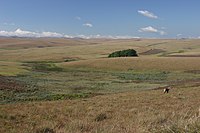
A ![]() dambo is a shallow wetland in particular in higher rainfall flat plateau areas in southern and eastern Africa. They are a mix of grasses, wet meadow and reedbed wetlands and may be substantially dry during the dry season. Dambos often have a clear drainage line either through or to one side of them and this drainage line is clear even during the dry season. They may also contain a pool of water at the lowest point called a pan, this water is intermittent and is a source of water for wildlife into the dry season.
dambo is a shallow wetland in particular in higher rainfall flat plateau areas in southern and eastern Africa. They are a mix of grasses, wet meadow and reedbed wetlands and may be substantially dry during the dry season. Dambos often have a clear drainage line either through or to one side of them and this drainage line is clear even during the dry season. They may also contain a pool of water at the lowest point called a pan, this water is intermittent and is a source of water for wildlife into the dry season.
How to map
Draw the outline ![]() of the area and tag it with natural=wetland + wetland=dambo.
of the area and tag it with natural=wetland + wetland=dambo.
