Template:Zh-hant:Map Features:cycleway
Jump to navigation
Jump to search
自行車道 (cycleway)
描述針對單車設計的基礎設施。另見: Cycle routes.
| 值 (value) | 幾何 (element) | 描述 (desc) | 照片 (photo) | |||
|---|---|---|---|---|---|---|
Dedicated bicycle lanes | ||||||
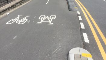
| lane | 在道路之中的自行車道。 | |||||
|
| ||||||
| shared_lane | Cyclists share a lane with motor vehicles, but there are markings indicating that they should share the lane with motorists. The road markings are usually there to highlight a cycle route or to remind drivers that you can cycle there. Also used for the on-road shared-lane marking called a "sharrow"[1]. | |||||
| share_busway | There is a bus lane that cyclists are permitted to use. | |||||
Bicycle tracks | ||||||
| track | 與道路分隔的自行車道,如果需要可加入oneway=yes。 | |||||
| separate | Should be used to indicate that a cycle track associated with a highway has been mapped as a separate OSM element (i.e., is tagged with highway=cycleway). Meaning is similar to the use of sidewalk=separate for footways, and can potentially be used when simplifying geometries for rendering. It also acts as a hint to avoid duplicating an existing cycleway by adding cycleway=track to a highway. Don't confuse with segregated=yes. | |||||
No bicycle infrastructure | ||||||
| no | Explicitly marks that a street has no bicycle infrastructure. This allows to explicitly note that the road was surveyed for bicycle infrastructure. | |||||
Other bicycle infrastructure | ||||||
| crossing | Used on separately mapped paths to indicate that it's a bicycle crossing. | |||||
| shoulder | Used to indicate that a road has no designated infrastructure for cyclists, but shoulders (a.k.a. breakdown lanes) are navigable and legal to cycle on. Especially on rural roads with high speed limits, the existence of a shoulder usable by cyclists can make the difference whether the road is usable at all (semi-)safely for cyclists. Not every shoulder=* is automatically usable for cyclists: Some shoulders are used for parking (parking=shoulder) instead, not all shoulders are paved (with asphalt, e.g. grass pavers). Additionally, shoulder=yes is typically only mapped for shoulders that are broad enough to accommodate a car. For cyclists however, a less wide shoulder is fine, too. | |||||
| link | A connector between OSM segments for cycle traffic, for example to connect a separately mapped cycle path to a junction on the opposite side. Serves primarily as a routing aid and does not necessarily have to be identifiable as built infrastructure. | |||||
| traffic_island | Used on the parts of refugee islands of a cycleway=crossing. | |||||
| asl | Indicates an advanced stop line or bike box at junctions. Use cycleway=asl on a |
|||||
| gap_jump | A gap jump segment of MTB downhill route. Generally would consist of two or three parts: a take-off ramp; a physically non-existent mid-air segment; and optionally a landing ramp (if not present, a regular bike track serves as a landing zone). The mid-air segment may cross other roads or features, in which case it should be tagged with layer=1 without a node at the intersection; surface=none has occasionally been added as well. Consider explicitly providing foot=no or access=no + bicycle=designated in order to prevent routing for any other activity. | |||||
Deprecated or discouraged tags | ||||||
| 與oneway=yes一起使用,予許自行車道雙向通行。
注意:這樣的街道在比利時,荷蘭,丹麥常見,而在英國不常見(但它們存在)。相對地,在一般的情況下整條街道為雙向是正常的,除了在街道最尾端的很小一段設為禁止禁入,這個地方設有一小段的分隔島來使自行車不要進入,這被稱為自行車接口(cycle plug)。在許多地方則是以非常短的單線道與相鄰的自行車道相併,且有道路併入而形成三角形,或有許有一張短的單線道且具有 cycleway=opposite_lane 或 cycleway=opposite_track。 | ||||||
| Cyclists share space with other traffic on this highway. | ||||||
This table is a wiki template with a default description in English. Editable here.
此表格由模版自動生成,協助改善中譯版本請按此。


