User:Ithaca eea/Great Limpopo Transfrontier Park (Africa)
Introduction
This page describes a plan to import land use data in The Great Limpopo Transfrontier Park (Africa) using the most updated data available from the Copernicus HotSpot Monitoring activity. The area of interest for this study is 65476 km² and involves three different parks: Kruger national park (South Africa), Limpopo national park (Mozambique) and Gonarezhou national park (Zimbabwe). Datasets are freely accessible through the Copernicus Hot Spot Land Cover Change Explorer. First, data will be downloaded and edited in GIS in order to ensure consistency between HSM classification and OSM tags system. During this phase, the land use attribute will be translated into the best matching OSM tag and uploaded to the database. As the data is partially planned to be uploaded several uploads into the OSM platform are foreseen with a certain frequency.
History
This work is part of the framework Service Contract EEA/IDM/15/026/LOT 2 for Services supporting the European Environment Agency’s (EEA) implementation of cross-cutting activities for coordination of the In Situ component of the Copernicus Programme Services. In particular, given the wide use of OSM data throughout Copernicus Services and given the fact that these Services produce value-added open data often on the basis of OSM content, the focus was on a set-up cooperation and integration agreement between Copernicus Services and OSM. In this case, the Copernicus Service considered is the High-Resolution Hot Spot Monitoring, which provides Land Cover and Land Cover Change products based on medium to high and very high-resolution images (from approximately 1 to 30m spatial resolution) with a change assessment frequency between 1 to 20 years, acquired for specific areas of interest with an initial emphasis on the African continent. It concentrates mainly on the domain of the sustainable management of natural resources, with an initial focus on Protected Areas (PA) or Key Landscapes for Conservation (KLC). The aim is to make the land use data produced by the Hot Spot Monitoring activity, available for a wider audience and for the Copernicus Service Providers as well, in a standardized format.
License
In this section will be added the Licence documents or references about the Copernicus Project and OSM.
Data and Accuracy
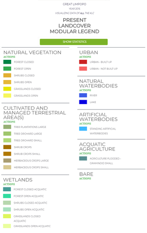
Great Limpopo land cover data has been produced in the framework of the Copernicus HotSpot Monitoring project, which mainly focuses on the sustainable management of natural resources, starting from Protected Areas and Key Landscapes for Conservation. It is freely accessible through the Copernicus HotSpot Land Cover Change Explorer. The product is based on the analysis of medium to high and very high-resolution satellite images (from approximately 1 to 30 m spatial resolution), with an acquisition date between 2013 and 2016. The Copernicus Hot Spot Monitoring classification scheme follows the Land Cover Classification System developed by United Nations FAO. The Great Limpopo product is available at two different levels of detail: a dichotomous classification and a modular one. The first one consists of eight categories, further detailed by the second one, for a total of twenty-four classes, as shown in the following legend:

Data Preparation
Due to the high detail level of the OSM tag system, the modular classification has been preferred. However, a process of data simplification has been carried out, in order to omit all the distinctions that have no matches in the OSM tag system or for which the tag system would require a more specific land cover description than the available source data. These include:
- references to the vegetation cover density and pattern, such as open/closed and small/large;
- distinction between “Urban - built up” and “Urban - not built up”
- distinction between “Aquatic agriculture” and “Herbaceous crop”
Each simplified HSM class has been associated with a specific OSM tag. The transformation process is summarized by the following table.
| Copernicus HotSpot Monitoring | OpenStreet Map tags |
|---|---|
| Tree plantation | landuse=forest |
| Tree orchard | landuse=orchard |
| Shrubs crop | landuse=farmland |
| Aquatic agriculture | landuse=farmland |
| Herbaceous crops | landuse=meadow |
| Forest | natural=wood |
| Shrubs | natural=scrub |
| Grasslands | natural=grassland |
| Aquatic forest | wetland=swamp |
| Aquatic shrubs | wetland=reedbed |
| Aquatic grasslands | wetland=wet_meadow |
| Urban | landuse=residential |
| Standing artificial water bodies | landuse=reservoir |
| River | water=river |
| Lake | water=lake |
| Bare land | natural=bare_rock |
Import Plan
The import will be done manually by at least one experienced user who will provide support and supervise the rest of the volunteers, all with dedicated usernames. The new users will have a work guide (in Spanish) to configure the environment and make the necessary adjustments.
- Software: Java OpenStreetMap Editor (JOSM) is a desktop editing application, written in Java. It runs on Windows, Mac OS and Linux. It is an open source editor for OpenStreetMap data and it allows the creation of new data and edit existing data for OSM.
- Workflow
- converting a portion of the DB downloaded from HSM and edited in GIS in a format readable in JOSM (50 km² fishnet*);
- open it in JOSM and edit data in .osm format;
- check and tick in the preferences panel the use of https://www.api.openstreetmap.org/api;
- download data from OSM of the same area (merge them in the same layer of the importing data);
- check tags (keys and values - see Tab.1), check if any duplication occurred and edit if needed;
- upload the result on OSM master server;
- follow up the upload and perform any clean-up requested by the community.
- The Test Database used: https://master.apis.dev.openstreetmap.org/api
- The OSM account used for the upload is "ithaca_eea"
- Any eventual change set will be tagged as: COPERNICUS_EEA
