WikiProject Belgium/Conventions/Slowroads
| Trage wegen (tagging proposal) | |
|---|---|
| Proposal status: | Draft (under way) |
| Proposed by: | talk-be |
| Tagging: | highway=* |
| Statistics: |
|
| Draft started: | 2016-01-28 |
Trage wegen / Voies lentes / Slow ways DRAFT
This page aims to aggregate the current conventions and uses of the Key:path, Key:track and document additional tagging, concerning local paths/tracks in Belgium.
This is still a draft page, created to help clarify open issues mentioned in this mailing list thread [1]
Definition
In recent years, the term "trage wegen / voies lentes" (literally "slow ways") is increasingly mobilized as a policy item in Belgium. Slow ways are commonly understood to be public roads intended for non-motorized use. As such, they encompass tracks of all widths, sightlines and surface, both rural and urban. People use slow paths for a multitude of activities; walking being the most straightforward (both for utility reasons and leisure). Other activities associated with slow paths include cycling, mountain biking, horse-riding, jogging en running, carriage driving, roller blading, nature study, play, etc.
Vicinal roads and the Atlas of Vicinal Roads / Atlas der buurtwegen / Atlas des chemins vicinaux
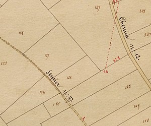
Quite of lot of these slow ways are "vicinal roads", an extensive network of pathways and country roads, tiny alleys and shortcuts in Belgium. Grown organically as the shortest routes between origins and destinations, slow ways have remained inscribed into Belgiums' vernacular landscapes for centuries. Many of today's existing slow ways reveal a century-old usage and are the remnants of these ancient desire lines. In order to formalize the road network of the newly formed state of Belgium, a vast cartographic operation was carried out in the period 1841-1845. Publicly used footways and cart tracks were mapped. This comprehensive mapping effort resulted into a nation-wide "Atlas of Vicinal Roads" / "Atlas der buurtwegen" / "Atlas des chemins vicinaux". Each local community in Belgium (except from the German speaking municipalities, which were no Belgian territory at the time of the making of the Atlas) possesses a physical extract of the Atlas, covering the total territory under their authority and jurisdiction. Still today, these somewhat worn out map sheets can be freely consulted in every town or city hall in Belgium. SInce a few years, all the Atlasses in Flanders have been scanned and are available on the internet. The use of the Atlas of Vicinal Roads as a mapping source is filed under "open data".
Legal reference, public right of way
The Atlas of Vicinal Roads continues to stand as a key legal reference document for the protection or rehabilitation of slow ways today in Belgium. A public right of way is imposed for paths and roads within the Atlas. Many vicinal roads are also the public property of the municipalities. Most of these vicinal roads are nowadays the actual streets.
Gradual decline
However, this legal foundation has not prevented the gradual decline of the slow ways network throughout the twentieth century. The boosting of automobile traffic from the mid-twentieth century on has formed a lasting pressure on slow ways development. Car culture in general decreased the use of footpaths and cycleways. Many ancient pathways were surfaced to cater for motor vehicles and the remaining tracks for non-motorized use became split up or obstructed by motorways, as well as by other modern, linear infrastructure elements (canals, motorways, railways, etc.). Formerly functional loops or connections got cut off, accelerating their dereliction. The traditional net of pathways in Belgium further thinned out due to the intensifying and scaling up of agricultural land-use and to a sprawlling urbanization, combined with a permissive planning system. For decades, local authorities neglecting the maintenance of their public slow ways infrastructure were all but an exception. Many slow paths got out of use, privatized, fenced off, ploughed in, blocked, neglected, abandoned ... or simply forgotten. As a result, the web of slow paths existing today only represents a tiny share of the potential network.
What to map / what not to map
OpenStreetMap generally only maps things that are verifiable on the ground by non-specialists. There are some exceptions, for example administrative boundaries. However, these need a strong motivation. See Map Features and Good practice for more examples.
Trails can be something of an exception too. For example, a hiking route might contain a section where you cross a meadow, without there being any visible marks on the ground. But normally, something like the simple fact that it is possible to cross a forest does not get added to OpenStreetMap.
When mapping slow roads, the Atlas of Vicinal Roads is sometimes used as a source. Keep in mind that some of these trails only exist from a juridical point of view. Most Openstreetmappers would say that these do not belong in OpenStreetMap. However, if a trail from the Atlas of Vicinal Roads is clearly visible in reality, it does have a place on the map. It might be useful to add extra tags indicating how difficult it is to use the trail. See Slow roads/Useful tags for more info.
In practice however, this means you actually need to get out there and verify the situation on the ground - you can't just map things because they are in the Atlas of Vicinal Roads. Openstreetmap does not intend to collect as much information as possible. It strives to get as much verified information as possible. Sometimes external information sources can provide that, but sometimes they don't.
Since the start of the corona crisis, the Belgian OpenStreetMap chapter started recieving many complaints about paths mapped in OpenStreetMap that according to the complainy are illegal to use. We also often spot new contributors simply deleting these paths. The core policy of OpenStreetMap is that what is verifiable on the ground always comes first. If a path is visible on terrain, it can be mapped. The fact that it is not allowed to use it, is an attribute of a path - not a reason for deletion. Unfortunately, since we do not map for the render, that means that some maps will show these paths without making it very clear to the user that they should not use them. The Belgian chapter actively engages data users to improve their practices. If you spot data use issues, please report them to community@osm.be or add them to our Issue on GitHub. Our default Dutch and French letters to deleters is at this wiki page, which also explains some benefits to keeping things you dislike on the map.
Deciding what to map
Since it's hard to understand what to use depending on all the information you have, we will describe some typical consideration and observations you make in order to determine the correct tags and/or if it even belongs in OSM.
Simple
- visible and accessible year-round: in OSM
- invisible and totally inaccessible (e.g. going through building): not in OSM
Hard
It gets a bit more tricky in the border cases
- visible and inaccessible (e.g. due to fence): in OSM, with access=no or whatever is appropriate and mapping the barriers.
- sometimes visible and year-round accessible: in OSM, with detailed trail_visibility=no for those stretches that are not visible.
- visible and sometimes accessible (due to fences): in OSM and lots of fun with the access tags
- visible and sometimes accessible (due to vegetation): in OSM, with detailed trail_visibility=bad for those stretches that are likely to be inaccessible due to vegetation. Is there by now a seasonal tag that can be used?
- invisible and year-round accessible: this is probably the most controversial one. Consensus is that there should be some sort of local verifiability before mapping them. For example a signpost or a waymarked path using the section.
- year-round invisible and year-round inaccessible (e.g. due to fence): not in OSM (motivation: "we map what's there, this isn't a thing"). Of course, if you can get the reality to change, you can map this new reality.
If a path has been mapped before, and you feel it does not exist anymore, it is recommended to retag it using the lifecycle prefixes. This makes it disappear for almost any data user, but keeps the history of the object easily visible for other mappers.
Physical appearance determines tagging
Attention, we try to establish an uniform way for tagging slow ways in Belgium. Therefore, a topographic approach is handled: a path is a small way, a track is generally wider and often combined with service or agricultural traffic. We pledge to pay attention: people make a difference between track/path, but often it's the same thing, or the other way around. See highway=track, but highway=path might be useful too.
Animal trails
Some trails are made by animals, by making the same trip again and again. We usually do not map them, unless they can be used by humans. In that case, just tag it as a normal highway=*. if you're really sure it is an animal trail, add animal_trail=yes.
In most cases, these paths are not suitable for humans. They might change a lot, they often have dead ends, you're not allowed to use them. For example, think of vague trails within nature reserves, made by resident cattle. Often these should not be used by humans. To avoid them getting mapped as a "real" paths, just map them as not:highway=path + animal_trail=yes . This is of course only possible when you have extensive terrain knowledge.
General information
There are different customs, rules and signs in use in Belgium. Tagging them has been varying. We have to devise a standard way in tagging our unique needs. Keep in mind the implicit tags these different Key:highway types have. User Eimai wrote a nice overview of tagging conventions in Belgium [2], including relevant traffic signs.
Standard tagging
- highway=path This is the default tag. However, there are other options too. This section intends to help you choose the main tag of the way you're editing. This is the most important tag you'll add. Without this, your way will be useless to data users.
In the case of footpaths and cycleways that are not independent of a normal traffic road, they might be mapped as a tag of this road. This page is focused towards independent slow roads.
| Type | Comment |
|---|---|
| track |
Generally unpaved roads with traces of motor traffic or accessible to motor traffic. Usually associated with agriculture or forestry. Unpaved roads can be something else than a track, if they are important enough. For example if they are the main access road to some houses. Some people would argue that paved roads can be tracks, for example if they are quite small and only accesible to agricultural vehicles. |
| path |
All paths which are not passable by agriculture or similar vehicles|| Including streets 'designed' for vehicles but where access is restricted to pedestrians |
| cycleway |
Paths designated for cyclists. In Belgium, that means there's a blue sign with a bicycle. Other users, like pedestrians, might be allowed too. More details about cycleways here [3] |
| footway |
Paths 'designed' for pedestrians where vehicles have no access. |
| pedestrian | Roads designated for pedestrians. Usually traffic free zones in city centers, like shopping streets. Bicycles and motor vehicles might be allowed too, often conditionally. |
Names
- name=name of slow way This is the official name. Preferably, this name appears on a name plaque at the start/end of the road. But a lot of public footpaths that are listed in the Atlas of Vicinal Roads have an official name. The name can be found in that case in the annexed tables to the Atlas of Vicinal Roads.
If no name is found, do not just include descriptions like "Path to the Church" here.
Sometimes the only available name is the number given in the Atlas of Vicinal Roads. There is some discussion as to whether and when to include these names. If you find a signplate "Voetweg 10", you can argue that it is the official name.
Often, the name in the Atlas of Vicinal Roads has been replaced by a new official name. Most of the time, it is only about spelling, but sometimes there is a new name. The old name in the atlas can still be put under this tag.
Reference
- vicinal_ref="Vicinal road 123" This is reference found on the plans in Atlas of municipal roads, or also on street signs. This tag can be combined with the nametag to be rendered on Belgian tile layers. Eg. 'Voetweg 44', 'Sentier 66 bis', 'Chemin 87', 'Pad 42', 'Baan 105' are all possible situations.
- official_vicinal_ref=XXX_123_1 This is the official ref number. XXX stands for the "Atlas municipality", 123 for the number of the road in the Atlas of Vicinal Roads and the last number is by default 1. If the road in the atlas is, eg. Sentier 123 in Wolvertem (Meise), the ref nr. will be = WOL_123_1. If it is Sentier 123 bis, use WOL_123_2, and so on. Not every slow way is a vicinal road. Not every vicinal road is slow, so this tag can also apply on other Key:highway in Belgium.
- vicinal_type=path We use path when the way on the atlas appears as a sentier, as a voetweg, voetpad or pad. (The terms differ from atlas to atlas) Attention: what was once a smal sentier (footpath) of 1 m width can now be a field track of more than 4 meters.
- vicinal_type=road We use road when the way on the atlas appears as a chemin, as a weg, rijweg or baan. (The terms differ from atlas to atlas) Attention: what was once a field road of more than 6 meters can now be a tiny footpath of merely 1 m width.
Do not use ref=1234 for this information. This is used for roads, like ref=N60 or ref=E40. The problem is that references to the Atlas are not in the same government systems as the main roads. That might result in a query for the E40 resulting in both a freeway and a footpath.
Legal designation
Slow roads might have a specific legal designation (a 'statute'). We use the designation tag for it.
In Brussels there are 3 possible designation values.
- designation=vicinal_road The road appears in the Atlas of Vicinal Roads or in its modifiyng documents.
- designation=communal_road_ss The road is property of the municipality AND it is destinied for public use AND it does not appear in the Atlas of Vicinal Roads.
- designation=right_of_way_ss The road is a public right of way, but does not show up in the Atlas of Vicinal Roads. One should clarify this value by citing a source through a source:designation=http://... tag. A source for this category is most likely a link to a ruling conceding the public right of way.
In Wallonia and Flanders, you only have one value:
- designation=communal_road The road appears classifies under the Decree of Communal Roads, that integrates all former legal categories. However, since the Atlas of Vicinal Roads has not (yet) been abolished, the reference-tags might still stand for Wallonia and Flanders as well. Replacing the atlasses will be a task for the Wallonian municipalities, it is not expected yet. In Flanders, the atlasses will not be replaced, individual roads might be modified or abandoned.
Visibility
Not all trails are clearly visible. A path might be overgrown or plowed away. But later in the season, it might still re-appear.
One could use trail_visibility=bad or even trail_visibility=no for it.
Physical accessibility
Some tags are in use to indicate if a path is accessible in a wheelchair. These are used most of all by the Wheelmap project.
Examples
All these can be improved probably. < please suggest edits for those track, not all tags make sense >
- Example simple path
 Example simple path
 - Example path
 Example path path that has name=Jaagpad, 'Jaagpad' is a very common name in OSM now, it is better to put this definition in a description=*. See Example of a more detailed track
 Example of a more detailed track
More examples via overpass
Using a broad overpass query, we can check for more slow ways, tagged highway=path, highway=track or highway=footway. It's possible you will encounter ways that need corrections.
Different kinds of tracks/paths
The first big question as always, do I have to use highway=path, highway=track or even highway=footway ?
When to use path
For narrow roads (in general, narrower than 1,75 m, no car can pass). When there is evidence that it is a public footpath (Atlas of Vicinal Roads of signposted), preferably highway=path should be used, together with the proper designation=vicinal_road
When to use footway
For narrow roads (in general, narrower than 1,75 m, no car can pass) that are clearly built for pedestrian use.
When to use track
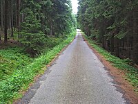
For wider roads (in general, wider than 1,75 m, so a car can pass).
Tracktype
See below for tag values for 'tracktype':
| Key | Value | Element | Comment | Rendering | Photo |
|---|---|---|---|---|---|
| tracktype | grade1 | Solid[1]. Usually a paved surface (called also |
|||
| tracktype | grade2 | Mostly solid. Usually an unpaved track with surface of gravel mixed with a varying amount of sand, silt, and clay. See Gravel road on Wikipedia. May be applicable to heavily degraded and crumbled roads which were paved in past. Often also tagged with surface=gravel;compacted;fine_gravel etc. |
|||
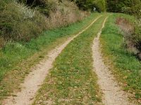
| tracktype | grade3 | Even mixture of hard and soft materials. An unpaved track. |
|||
| tracktype | grade4 | Mostly soft. An unpaved track prominently with soil/sand/grass, but with some hard or compacted materials mixed in. |
|||
| tracktype | grade5 | Soft. An unimproved track lacking hard materials, uncompacted, with surface of soil/sand/grass. |
|||
| tracktype | <no value> | If no tracktype tag is present, the track is rendered with a dot-dash line style (as shown right). |
This table is a wiki template with a default description in English. Editable here.
Barriers
In a lot of changesets, you will discover that the mapper did more than just map the slow road. When surveying an area, you have more information at your disposal which you could introduce in OSM. Things like barrier=* could easily be encountered on a hiking trip. Make sure to tag them in a consistent way.
Linear barriers
This table is a wiki template with a default description in English. Editable here.
Access control on highways
This table is a wiki template with a default description in English. Editable here.
Fences
For barrier=fence you can go into detail using fence types:
Fence type
Describes the properties of a fence.
| Value | Comment | Photo |
|---|---|---|
| barbed_wire | A |

|
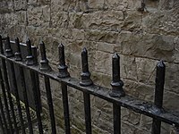
| bars | A fence made of (usually metal) bars. Sometimes also called “pool fencing” and used around swimming-pools. | |
| You are encouraged to no longer use this tag as the former definition was confusing. Instead, use barrier=chain or barrier=fence + fence_type=chain_link. | ||
| chain_link | A |

|
| concrete | A fence made of concrete blocks or concrete elements with special geometry. It can be opaque or hollow.
Consider using material=concrete instead. |
|
| corrugated_metal | Light steel sheets with linear corrugated pattern (wavy, trapezoidal, etc.). Also known in Australia as Colorbond fencing. | 
|
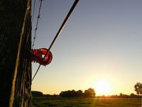
| electric | An |
|
| glass | A fence made of hardened glass panels, usually supported at intervals by metal posts. Often used for swimming pool or verandah fencing, when you want to be able to easily see through the fence. | 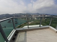
|
| knee_rail | A fence made of a single rail (usually either diamond-shaped or round) supported at approximately knee level by vertical posts. Common around car parks, etc. Often made of wood or metal. | 
|
| krest | Typical metallic pedestrian fence PO-1 "Krest". Used in cities of Russia for fencing around crossings. Widely used in France on sidewalks and known as "Croix de Saint-André" (St. Andrew's Cross or X-shaped cross) | 
|
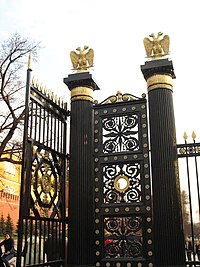
| metal | A fence mainly made of metal. This is a broad (rather unspecific) value.
Consider using a more specific type of metal fence: e.g. bars, krest, railing, wire. Or use material=metal instead. |
|
| net | A net fence is a flexible type of woven fence usually made from plastics and typically used to prevent balls or equipment from leaving designated areas (e.g. sports fields), protecting spectators, players and surrounding property. | 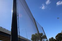
|
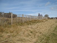
| paling | A variety of fences, usually consisting of either vertical posts tied together with wire, or vertical boards nailed to horizontal braces. | |
| panel | A fence made of prefabricated panels that are inserted into grooves in concrete (or wooden) fence posts. | |
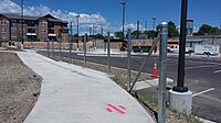
| pole | A fence mainly made of simple poles. | 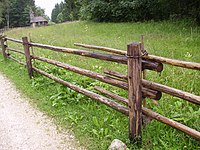
|
| post_and_rail | A variety of fences usually made of horizontal rails on top of vertical, or sometimes slanted, posts. | |
| railing | A railing for example at the edge of a bridge to prevent persons or vehicles from falling down. Often made of metal or wood. | 
|
| roundpole | A |

|
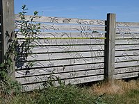
| slatted | A fence made of wooden or concrete upright posts, with usually three horizontal wooden rails, to which vertical wooden boards are fastened. | 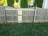
|
| split_rail | A |

|
| temporary | A |
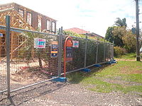
|
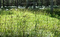
| wire | A fence mainly made of wire, in a variety of styles; e.g. welded vertical wires, horizontal wires strung through / between posts, wire mesh. |  |
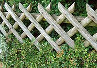
| wood | A fence mainly made of wood. This is a broad (rather unspecific) value.
Consider using a more specific type of wooden fence: e.g paling, post_and_rail, roundpole, slatted, split_rail. Or use material=wood instead. |
|
| User defined | All commonly used values on Taginfo. |
This table is a wiki template with a default description in English. Editable here.
External data
For a quick overview of historical maps with OSM roads overlayed, see this historical map.
Trage wegen Inventory
There is a WFS and WMS server we can use:
- http://geo.vlaamsbrabant.be:8888/TrageWegen/MapServer/WFSServer?
- http://geo.vlaamsbrabant.be:8888/TrageWegen/MapServer/WMSServer?
There's also a viewer for those who don't like to work with WMS/WFS.
Trage Wegen combined these data with modifications and historical maps > https://www.tragewegen.be/trage-wegen-kaart
There is no downloadable file, but adding the WFS in QGIS will trigger a full download, which you can save as a local file.
Chemins.be viewer
Inventory of slow roads in Wallonia, probably the best actual source > http://www.chemins.be/
Atlas der Buurtwegen / Atlas des chemins vicinaux /Atlas of Vicinal Roads
Flanders
- Province of West-Vlaanderen: http://www.giswest.be/trage-wegen
- Province of Oost-Vlaanderen: http://www.gisoost.be/ATLASBWNEW/ or direct access to the database http://www.gisoost.be/home/atlasbw.php
- Province of Vlaams-Brabant: http://geo.vlaamsbrabant.be/mobiliteit/ (select 'Atlas der Buurtwegen')
- Province of Antwerpen: http://geoloket.provincieantwerpen.be/geoloketten/?viewer=extern&LayerTheme=1
- Province of Limburg: https://geo.limburg.be/abw
Wallonia
There is now one digital atlas for the whole of Wallonia: http://geoapps.wallonie.be/atlas1841
- Province du Brabant Wallon : Avenue Einstein 2 – Bâtiment Archimède à 1300 Wavre – Tél : 010/23.62.51. Ouvert au public sur rendez-vous.
- Province du Hainaut : https://sigatlas.hainaut.be/Atlas_Voirie/, provincial archive: Site du Clair-Logis, Rue St Antoine, 1 à 7021 Havré – Tél : 065/87.97.02. Ouvert au public tous les jours ouvrables de 8h00 à 12h00 et de 13h00 à 16h00.
- Province de Liège : Rue Darchis, 33 à 4000 Liège – Tél : 04/230.48.00. Ouvert au public tous les jours ouvrables de 8h00 à 12h00 et de 14h00 à 16h00. Site : http://www.prov-liege.be/stp
- Province du Luxembourg : Square Albert 1er,1 à 6700 Arlon – Tél : 063/21.22.59. Ouvert au public tous les jours ouvrables de 8h00 à 12h30 et de 14h00 à 16h30.
- Province de Namur : Chaussée de Charleroi, 85 à 5000 Namur – Tél : 081/77.54.53. Ouvert au public tous les jours ouvrables de 8h30 à 11h30.
- You can download the scans from these atlasses via http://www.itineraireswallonie.be/atlas/namur.php
Brussels Capital Region
Scans are available on demand via the documentation centre of the AATL/BROH-administration of the Region. Vooruitgangstraat 80/1,1035 Brussel Tél: 02/204.24.96 Fax : 02/204.15.22
Wegverbindingen GRB
The scope of this dataset is much more limited. However, sometimes a slow road does get mapped in this data. This is open data with a compatible license.
NGI road network
This is the map of all roads and small roads in Belgium. The Flemish AGIV is using and improving the data, and will release as open data. The data contains a lot of slow roads, much more than their GRB. The quality is good enough to warrant a survey when a slow road is missing in Openstreetmap, however preliminary testing suggested that it is not good enough to just copy features.
Other Conventions pages
- WikiProject Belgium/Conventions
- WikiProject Belgium/Conventions/Bus and tram lines
- WikiProject Belgium/Conventions/Bus stops
- WikiProject Belgium/Conventions/Cycle Routes
- WikiProject Belgium/Conventions/Cycleways
- WikiProject Belgium/Conventions/EU institutions and bodies
- WikiProject Belgium/Conventions/Highways
- WikiProject Belgium/Conventions/Places
- WikiProject Belgium/Conventions/Railways
- WikiProject Belgium/Conventions/Schools
- WikiProject Belgium/Conventions/Signs in nature reserves
- WikiProject Belgium/Conventions/Slowroads
- WikiProject Belgium/Conventions/Special needs schools
- WikiProject Belgium/Conventions/Street names
- WikiProject Belgium/Conventions/Walking Routes


