WikiProject Belgium/Conventions/Cycle Routes
| WikiProject Belgium +/- | ||
| Conventions | ||
| Subprojects | ||
Mapping of walking and/or biking routes must be restricted to routes signposted by an official tourism agency that is assigning the node numbers, if any, and writing them to the signs.
It's best to use relations for tagging cycle networks. Both the online editor Potlatch and JOSM can handle relations. Just press the button "Add relation" and enter the keys and values.
See WikiProject_Belgium/Cycle_Routes for a detailed listing of networks and routes in Belgium.
Long distance routes (LF and RV)
These routes don't exist anymore since beginning 2021 and are replaced by Icoonroutes. Any sign on the ground should have been removed. The old wiki table can still be found here in this archive page
The RV routes (Rando Vélo [1]) are most probably not maintained anymore. A list remains available on WikiProject_Belgium/Cycle_Routes.
The marking is based on yellow/blue marks on trees, poles, similar to the GR network.
Fietssnelwegen ("cycle_highways", Flanders)
Cycle highways are intended to be a high speed functional cycling network. They are tagged with an additional cycle_highway=yes. See cycle_highway for general information and this page for conventions for the cycle highways in Flanders.
RAVeL network (Wallonia)
The RAVeL (Réseau Autonome de Voies Lentes) network stretches across Wallonia [2]. It is built almost exclusively on preexisting infrastructure and completed with interconnection links on low traffic roads and bicycle friendly tracks to form a comprehensive network.
The routes with a name beginning with an "L" are former railway lines and their number is the old number of that railway line. The routes beginning with W are either built along waterways or formed with a combination of other routes and interconnection links.
| Tags | Description |
|---|---|
|
type=route |
The RAVeL W3 route, which runs from Tubize to Chimay. |
Itinéraires Cyclables Régionaux - Gewestelijke Fietsroute (Brussels)
The ICR-GFR network spans across the Brussels Capital Region. Most of the routes are tracks or lanes along the regular streets of the city. All routes are completed tagged, marked and indicated.
Routes are numbered from 1 to 12 going clockwise away from the center, and from A to C when circling around the city center. Some radial routes split and are thus numbered with extra capital letters, for example 1 become 1A and 1B. Also 4 routes based on geographical marker (CK, SZ, MM, PP).
As these route sometimes use oneways for cars, make sure you add the proper cycleway attributes.
| Tags | Description |
|---|---|
|
type=route |
The ICR-GFR 6, which runs from the Law Court to Linkebeek and Rhode-Saint-Genèse / Sint-Genesius-Rode. |
European routes
See the wiki page dedicated on EuroVelo routes.
Cycle Node Networks
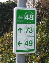
Cycle node networks [3] (nl: fietsknooppuntennetwerk, fr: réseau cyclotouristique) differ from other routes since in this case the places where routes come together are numbered instead of the routes themselves.
Therefore, the nodes will get the reference numbers like:
| Tags | Description |
|---|---|
|
rcn_ref=09 |
A "09" node in the network. |
The routes between the nodes are created with relations like:
| Tags | Description |
|---|---|
|
type=route |
A route between two nodes. The "note" and "operator" keys are optional. |
Important: each track between two nodes requires a new relation.
When the routes follow different roads in both directions between two nodes, use the proper "forward" and "backward" roles for each relation member. See here for details.
TODO: How to tag shortcuts, alternative roads, routes leading to/from the network (from a city or town center for example)?
Also, have a look at the expanded tagging in Cycle Node Network Tagging, which is currently already being used in parts of Belgium and The Netherlands.
Themed cycle routes
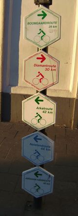
These are smaller loops, marked with six-sided signs like in the picture on the right.
These routes are usually marked in one direction only, and form a closed loop. Some routes have shortcuts, sometimes there are special connections between different routes, and some have a special start route which brings them from for example the center of a city to the route itself.
Examples are Architectuurroute, Brialmontroute, Aardbeienroute, Heideroute, Keizer Karelroute... Characteristic of these routes is that they have themes: they'll guide you for example along castles, through heaths, along places which were important for a famous person etc.
These routes have no reference numbers, just these names. This may be a problem for rendering the map.
Tagging example:
| Tags | Description |
|---|---|
|
The Brialmontroute, a themed route near Antwerp. |
When the routes are one direction only, use the proper "forward" and "backward" roles for each relation member. See here for details.
There are similar routes made for walking.
Shortcuts and alternate routes
Many routes have shortcuts and/or alternate routes. Each of these gets its own relation, with an adapted name=* and state=alternate tag.
Tagging examples:
| Tags | Description |
|---|---|
|
type=route |
Shortcut for the Architectuurroute. |
| Tags | Description |
|---|---|
|
type=route |
Alternate way for a specific part in the Architectuurroute. |
Mountain bike routes
Example of a (local) mountainbike route:
| Tags | Description |
|---|---|
| type=route |
|
| route=mtb |
|
| name=Duinengordel Groen |
include colour in name |
| ref=DG |
combination of the first letters of name (or city) and colour |
| colour=green |
|
| symbol=triangle |
|
| osmc:symbol=green:white:green_triangle |
|
| mtb:type=crosscountry |
applies to almost all mtb routes in Belgium |
| signed_direction=yes |
if applicable |
Example of an 'inrijtraject':
| Tags | Description |
|---|---|
| type=route |
|
| route=mtb |
|
| name=Inrijtraject Sportzone Gruitrode |
name as specified on the maps provided by Sport Vlaanderen (if provided) |
| ref=I |
|
| colour=yellow |
|
| symbol=triangle |
|
| osmc:symbol=yellow:white:yellow_triangle |
|
| mtb:type=crosscountry |
applies to almost all mtb routes in Belgium |
Example of an 'verbindingstraject':
| Tags | Description |
|---|---|
| type=route |
|
| route=mtb |
|
| name=Verbindingstraject Neerpelt Zwart - Bocholt Groen |
|
| ref=V |
|
| colour=yellow |
|
| symbol=triangle |
|
| osmc:symbol=yellow:white:yellow_triangle |
|
| mtb:type=crosscountry |
applies to almost all mtb routes in Belgium |
More info can be found here.


