Philippines/High-resolution imagery
Imagery coverage map
OSMPH Imagery coverage map. This map gives an overview of the coverage of all available imagery in the Philippines that can be used by OpenStreetMap contributors for tracing. The map currently includes Bing, Spot5, and the JAXA imagery in Cagayan Valley. Please check out the individual sections for each type of imagery for more details.
Bing aerial imagery
Bing provides the largest source of satellite imagery that can be used for tracing.
In early February 2012, Bing maps has added and updated quite a lot of satellite imagery in the Philippines. You can check out the actual coverage via the special imagery coverage map.
The display of Bing imagery is already built-in for tracing in Potlatch 2, JOSM, and Merkaartor.
(Note: The large scope of the February 2012 update makes the previous way of documenting the coverage—by listing each set of contiguous imagery in tables—infeasible. As such, the documentation is now done exclusively via the imagery coverage map.)
Alignment issue
Take note that Bing imagery in not always positioned correctly and that there may be offsets of up to 10 meters or so. See the image to the side for an example. Notice that the residential streets do not line up with each other.
Before tracing from Bing, try to position or align the imagery first if possible. Potlatch 2, JOSM, and Merkaartor all have features for moving the background imagery. The standard way of correcting the alignment is to use available GPS traces in the area. You can average multiple GPS traces to get a good enough positional accuracy.
If there are no available GPS traces, then it's acceptable to trace the Bing imagery directly. Someone can realign the map later on when GPS traces would become available.
Here's an example of aligning Bing Maps imagery:
Tips: When trying to align the image, look over a larger area where GPS traces are available and do a best fit over that area. In addition, the best spots to inspect for alignments are intersections and curves in the roads.
Other imagery sources
QuickBird & Spot5 (donated)
| General area | Places covered | Estimated date of image | Remarks |
|---|---|---|---|

|
Binalonan, Calasiao, Dagupan City, Laoac, Manaoag, Mangaldan, Papandan, Pozzorubio, San Fabian, San Jacinto, Santa Barbara, Sison, Urdaneta City (Pangasinan) | The date of imagery is April 2006, August and October 2009. | High resolution QuickBird satellite imagery was kindly donated by DigitalGlobe with coverage of Pangasinan, one of the affected areas. Add the tag source=quickbird when using the imagery. |
 Portions of Bulacan, Pampanga and Nueva Ecija Portions of Bulacan, Pampanga and Nueva Ecija
|
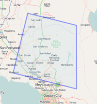
Bocaue, Bustos, Bulacan, Calumpit, Dona Remedios Trinidad, Guginto, Hagonoy, Malolos, Marialo, Norzagaray, Pandi, Paombong, Plaridel, Pulialn, San Ildefonso, San Jose del Monte, San Miguel, San Rafael, Santa Maria (Bulacan); Kalookan (Metro Manila); Cabiao, Gapan, General Tinio, Jaen, San Antonio, San Isidro, San Leonardo (Nueva Ecija); Apalit, Arayat, Candaba, Macabebe, Mexico, minalin, San Luis, San Simon, Santa Ana, Santo Tomas (Pampanga); Rodriguez (Rizal) | 2008-03-12 | SPOT5 imagery donated by SPOT5 Asia and Certeza Infosys. The imagery has a resolution of ~10 meter. Add the tag source=spot5. |
User:gravitystorm has made this available as tiles at the following URL:
https://gravitystorm.dev.openstreetmap.org/imagery/philippines/
Using in Potlatch
You can switch to it mid-editing by going to the settings and pasting in the custom tile URL:
https://gravitystorm.dev.openstreetmap.org/imagery/philippines/!/!/!.png
Using in JOSM
1. Get the "Slippy Map" plugin. Preference >> Plugins. Restart JOSM.
2. Add this URL in the Slippy Map Plugin configuration:
</tt>https://dev.openstreetmap.org/~gravitystorm/imagery/philippines/
You can set the maximum level to 19. Restart JOSM
3. The slippy map layer should be activated when you download some data within the boundingbox above.
Using in Merkaartor
1. Find and edit the TmsServersList.xml file. (in the ~\.merkaartor folder for linux systems)
2. insert this just before the </TmsServers> line :
<TmsServer minzoom="14" maxzoom="19" path="/~gravitystorm/imagery/philippines/%1/%2/%3.png" address="dev.openstreetmap.org" name="Pangasinan" tilesize="256" />
3. The end of the file should now look like this:
<TmsServer minzoom="0" maxzoom="17" path="/tiles/1.0.0/openaerialmap-900913/%1/%2/%3.png" address="tile.openaerialmap.org" name="OpenAerialMap" tilesize="256" />
<TmsServer minzoom="14" maxzoom="19" path="/~gravitystorm/imagery/philippines/%1/%2/%3.png" address="dev.openstreetmap.org" name="Pangasinan" tilesize="256" />
</TmsServers>
</MerkaartorList>
4. save and start Merkaartor
5. Select the menu "Layers", then "add new image layer"
6. Select the menu "Layers", then "Map-none", "TMS-Adapter", and last "Pangasinan".
More info here
Disaster/Humanitarian imagery
Various imagery rectified to support disaster response.
| General area | Places covered | Estimated date of image | Remarks |
|---|---|---|---|
| Northern Luzon, way | Palanan, Isabela | 2008-08-28 | Imagery to support floodong in Cagayan |
| Northern Mindanao - JAXA ALOS AV2 March-April 2010 | Misamis Oriental, Lanao del Sure, Bukidnon | March - April 2010 | Imagery to support Typhoon Sendong disaster response |
| Northern Mindanao - Pan-sharpened JAXA ALOS AV2 | Misamis Oriental, Lanao del Sure, Bukidnon | 2010-05-06 | Imagery to support Typhon Sendong disaster response |
| THEOS Pansharpened in Northern Mindanao | Cagayan De Oro and Bukidnon | 2011-12-21 | Imagery to support Typhoon Sendong disaster response |
OrbView-3
LANDSAT
Covers the whole country. Resolution is around 30 meters however the imagery is off by as much as 50-100 meters in some area. The data is between 1999 - 2000. Useful for tracing coastlines, large rivers and homogeneous landuse/landcover.
Imagery Request
Add here any area you want to have high resolution imagery. No promises, but we will try to find a way.
- Ormoc, Leyte - http://osm.org/go/4tXGsf4F-
- Boracay, Aklan - http://osm.org/go/4ymKI04
Donating high resolution imagery
If anyone is willing to donate high resolution imagery for the Philippines, please contact User:maning or send a message in the mailinglist.
| |||||||||||||||||||||||||||||||||||||||||


