ES:Equitación
Si comprendes el artículo original en inglés, por favor, ayuda a completar esta traducción al español. Lee las instrucciones sobre cómo traducir este wiki.
Parece que nadie está trabajando en la traducción en este momento. Anímate y colabora en la tarea de traducción.

|
| Descripción |
| About tagging of ways, points, areas and relations related to horse riding. |
| Etiquetas |
This article is dedicated to features related to horse riding.
Features
The following table contains a list of features together with their correct tagging and an exemplary photo. Keys written in italic are proposed and not yet approved. For a detailed description of each feature see the associated article.
| Feature | Tagging | Element | Description | Photo |
|---|---|---|---|---|
| Access restriction | horse=* | If horse riders are allowed (horse=yes) or forbidden (horse=no) in a specific area. | 
| |
| Bridleway | highway=bridleway | A way intended for use by horsemen. Pedestrians are usually also permitted, cyclists may be permitted depending on local rules/laws. Other vehicles are usually forbidden. | 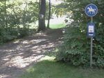
| |
| Feeding station | amenity=feeding_place feeding:for=horse feeding:type=automated feeding:fodder=* |
An automated feeding station to provide fodder. | 
| |
| Field shelter | amenity=shelter shelter_type=field_shelter access=private (if necessary) |
A shelter to provide protection against bad weather conditions. As those shelters are usually not freely accessible the tag access=private might be appropriate. | 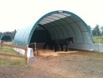
| |
| Ford | ford=yes | A shallow place with good footing where a river or stream may be crossed by wading or in a vehicle. | 
| |
| Guidepost Signpost |
tourism=information information=guidepost horse=yes |
A guidepost / signpost with information for horse riders. | 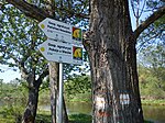
| |
| Horse boarding | amenity=animal_boarding animal_boarding=horse |
A boarding facility for horses. | 
| |
| Horse stile | barrier=horse_stile | A horse stile allows pedestrians and horses to cross a gap through a fence, but prevents or makes it very difficult for motorcycles, riderless horses and other live stock to cross. | 
| |
| Horse walker | animal=horse_walker | A horse walker is used for exercising horses or to cool them down after training (so called hot walker). | 
| |
| Manger Cratch |
amenity=feeding_place feeding:for=horse feeding:type=manger feeding:fodder=hay |
A manger to provide hay as fodder. | 
| |
| Map | tourism=information information=map horse=yes |
A board with a map that shows features related to horse riding. | 
| |
| Open stable | landuse=animal_keeping animal_keeping=horse animal_keeping:type=open_stable |
A fenced area where horses are kept, but can move freely and food and water is provided. The horses may stay in the open stable the whole time. The fence can be tagged using barrier=fence and fence_type=*. | 
| |
| Paddock | landuse=animal_keeping animal_keeping=horse animal_keeping:type=paddock |
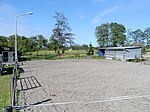
A paddock is a fenced area to keep horses but does not allow for grazing. The surface is either very low cut grass or a layer of sand or similar material. In order to keep the surface suitable usually a drainage is necessary. The fence can be tagged using barrier=fence and fence_type=*. The main difference to a pasture, which is also called paddock in some regions, is that a paddock does not allow grazing and possesses a drainage. |
| |
| Paddock box | landuse=animal_keeping animal_keeping=horse animal_keeping:type=paddock used for the open-air area see Stable for the building |
A paddock box is a stall (box) for a horse with a very small adjacent outdoor enclosure which grants access to the open air but does not allow grazing. A paddock box is tagged just like a stable with an adjacent paddock area. | 
| |
| Pasture (Paddock) |
landuse=meadow meadow=pasture (undocumented) and optional landcover=grass |
Pasture - sometimes also called paddock - is a fenced area mainly used for grazing. The fence can be tagged using barrier=fence and fence_type=*. If the area is not suitable for grazing, see Paddock. |

| |
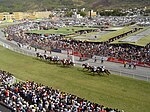
| Racecourse |
leisure=track |
A |
| |
| Riding hall | building=riding_hall sport=equestrian additional if appropriate |
A building that was built as a |

| |
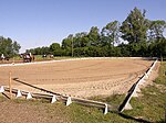
| Riding school / arena / pen | leisure=pitch sport=equestrian building=* additional if within a building |
A |
| |
| Riding stable | leisure=horse_riding | An |

| |
| Stable | building=stable if the whole building is used as a stable building:use=stable if only a part of the building is used as a stable |
A stable is a building in which horses are kept. It most commonly means a building that is divided into separate stalls for individual animals. If the whole building is used as a stable, use the tag building=stable. Otherwise, if only part of the building is used, map this part separately and only apply the tag building:use=stable. | 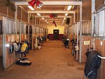
| |
| Trail riding station | tourism=trail_riding_station if only used as trail riding station tourism=* |
A station that offers temporary accomodation for guest horses and usually also for riders. | 
| |
| Veterinary for horses | amenity=veterinary veterinary=* veterinary:for:horse=yes |
A place where a veterinary treats horses. The size of the facility can be specified as veterinary=practice, veterinary=clinic or veterinary=hospital. | 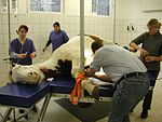
| |
| Watering place | amenity=watering_place | A place where water is contained and animals can drink. | 
|
Riding routes
Officially marked riding routes can be mapped using a relation with the type route and the key route=horse. The tag (horse=designated) might be used to specify recommend routes for horse riding, although there is no wide consensus on this.
horse_scale describing the difficulty of the way
horse_scale is a system describing the difficulty of ways for horse riding (similar to sac_scale for hikers or mtbscale for bikes).
The horse_scale tag can be applied to any special part of a way - especially bridges. If you tag a way you should give the whole way the value of the part with highest horse_scale along the way because the most difficult part limits the usability of the way.
The horse=no tag defines that it is legally prohibited to ride a way. Sometimes horse=no is used erroneously to indicate that the way is unsuitable or dangerous to ride. Then it should be substituted by a "horse_scale" tag.
| Tag | Description |
|---|---|
| horse_scale=common | riding is easy, way is smooth and wide. The default, used to indicate that the way is checked regarding horse issues. |
| horse_scale=demanding | Caution required. Some parts of the way are demanding. Uneven surface. Caution and a skillful horse are required. |
| horse_scale=difficult | Narrow and possibly steep drops to the sides. May have barriers like trees or narrow constrictions. Difficult to pass for big horses. Can usually be passed riding. |
| horse_scale=critical | Very narrow and demanding. Only for trained and experienced horses and riders. Usually passed walking and leading the horse. Bridges should be checked for capacity and condition. |
| horse_scale=dangerous | Difficult, winding and dangerous. Only possible for very experienced horses and riders in good weather, usually leading the horses. Obstacles impassable for average horses. |
| horse_scale=impossible | Completely impassable for horses, deadly peril. Obstacles like ladders or climbing spots with fixed ropes. Too narrow or low for horses. Unstable or narrow bridges, danger of collapse or drop. |
The best documentation of this tag is in german language https://wiki.openstreetmap.org/wiki/Reiten
Historically the values horse=critical and horse=unsuitable were sometimes used to specify a way as problematic or impossible for horsemen. They are deprecated and should not longer be used.
Other useful features
The following features are not directly related to riding but usually also useful when mapping related features:
- surface=* can be used to specify the surface of ways.
- smoothness=* specifies the smoothness of the surface of a way, i.e. how even the way is
- incline=* marks the steepness/slope of a way
- barrier=* is used to map all kinds of barriers
- width=* specifies the width of a way
- trail_visibility=* is used to give a rough estimation how visible a trail is on the ground