JA:Tag:waterway=riverbank
| 説明 |
|---|
| エリアとして定義付けされる幅広い河川。 |
| OSM Cartoでのレンダリング |

|
| グループ: 水域 |
| 適用できる要素 |
| 関連項目 |
| 状態:非推奨 |
| ツール |
英語版の記事の内容が分かる方は、翻訳の完成にご協力ください。このウィキの翻訳方法についての説明をお読みください。
現時点では、誰もこの記事の翻訳に取り組んでいないようですので、あなたが取り組めます。
ここでは大規模な河川や、水や川岸の領域を識別できるマッピングが「必要」となる程度の幅がある川の区間のタグ付け方式について説明します。例えば、ロンドン中心部を流れるテムズ川などです。
小さな川については、河川のエリアを描く必要はありませんが、特に例外的な場合もあるのでそれでも興味深いでしょう。
マッピング方法
河川の領域は川岸に沿って引かれた閉じたウェイ(この場合エリアを表わします)で囲み、両端を繋げます(ウェイの最後のノードが最初のノードでもある)。実際には、広い川は長い傾向にあり、適切なエリアの連続(上記画像中のウェイ1と3)として川は描かれます。
これらの水域のエリアは、 waterway=riverbank または natural=water + water=river のどちらかでタグ付けしてください。
waterway=riverbank の使用は natural=water + water=river の代用で、以前から幅広く使用が残っており、一部のマッパーに好まれています。
加えて(より小さな河川の場合と同様に)、 waterway=river とタグ付けされたウェイ(上記画像のウェイ4)は、河川の流れの方向(すなわち水源地から海)に描く必要があります。 ![]() thalweg か川底の最も深い点に沿って描くのが理想です。この正しい位置を特定するのは難しいので、ふつうは正しい経路に沿ったできるだけ正しい位置にすれば結構です。このようなウェイは highway=* タグのように、正しい形状になるようにしてください。
thalweg か川底の最も深い点に沿って描くのが理想です。この正しい位置を特定するのは難しいので、ふつうは正しい経路に沿ったできるだけ正しい位置にすれば結構です。このようなウェイは highway=* タグのように、正しい形状になるようにしてください。
禁止事項
- 両方の方式でオブジェクトをタグ付けすること(waterway=riverbank+natural=water)
- natural=water で親リレーションをタグ付けすること
- 意味もなく waterway=riverbank を natural=water タグ付け方式に(またはその逆に)置き換えること。そうすると非常にややこしくなり、簡単にはわからず品質管理ツールで報告されないエラーの原因になります。例えば、 natural=riverbank/natural=water は親や子のリレーションと一貫していなければなりません。
島
河川の島をマッピングするには、マルチポリゴンリレーションを使用できます。島と中心的な河川の岸はリレーションに含める必要があります。中心的な riverbank ウェイ(上記画像のウェイ1)は 'outer' ロールを持ち、島のウェイ(上記画像のウェイ2)は 'inner' ロールを持ちます。マルチポリゴンリレーションを使用してマッピングする場合は、メンバーのウェイにwaterway=riverbankもタグ付けしないでください。これは間違っています。それ自身が別の意味を持たない限り(barrier=retaining_wallのように)、メンバーのウェイはタグなしにすべきです。
河岸のマッピングのためのマルチポリゴンリレーションの大きさの選択
Occasionally mappers have assembled very large multipolygon relations covering the whole extent of the river in one relation. This causes a lot of problems, in particular
- editing and validating edits becomes very difficult for the mapper due to the volume of data involved.
- there is a strong likelihood of mapping conflicts in areas with frequent mapping activity when for example mappers several hundred kilometers apart try to edit the riverbank at the same time
- large and complex multipolygons break much more often than smaller ones and the effect of a broken multipolygon is much more severe than with a smaller granularity of mapping
- processing the data is more complicated and inefficient for data users.
- quality control and evaluation of edits of such large multipolygons is more difficult.
Because of these problems and because at the same time multipolygons for the entire river offer no tangible advantages, but place an unnecessary burden on data consumers, they should not be used. Use multiple small multipolygons or closed ways as described above instead.(議論を参照)This is also common practice followed by most mappers.
The established way to represent a named river as a whole in OpenStreetMap is through waterway relations.
人工の水路
大運河のエリアは歴史的には waterway=riverbank でマッピングされることもありましたが、曖昧さを回避するため現在は natural=water + water=canal が優先的に使用されています。
河川の結合
ウェイ1と2は常に waterway=river タグと、追加のタグ name=* が付けられます。両者が接続されていることも確認してください。これは船の経路やその他の河川の接続分析で重要になります。
河川の本体にはいくつかの可能なアプローチがあります。
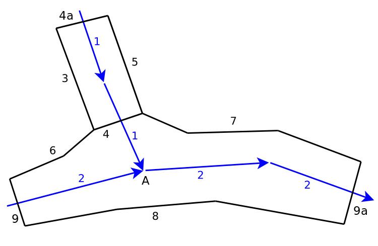
- Simple tagging on ways - Rivers like this can be mapped with simple closed ways
 where 3,4 and 5 would all be the same way, with an additional section closing the loop at the top somewhere, and the tag waterway=riverbank or natural=water+water=river. Likewise 6,4,7,8 and some additional closing segments would be mapped as a single closed way. The section at 4 would be sharing the same nodes in both ways.
 - Multipolygon relations - Rather than closed ways you can use Relation:multipolygons
 , containing the ways 4 and 6 to 8 for the horizontal river, and 3 to 5 for the vertical river. Multipolygons are more complex but have some advantages. They can be bigger, and they can exclude islands areas ('inner'). The tags would be: type=multipolygon + waterway=riverbank
The above two approaches have an inaccuracy, because the way between the two rivers in a junction (number 4) isn't a riverbank, so it ideally shouldn't be tagged as one either.
河川の水位変化
多くの河川は時間と共に水位が結構変化しますので、正確に水面と地面の境界として描くべき場所を決定することは困難です。参照すべき水位についての決定的な合意はありませんが、助けになるいくつかのガイドラインは存在します。
- 水位に干満の変化がある河川の場合、natural=coastlineの場合と同じく、満潮の水位をマッピングするべきです。
- 水位が結構変化するのが場合(著しい氾濫の場合を除く)、一般に低水位より高水位をマッピングするほうが良いです。
- よくある場合として、例えばモンスーンの時期や雪解けの間など比較的短い期間だけとても高水位で一年のそれ以外は低いか比較的一定の水位という季節的な氾濫の影響を受ける河川の場合、氾濫の時期の水の広がりをマッピングしないほうがより良いでしょう。一般的なおおまかなやり方は一年のすべての月の最高水位の中央値をマッピングすることです。氾濫の時期に水で覆われる領域に対しては、Proposed features/floodplainやJA:Key:flood_proneのようなタグ付けをするアイディアがあります。
- 一年のほとんどにおいてそれなりに一定の水位の河川では、実際にはかなり低水位の乾季であったとしても、たいてい明瞭に目に見える(とはいうものの時々変化する)河川敷が普段の河川の広がりを示します。
- 間欠河川の場合、河川が枯れていない時期の川の広がりをマッピングし、intermittent=yesを付けるのが合理的です。灌漑やほかの目的で河川が逸れている領域は、たいてい雨季の時期でも河川敷は水で満たされないので、注意してください。
一般的に、もしより良いデータ(できれば、地域に住んでいる誰かが河川の位置を観察したもの)があると、これらのルールにより接近することになります。航空画像から描く場合、見た目だけに基づいて描いても構いません(つまり、以下の写真に見られる見える砂州は水面下になると想定する)。なお、航空画像から描かれた情報で、価値のある地上のマッピングを上書きしないように常に注意を払ってください。
川床
natural=riverbed は河床の範囲を定義するためにときどき使われます。
河川中の島と砂州
河川の中で永続的でなく容易に変化する島(砂州)はマッピングしないというのが一般的な手法です。河川中の中州が植物で覆われていることが永続的であることの指標として使われる場合もありますが、間違いかもしれません。植物が生えていなくても、長年安定的に存在する中洲の例はたくさんあります。航空写真や衛星写真からマッピングする場合、他の年の写真との比較がとても役に立ちます。
制限
制限は waterway=river でタグ付けされた中央のウェイに設定してください。
riverbank マッピングのヒント
This describes how to use the "create parallel way" tool in Potlatch 2 to create a riverbank from a river. This method works best when mapping a section of river that has a consistent width and each side of the riverbank is nearly identical in shape.
- 川の中心に waterway=river を作成する
- Select a section of the river that has a consistent width
- Select the parallel tool or type "p"
- Adjust the new parallel way's distance from the original way so the new way is half the width of the river (zooming in helps)
- Create a parallel way on the opposite side of the original river
- Label both new ways identically as waterway=riverbank
- Connect the ends of each new riverbank to create a closed loop
- Use the "merge ways" tool to merge these into a single way representing the riverbank area.


