Proposal:Traffic island
| Traffic island | |
|---|---|
| Proposal status: | Abandoned (inactive) |
| Proposed by: | Lulu-Ann |
| Tagging: | landuse=traffic_island
|
| Applies to: | |
| Definition: | A traffic island is a small area that separates highways and pedestrians allowed to walk here. |
| Statistics: |
|
| Draft started: | 2010-04-08 |
- The tag
highway=traffic_islandshall improve the description of large intersections.
- But by the definition above, a traffic island is not a highway.
- It ought to be combined with crossings tagged as specifications of footways and cycleways instead of being marked as nodes.
Rationale
The tag highway=traffic_island can be helpful to map the real number of sections of a pedestrian or bicycle crossing, whereas the crossing nodes show the passage more complicated than it is.
Up to now it is possible to tag a traffic island as a puzzle of landuse=grass and highway=footway areas, but many traffic islands also comprise paved areas that are not traffic space, and waiting positions for cyclists on a traffic island are neighter a footway, nor a bikebox that could be tagged as highway=asl.
An item similar to highway=traffic_island was used with highway=platform, before it was considered that it is better to tag public_transport=platform
Prerequisites
- Consider mapping highways as separate way per traffic direction.
- It is possible that footways, cycleways, or road lanes go across a traffic island.
- Traffic islands have different types of kerbs. They might be passable for wheelchair users or not, and they might be high enough to be detected by a blind person with a white cane or not.
- Traffic islands might have different surfaces.
- Traffic islands might have poles of traffic lights on them, button operated or not.
- Traffic islands can be passable for pedestrians or not. They can be middle rest of a zebra crossing, an uncontrolled crossing, a tucan crossing...
Examples with images
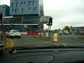
The setting of the third photo (53.071303 N|8.801245 E) may be mapped as follows:
- two
highway=traffic_island. - three
highway=footway+crossing=traffic_signalseach.- If
kerb:height=*orkerb=*is tagged with the crossing footways or with the islands or with nodes for each single kerb, depends on equal or different values.
- If
- one
highway=cycleway+crossing=traffic_signals+oneway=yes+kerb:height=*.
-
 Type A
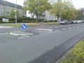
 -
 Traffic island at a Junction. Without tactile paving, but has a lowered kerb.
 -
 The cycle crossing traverses two carriageways and a rail junction with four tram tracks in one passage. The foot crossing on the right is divided into three sections by two traffic islands, each between a carriageway and the tram tracks.


Where the crossings are for foot and bike together without segregation, it seems better to tag the drawn lines highway=crossing + access tags.
Rendering
- Edge - Roadcontoure lines. TBD.
- Filling - similar to
highway=pedestrian+area=yes
Routing
- 'foot' routers should treat them as
highway=pedestrian+area=yes