Tag:landuse=grass
Jump to navigation
Jump to search
| Description |
|---|
| A smaller area of grass, usually mown and managed. |
| Rendering in OSM Carto |

|
| Group: landuse |
| Used on these elements |
| See also |
| Status: de facto |
| Tools for this tag |
|
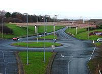
A tag for a smaller areas of mown and managed grass for example in the middle of a roundabout, verges beside a road or in the middle of a dual carriageway.
There are also many instances of landuse=grass used for any areas of grass - for example patches of grass between tracks in railway corridor within area tagged with landuse=railway, or lawns within residential areas. This usage is considered controversial by some mappers.
More specific tags
There are often more appropriate tags for areas of grass. These include:
- leisure=dog_park An area reserved for dogs to run, often off the leash.
- leisure=garden An area managed as a private or public garden with flowers, bushes, etc.
- leisure=golf_course An area within which golf is played. See also: golf=green, golf=fairway, golf=rough.
- leisure=park An area set aside for public recreation within an urban area.
- leisure=pitch An area formally organised for a particular sport: tennis, soccer, etc.
- natural=grassland Areas where the vegetation is dominated by grasses and other herbaceous, non-woody plants.
- landuse=farmland with produce=turf where grass is harvested for transplant elsewhere.
- landuse=meadow for farmland which is sown with grass for grazing or for hay.
- landuse=recreation_ground An area predominately designed for formal or informal sports and fun.
- landuse=village_green A public space, typically associated with a village.
Other similar tags:
- natural=heath - for areas of dwarf shrubs and low bushes
- natural=scrub - for areas of shrubs and bushes
- natural=wetland - for wetlands, including grassy marshes and fens (wetland=marsh, wetland=saltmarsh, wetland=bog, wetland=fen)
- landcover=grass - alternative proposal to deprecate this tag (since landuse=grass isn't considered landuse in the traditional sense)
As an add-on tag for other features:
Possible tagging mistakes
| ||||||||||||||||||||||||||||||||
