GpsPrune
| GpsPrune | ||||||||||||||||||||||||||||||||||||||||||||||||||||||||||||||||||||||||||||||||||||||||||||||||||||||||
|---|---|---|---|---|---|---|---|---|---|---|---|---|---|---|---|---|---|---|---|---|---|---|---|---|---|---|---|---|---|---|---|---|---|---|---|---|---|---|---|---|---|---|---|---|---|---|---|---|---|---|---|---|---|---|---|---|---|---|---|---|---|---|---|---|---|---|---|---|---|---|---|---|---|---|---|---|---|---|---|---|---|---|---|---|---|---|---|---|---|---|---|---|---|---|---|---|---|---|---|---|---|---|---|---|
| Author: | activityworkshop.net | |||||||||||||||||||||||||||||||||||||||||||||||||||||||||||||||||||||||||||||||||||||||||||||||||||||||
| License: | GNU GPL (free of charge) | |||||||||||||||||||||||||||||||||||||||||||||||||||||||||||||||||||||||||||||||||||||||||||||||||||||||
| Platforms: | Windows, Linux, and macOS | |||||||||||||||||||||||||||||||||||||||||||||||||||||||||||||||||||||||||||||||||||||||||||||||||||||||
| Version: | 25.1 (2025-03-01) | |||||||||||||||||||||||||||||||||||||||||||||||||||||||||||||||||||||||||||||||||||||||||||||||||||||||
| Languages: | ||||||||||||||||||||||||||||||||||||||||||||||||||||||||||||||||||||||||||||||||||||||||||||||||||||||||
| Website: | http://gpsprune.activityworkshop.net/ | |||||||||||||||||||||||||||||||||||||||||||||||||||||||||||||||||||||||||||||||||||||||||||||||||||||||
| Source code: | https://github.com/activityworkshop/GpsPrune | |||||||||||||||||||||||||||||||||||||||||||||||||||||||||||||||||||||||||||||||||||||||||||||||||||||||
| Programming language: | Java | |||||||||||||||||||||||||||||||||||||||||||||||||||||||||||||||||||||||||||||||||||||||||||||||||||||||
|
Track editor, analyser, creator and converter |
||||||||||||||||||||||||||||||||||||||||||||||||||||||||||||||||||||||||||||||||||||||||||||||||||||||||
| ||||||||||||||||||||||||||||||||||||||||||||||||||||||||||||||||||||||||||||||||||||||||||||||||||||||||
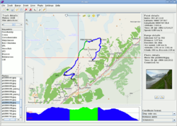
GpsPrune is a free, open source, cross-platform program to view and edit spatial data like GPS tracks. It shows tracks and waypoints overlaid on top of OSM maps and can convert between popular data formats, as well as being able to correlate photos with the GPS data.
It's written in Java and runs on Windows, Linux, Mac OSX and Solaris. The supported languages are Czech, Dutch, English, French, German, Hungarian, Spanish, Italian, Polish, Portuguese, Chinese, Japanese, Korean and Russian. Further languages are partially supported, including Turkish, Afrikaans, Romanian and Ukrainian.
Link: http://gpsprune.activityworkshop.net/
More screenshots: http://gpsprune.activityworkshop.net/screenshots.html
Features
- Loading data from file (see supported formats below) or from GPS receivers using GPSBabel
- Viewing data with a map view using OSM maps (mapnik by default, other renderers configurable such as OpenCycleMap)
- Altitude profile view, speed plot, details like distances, durations, speeds and altitude differences
- Interactive 3D view using java3d including map overlaid on terrain
- Editing data (delete individual points or sections, variable compression, combine and rearrange data, create and edit individual points)
- Exporting data to file, sending data to GPS receiver
- Geotagging photos (manually or automatically using timestamps)
- Exporting photo thumbnails to kmz format, and saving coordinates in photo files using ExifTool
- Geotagging audio files
- Charting (eg altitude against time, speed against distance) either on screen or output to svg file
- Lookup of altitude data for track coordinates using SRTM data
- Lookup of coordinates from wikipedia
- Download from and upload to gpsies.com.
- Weather forecasts from OpenWeatherMap
Supported file formats
GpsPrune can read files in the following formats:
- text or csv, using fields in any order and with any delimiter
- gpx, including zipped and gzipped gpx files
- kml, including zipped and gzipped kml files and kmz files
- nmea files
Also, GpsPrune can use GPSBabel to import many more file types, optionally using GPSBabel's filters.
GpsPrune can also save data to files in the following formats:
- text or csv, using fields in any order and with any delimiter
- gpx files
- kml and kmz files (kmz files can include photo thumbnails)
- 3d model in povray format for scene rendering, including surrounding terrain
- 3d view in svg format
Installation
GpsPrune is available for free download as a jar file, which is runnable without installation. Certain linux distributions (such as Debian and Ubuntu) provide a package for GpsPrune within their packaging systems, so it's available directly from the software manager. Just search for "GpsPrune" and select to install it.
Additional software
Not mandatory, but adds some features:
- Java3d library — for "Three-D view"
- gnuplot — for a charts
| ||||||||||||||||||||||||||||||||||
