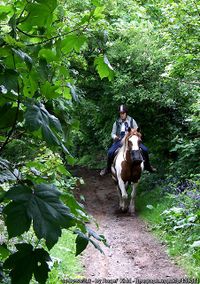
Tag:highway=bridleway
| Description |
|---|
| A way intended for use by equestrians. |
| Rendering in OSM Carto |

|
| Group: highways |
| Used on these elements |
| Implies |
| Useful combination |
|
| See also |
| Status: de facto |
| Tools for this tag |
|
A way intended for use by horse riders (primarily) and pedestrians (depending on country-specific regulations). They may be legally designated as rights of way for pedestrians and equestrians (horses), but need not be. Depending on the country, cyclists may be also permitted, though the surface may not be suitable.
How to map
To map a bridleway nothing else than a simple way is required. Add the highway=bridleway tag to it. You can also add a name=* and ref=* if appropriate.
Country-dependent regulations
England and Wales: public bridleways
- Main article: UK access provisions § England and Wales
Many bridleways in England and Wales are rights of way, legally designated as public bridleways: this gives a right to travel on foot or with a horse.
Cyclists also have a right, unless the local authority makes orders to the contrary. (Where this is the case bridleways are usually signed "no cycles".) The local authority is not obliged to ensure suitability for bicycles, unlike for foot or horse users.
In England & Wales a bridleway (the physical feature) should be tagged highway=bridleway, as in the general case detailed above.
Bridleways that are also "public bridleways" should be additionally tagged designation=public_bridleway in order to indicate the legal right of way.
Occasionally, ways that are not physically bridleways are designated as public bridleways, such as when a right to travel by foot and by horse passes along an otherwise private way (often, a farm track). In these cases the physical feature should have whatever highway=* tag is the best fit for the physical reality, with the right of way indicated by designation=public_bridleway as above.
Germany: public ways vs. forests/farmland
In Germany, bridleways on public land are regulated by the traffic code (Straßenverkehrsordnung). The blue sign StVO 238 designates a way for riding only. Thus use by pedestrians, bicycles and motor vehicles is excluded, unless additional permission is given by additional signage.
Only those public bridleways should be tagged with highway=bridleway.
On the other hand, in forests and on farmland the access is regulated by individual law in the federal states. Often, riding is generally prohibited in forests, and only allowed individually on particular ways. This would be posted, e.g., on small signs along these ways.
Thus, as usage for riding is a subordinated aspect on such forestry ways, they should not be tagged as bridleways, but instead as highway=track, if they can be used by two-track (forestry) vehicles, otherwise as highway=path. In addition, the access by horse is given with the tag horse=yes. Further details of the state-specific regulation can be found on ![]() Reitrecht.
Reitrecht.
See also
- For the different access=*-defaults see Access-Restrictions
- For routes designed to go by horse see the route relation with the tags route=horse and network=*.
| ||||||||||||||||||||||||||||||


