User:EdLoach/TMFP Cycleway
Tabbed Map Features
Testing idea of having a "tabbed" map features, rather than one big page. Not fully implemented. Got to stage of realising there would be lots of pages to maintain, at least setting up initially, even only in English.
| Map Features | Physical | Non Physical | Naming | Annotation | Editor Keys |
|---|
| Physical | Highway | Barrier | Cycleway | Tracktype | Waterway | Railway | Aeroway | Aerialway | Power | Man Made | Leisure | Amenity | Office | Shop | Emergency | Tourism | Historic | Landuse | Military | Natural | Geological |
|---|
Cycleway
To describe infrastructure designed mainly for cyclists. See also: Cycle routes.
| Value | Element | Comment | Photo | |||
|---|---|---|---|---|---|---|
Dedicated bicycle lanes | ||||||
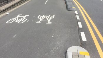
| lane | A bicycle lane is an inherent part of the road itself. It has no physical separation from the other lanes except the painting on the road. In North America, known as a class II bicycle facility. Notably, there is no curb between the cycle lane and the road.
Some countries have two different types of cycle lanes:
To distinguish between these two types of cycle lanes, the cycle lane can additionally be tagged with cycleway:lane=exclusive or cycleway:lane=advisory respectively.
|
|||||
|
| ||||||
| shared_lane | Cyclists share a lane with motor vehicles, and there are markings (like The road markings are usually there to highlight a cycle route or to remind drivers that you can cycle there. |
|||||
| share_busway | A special lane reserved for public transport on which cyclists are also allowed to bike. | |||||
Bicycle tracks | ||||||
| track | A cycle track is separated from the road by curbs, parking lots, grass verges, trees, bollards or another physical barrier, but is running parallel and next to the road. In North America this is called a protected bike lane, separated bike lane, greenway, green lane, or class IV facility.[1]
Alternatively, consider mapping cycle tracks as a separate way next to the road tagged as highway=cycleway (or highway=path + bicycle=designated in case of shared foot- and bicycle ways). Both methods each have their pros and cons: While adding a single tag to an existing way takes less time and still often describes the cycle track accurately, a separately tagged cycle way is generally more flexible and allows to capture more detail (note here that higher complexity increases the potential for routing errors). Add cycleway=separate to the highway if a cycle track is mapped separately (see below). In the USA, general practice is to use this tag when the bike lane is protected by parking with or without bollards/flex posts. E.g. the parking lane is between the vehicle travel lane and the bike lane. Where the bike lane is bi-directional and protected by bollards, general practice has been to draw this bike lane as a separate way even if it is not vertically separated from the vehicle travel lanes. |
|||||
| separate | Should be used to indicate that a cycle track associated with a highway has been mapped as a separate OSM element (i.e., is tagged with highway=cycleway). Meaning is similar to the use of sidewalk=separate for footways, and can potentially be used when simplifying geometries for rendering. It also acts as a hint to avoid duplicating an existing cycleway by adding cycleway=track to a highway. Don't confuse with segregated=yes. | |||||
No bicycle infrastructure | ||||||
| no | Explicitly marks that a street has no bicycle infrastructure. This allows to explicitly note that the road was surveyed for bicycle infrastructure. | |||||
Other bicycle infrastructure | ||||||
| crossing | Used on separately mapped paths to indicate that it's a bicycle crossing. | |||||
| shoulder | Used to indicate that a road has no designated infrastructure for cyclists, but shoulders (a.k.a. breakdown lanes) are navigable and legal to cycle on. Especially on rural roads with high speed limits, the existence of a shoulder usable by cyclists can make the difference whether the road is usable at all (semi-)safely for cyclists. Not every shoulder=* is automatically usable for cyclists: Some shoulders are used for parking (parking=shoulder) instead, not all shoulders are paved (with asphalt, e.g. grass pavers). Additionally, shoulder=yes is typically only mapped for shoulders that are broad enough to accommodate a car. For cyclists however, a less wide shoulder is fine, too. | |||||
| link | A connector between OSM segments for cycle traffic, for example to connect a separately mapped cycle path to a junction on the opposite side. Serves primarily as a routing aid and does not necessarily have to be identifiable as built infrastructure. | |||||
| traffic_island | Used on the parts of refugee islands of a cycleway=crossing. | |||||
| asl | Indicates an advanced stop line or bike box at junctions. Use cycleway=asl on a |
|||||
| gap_jump | A gap jump segment of MTB downhill route. Generally would consist of two or three parts: a take-off ramp; a physically non-existent mid-air segment; and optionally a landing ramp (if not present, a regular bike track serves as a landing zone). The mid-air segment may cross other roads or features, in which case it should be tagged with layer=1 without a node at the intersection; surface=none has occasionally been added as well. Consider explicitly providing foot=no or access=no + bicycle=designated in order to prevent routing for any other activity. | |||||
Deprecated or discouraged tags | ||||||
| Formerly used in one-way roads before oneway:bicycle=* was used. See below how to map bicycle infrastructure in one-way roads. | ||||||
| Formerly used on cycleways which were mapped as separate ways tagged as highway=cycleway before the segregated=* tag was formalized. Its use with highway=cycleway is now considered obsolete. | ||||||
This table is a wiki template with a default description in English. Editable here.


