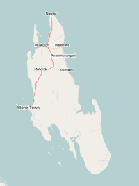
Zanzibar
| V・T・E |
| latitude: -5.6719, longitude: 39.5289 boundary: 37750353775035 |
| Browse map of Zanzibar 5°40′18.84″ S, 39°31′44.04″ E |
| Edit map |

|
|
External links:
|
| Use this template for your locality |
Zanzibar is a semi-autonomous zone and archipelago in Tanzania at latitude 5°40′18.84″ South, longitude 39°31′44.04″ East.
Nic started the map after a week long visit to the northern half of the main island (Unguja).
Regions and priorities
Zanzibar architecture
Zanzibar is famous for its unique architecture.
OpenStreetMap will capture this unique history using the following tagging guidelines (this part of the page is under a lot of editing, this is a very very rough first list of features used):
First, the basis of mapping architecture can be found on the OSM Buildings page. Keys that need special attention are:
- man_made=courtyard proposed tag for courtyards
- architect=* to indicate the architect of a building
- building:condition=* for the condition of the building
- ruins=* - for ruins of buildings
- abandoned=* - for a building which has been abandoned by its owner and is no longer maintained
- start_date=* - the year of construction. If the date is unclear, a Date Range can be used.
- building:architecture=* - According to
 Architectural_style characterizes a building by the features that make it notable and historically identifiable. Could this be extended with 'Zanzibar House'?
 - historic=* - If a building has an historic significance. eg. historic=city_gate
- historic=* - If a building has an historic significance. eg. historic=city_gate
Example:
- ref:whc 1055
- whc:criteria (ii)(iv)(vi)
- whc:inscription_date 2001
Additional tags:
- website=* - For official websites eg. ministries or companies.
- wikidata=* - For features that have their own Wikidata page, this allows computers to merge in data (for example pictures) from wikipedia.
- wikipedia=* - For features that have their own Wikipedia page, this allows sites to clearly link to Wikipedia when relevant.
- tourism=* - To indicate this building is interesting for tourists.
Stone Town
The old Stone Town area (now part of Zanzibar City to the west of Creek Road) is a UNESCO world heritage.
Ng'Ambo
The Ng'Ambo area is planned to be the new City Centre. In order to support the development of the plan, a good map of the current situation, but also of the way that Ng'Ambo has developed over time is required.
The government of Zanzibar is in the process of creating this map as a basis for a new city plan for Ng'Ambo. (We can add this plan to the list on this page.
Other areas
There is keen interest to enhance the quality of the map in the more rural areas of Zanzibar as well.
Public transport
In Dar es Salaam a lot of work has been done all the DalaDala routes. The mapping guidelines used there are also applicable on Zanzibar.
Special OSM maps relevant for Zanzibar
- Stone Town and Ng'ambo in 3D on F4map. And here a corner where some houses have colour and roofshapes defined OSMBuildings.org and OpenScienceMap and in the Open Source tool ViziCities
- Historical Map of Zanzibar. based on the tag * historic=*.
- Touristic map of Stone Town rendered by HikeBikeMap.
- Electrical Infrastructure
- Public Transport that renders Dala Dala and Another example
- Skobbler allows users to search for types of points. The link shows museums in Zanzibar Town.
- Wikipedia Articles on the map (not updated since oct-2015) . We need to create a polygon with a Wikipedia link to see how that works.
- Fix Errors on the map, map overlays possible errors.
- OpenLinkMap, shows overlay of features with Links or opening times.
- Before and After map of Ng'ambo. (Though it is not quite clear what Before means)
Zanzibar projects
NGT project
The NGT project requires maps of the above. This will require a lot of fieldwork, where some of the tagging is quite specific, so we developed several guidlines:
- Zanzibar Building Tagging Guidelines
- Zanzibar POI Tagging Guidelines
- Zanzibar Typology QGIS Map Guidelines
Zanzibar coastal sensitivity mapping
Coastal sensitivity mapping in Zanzibar is the projects which aims to conduct data collection by digitize all sensitivity features in the oceans and in the main land not far than one kilometre.
