Japan tagging
Japan tagging is a guideline for tagging Japan-specific features. See Map Features for common features not explained below. See also Japan for basic information. JA:Naming sample and JA:Howto Map A will be also the reference for examples of tagging.
Unlike general articles, the Japanese version is the original for Japan tagging. If you want to change the guideline, please ask on talk-ja mailing list.
Highway
Road types
In Japan, there are pre-defined tags for each element -- these are listed in the "Implies" column. If a road does not match that column, tweak the relevant tags.
| Key | Value | Element | Comment | Example | Typical image | Useful combination | Implies |
|---|---|---|---|---|---|---|---|
| highway | motorway | Expressways or motor roads. If you see a sign drawn a white car in blue background: |

Tomei Expressway, Shuto Expressway, Hachioji Bypass, Hakone Turnpike. |
| |||
| highway | motorway_link | The link roads (sliproads / ramps) leading to and from a motorway. Normally with the same motorway restrictions. | 
|
| |||
| highway | motorway_junction | Indicates a junction or exit ref should be set to the exit number or junction identifier. | 
|
||||
| highway | trunk | National highways excluding expressways and motorways. Usually, National highways have blue triangle shield signs: Note that a little part of Japanese National highways have regions which cannot be accessed by motor vehicles, for example, steps, a pedestrian, a hiking way, or a ferry route. Those region should be tagged by other highway tags and add it to Relation:route with route=road and ref=number. |

|
||||
| highway | trunk_link | The link roads (sliproads / ramps) leading to and from a trunk road. | |||||
| highway | primary | Major Prefectural road, numbered with one or two digits and maintained by the prefecture. If you see a hexagonal shield sign, A region of expressway, motorway or road that cannot be accessed by motor vehicles should be tagged using other highway tags and added to Relation:route with route=road and ref=number. |

Hokkaido Route 1, Tokyo Route 318. |
||||
| highway | primary_link | The link roads (sliproads / ramps) leading to and from a primary road. | |||||
| highway | secondary | Minor Prefectural road, numbered with three digits and maintained by the prefecture. If you see a hexagonal shield sign A region of the road that cannot be accessed by motor vehicles should be tagged by other highway tags and added to Relation:route with route=road and ref=number. |

|
||||
| highway | secondary_link | The link roads (sliproads / ramps) leading to and from a secondary road. | |||||
| highway | tertiary | For 2 lane roads (1 lane each way and drawn a center line, or 2 lanes one way) within a shi (city), a machi (town) or a mura (village). This should not be a major (motorway, motorway_link, trunk, trunk_link, primary, primary_link, secondary, or secondary_link) road or a residential road. | 
|
||||
| highway | tertiary_link | The link roads (sliproads / ramps) leading to and from a tertiary road. | |||||
| highway | unclassified | Narrow and paved roads, less than 2 lanes. This includes low grade roads, provided they are important to interconnect the grid network. This should not be a residential road. | 
|
||||
| highway | residential | For roads within a residential area, public facility, compound, or private area. Typically, this is not a road designed for driving through an area, but rather for driving to it. | 
|
||||
| highway | service | Service roads. parking aisles, roads in a park, roads in industrial factory, etc. | |||||
| highway | pedestrian | For roads used mainly or exclusively for pedestrians. For example, shopping streets, or pedestrian roads in universities or big parks. You can see |

|
||||
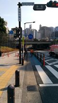
| highway | cycleway | Separate ways for the exclusive use of cyclists. You can see a sign |
|
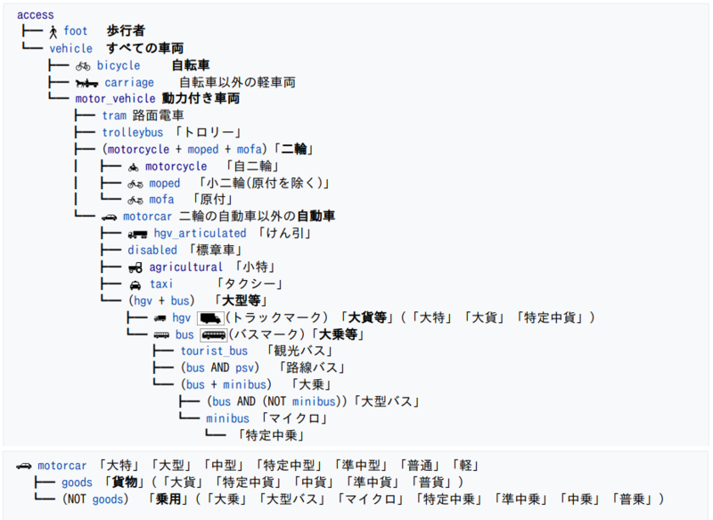
自転車以外の'軽車両'や'小型特殊自動車'に関しては、標識等で通行を許可/禁止する表示がある場合に限り
|
|||
| highway | footway | Footways, mainly in cities and paved. You can see |

|
|
|||
| highway | path | A path, mainly out of cities and unpaved, which cannot be accessed by motor vehicles. | 
|
| |||
| highway | track | Agricultural or forest roads. The definitions for grades are the same as the other countries. | 
|
|
- 2021-10-31 Proposal about "Expressway numbering": Proposed JapanTagging/RoadTypes/motorroad (Rejected)
- 2019-05-28 'Implies' and 'Useful combination' was revised: Proposed_Japan_tagging/Road_types (Approved)
- 2019-04-15 Proposed_Japan_tagging/Road_types_2/cycleway (Approved)
Road names
| Usage | Example | Notes |
|---|---|---|
| name=Japanese |
|
|
| name:en=English or romanization of Japanese |
|
Although it is a common practice by some taggers to add english in parenthesis after the Japanese in the name=* field, the only place English should be added is in this field. Other taggers will delete English in parenthesis added into name=* . Bilingual support in OSM renderings is being discussed, and proper use of the name:*= tag will ensure it's correct operation in the future. |
| name:ja=Japanese |
|
- |
| name:ja-Latn=romanization of Japanese |
|
-JA:Key:name:ja-Latn |
| name:ja-Hira=Pronounciation of Japanese (in Kana) | -JA:Key:name:ja-Hira |
Access
(Access:transportation mode / 交通手段による制限 - 陸上交通 車両種別アクセス)
- Japan tagging/Acces:transportation_mode / 交通手段による制限 - 陸上交通 車両種別アクセス
- JA:Key:access#交通手段による制限-陸上交通 に関する日本でのタグ付け指針を示しています。
Places
Usage of place=* for Japan tagging.
- 2022-06-16 Proposal approved: Proposed_Japan_tagging/Places
| Key | Value | Element | Description | Relation to admin_level | Notes |
|---|---|---|---|---|---|
| place | country | A nation. | admin_level=2 | Japan. 424313451 | |
| place | state | A state. | admin_level=3 | Not currently used in Japan. This tag is reserved for a state when state system is enforced. | |
| place | region | A region. |
The eight regions (Hokkaido, Tohoku, Kanto, Chubu, Kinki, Chugoku, Shikoku, Kyushu). They are not official administrative units. | ||
| place | province | A prefecture. | admin_level=4 | The 47 prefectures. There are 1 都 (To), 1 道 (Dō), 2 府 (Fu), and 43 県 (Ken) as prefectures. | |
| place | subprovince | A subprefecture of Hokkaido. | admin_level=5 | There are 9 総合振興局 and 5 振興局 as subprefectures in Hokkaido. | |
| place | county | A county (郡, gun) in a prefecture. | admin_level=6 | ||
| place | city | A city (市, shi) or a special ward (the "twenty-three wards" of Tokyo). | admin_level=7 | ||
| place | town | A town (町, chō or machi). | admin_level=7 |
"町" is used for both municipalities and place names under municipalities. Do not confuse them. | |
| place | village | A village (村, mura or son). | admin_level=7 | ||
| place | suburb | A ward (区, ku) in "a city designated by government ordinance of Japan". | admin_level=8 | ||
| place | quarter | A larger unit than a place=neighbourhood (if there are two levels of administrative units under a municipality). | admin_level=9 | ||
| place | neighbourhood | An administrative unit under a municipality. | admin_level=10 | See #Neighbourhood_place_names for its name formats. | |
| place | hamlet | A hamlet or a locally-used place name as an informal address. | Does not include mere regional nicknames. | ||
| place | island | An island. |
Neighbourhood place names
This section explains place name formats for below tags.
- place=quarter
- place=neighbourhood
- boundary=administrative+admin_level=9
- boundary=administrative+admin_level=10
This section refers to 大字 as "quarter name" and 小字 as "neighbourhood name."
Chome contained in Place Name
Place names like「八幡一丁目」(Hachiman 1-Chome) often occur when the chome is the town name itself. Therefore, attach the tags place=neighbourhood+name=八幡一丁目. It is incorrect to interpret the town name as 八幡 (Hachiman) and the neighbourhood as 1丁目 (1-Chome).
There are some cases where quarter names and street names are named after neighbourhoods like 「字丁目」, for example in Yokohama and Matsudo City. The generally it is not possible to distinguish between them. In this case, the general rule is to connect the town and street name in the place=neighbourhood data entry。
Use of Kanji in Chome
(This section only refers to when tagging something in Japanese) In accordance with article 260, section 2 of the Local Autonomy Law, chome 「○丁目」(o-chome) are written using only kanji. In areas where non-kanji numerals are used, such as Hokkaido, the chome should be specified as「○条○丁目」(r-jou o-chome) using the numerals which are used in the region.
Quarter Name and Neighbourhood Tags
Quarter name「大字○○」(Town Name oo),「字○○」(name oo) place names, the「大字」and「字」can be left out. In this case, the abbreviated name can be placed in name=* and the complete name can be entered into official_name=*.
Prefixes of 町 and 村
In areas that have undergone municipal mergers, there are place names bearing the original names of towns or villages that existed before the merger. For example, for「郡山市安積町長久保一丁目」(Nagakubo 1-chome, Azumi Town, Koriyama City) you would use the tags place=neighbourhood+name=安積町長久保一丁目. On the other hand, in another example「郡山市日和田町広野入」(Hirono-iri, Hiyodacho, Koriyama City), the quarter name is place=quarter+name=日和田町 and the neighbourhood name is place=neighbourhood+name=広野入+official_name=字広野入. Please refer to the information published by the municipality to determine whether a place name is a quarter name or a neighbourhood name.
Place names including 区 (ward) also exist. For example in 「姫路市広畑区富士町」(Fuji-cho, Hirohata-ku, Himeji City), 「広畑区」(Hirohata-ku) is not a government designated ward. In this case, use the tag place=neighbourhood+name=広畑区富士町.
Neighbourhood Name Only Existing in the Registry
There are some areas where the neighbourhood name only exists in the official registry, and is not used in typical address notation. In these cases, neighbourhood names are not used in place=neighbourhood for mapping. The names of towns and neighbourhoods which are typically used should be included in place=neighbourhood. However, in areas such as some areas in Ryukesaki City, where the official address notation has the place number directly under the city and the neighbourhood name is used for convenience, the neighbourhood name is mapped as place=neighbourhood.
More examples
More examples of tagging various place names can be found in a spreadsheet.
Rules for place names
- Spelling of place name could be referred to Japanese and English Wikipedia.
- Value in Japanese for name and name:ja should be followed by 都, 道, 府, 県, 支庁, 郡, 市, 区, 町, 村, 丁目 when applicable.
- Value in English for name:en should be followed by Metropolis, Prefecture (except Hokkaido), Subprefecture, County, Ward (except 23 special wards of Tokyo), -chome when applicable; and should not be followed by City, Ward (only for 23 special wards of Tokyo), Town, Village. Not use letters with macron for long vowel of two moras in length such as ū and ō.
- Value in romanization of Japanese for name:ja-Latn should be followed by -to, dō, -fu, -ken, -shichō, -gun, -shi, -ku, -chō (or -machi), -mura (or -son), -chōme when applicable. Use letters with macron for long vowel of two moras in length such as ū and ō.
- Railway station names should not be followed by 駅, Station, Sta., Stn., -eki. In cases other than "railway station name", it should be followed by them, e.g., name of place, street, crossing, etc.
Example of place names
Notice: The following descriptions are out of date as of August 2022.
| Type | Combination | Example of tag value | Notes | |||
|---|---|---|---|---|---|---|
| Key:place | name | name:en | name:ja | name:ja-Latn | ||
| Continent | place=continent | Asia | Asia | アジア | Ajia | - |
| Country | place=country | 日本 | Japan | 日本 | Nippon | - |
| Regions | place=region | 近畿 | Kinki Region | 近畿 | Kinki | - |
| Prefectures | place=province | 大阪府 | Osaka Prefecture | 大阪府 | Ōsaka-fu | - |
| County | place=county | 比企郡 | Hiki County | 比企郡 | Hiki-gun | 郡 (County) は以前はDistrictと訳すこともあったが、国土地理院の規程[1]もCountyとなっており、Countyに変更する。 |
| Cities | place=city | 佐賀市 | Saga | 佐賀市 | Saga-shi | - |
| Towns | place=town | 土佐町 | Tosa | 土佐町 | Tosa-chō | - |
| Villages | place=village | 佐井村 | Sai | 佐井村 | Sai-mura | - |
| Major municipal districts, well-known areas. | place=suburb | 鶴見区 | Tsurumi | 鶴見区 | Tsurumi-ku | - |
| Major municipal districts, well-known areas | place=quarter | 久米 | Kume | 久米 | Kume | - |
| Minor municipal districts | place=neighbourhood | 2丁目 | 2-chome | 2丁目 | 2-chōme | - |
| Unpopulated, named places. | place=locality | 野島崎 | Nojimazaki | 野島崎 | Nojimazaki | - |
| Island | place=island | 利尻島 | Rishiri Island | 利尻島 | Rishiritō | - |
| Key:aeroway | name | name:en | name:ja | name:ja-Latn | ||
| Airport | aeroway=aerodrome | 佐渡空港 | Sado Airport | 佐渡空港 | Sado Kūkō | - |
| JA:Key:railway | name | name:en | name:ja | name:ja-Latn | ||
| Station | railway=station | 萩 | Hagi | 萩 | Hagi | - |
Address
Reference: "JA:Key:addr:*#日本の住所表記について", "JA:住所#街区_Block_number_address_systemについて"
Names
More examples: JA:Naming_sample
References
- ↑ “地名等の英語表記規程” (PDF). 国土地理院. 2016-03.
