Pt:StreetComplete
| StreetComplete | ||||||||||||||||||||||||||||||||||||||||||||||||||||||||||||||||||||||||||||||||||||||||||||||||||||||||||||||||||||||||||||||||
|---|---|---|---|---|---|---|---|---|---|---|---|---|---|---|---|---|---|---|---|---|---|---|---|---|---|---|---|---|---|---|---|---|---|---|---|---|---|---|---|---|---|---|---|---|---|---|---|---|---|---|---|---|---|---|---|---|---|---|---|---|---|---|---|---|---|---|---|---|---|---|---|---|---|---|---|---|---|---|---|---|---|---|---|---|---|---|---|---|---|---|---|---|---|---|---|---|---|---|---|---|---|---|---|---|---|---|---|---|---|---|---|---|---|---|---|---|---|---|---|---|---|---|---|---|---|---|---|---|
| Autor: | Tobias Zwick e contribuidores | |||||||||||||||||||||||||||||||||||||||||||||||||||||||||||||||||||||||||||||||||||||||||||||||||||||||||||||||||||||||||||||||
| Licença: | GNU GPL v3 (grátis) | |||||||||||||||||||||||||||||||||||||||||||||||||||||||||||||||||||||||||||||||||||||||||||||||||||||||||||||||||||||||||||||||
| Plataforma: | [[Android]] 4.2+ | |||||||||||||||||||||||||||||||||||||||||||||||||||||||||||||||||||||||||||||||||||||||||||||||||||||||||||||||||||||||||||||||
| Versão: | 33.1 releases (2021-07-08) | |||||||||||||||||||||||||||||||||||||||||||||||||||||||||||||||||||||||||||||||||||||||||||||||||||||||||||||||||||||||||||||||
| Linguagens: | árabe, asturiano, búlgaro, bósnio, catalão, checo, dinamarquês, alemão, grego, inglês, inglês britânico, espanhol, basco, persa, finlandês, francês, galego, croata, húngaro, indonésio, italiano, japonês, coreano, lituano, malaiala, norueguês bokmål, neerlandês, norueguês nynorsk, polaco, português, português do Brasil, romeno, russo, eslovaco, sérvio, sueco, tailandês, turco, ucraniano, Chinese (China) e Chinese (Taiwan)
| |||||||||||||||||||||||||||||||||||||||||||||||||||||||||||||||||||||||||||||||||||||||||||||||||||||||||||||||||||||||||||||||
| Site da Internet: | GitHub | |||||||||||||||||||||||||||||||||||||||||||||||||||||||||||||||||||||||||||||||||||||||||||||||||||||||||||||||||||||||||||||||
| Instalação: | ||||||||||||||||||||||||||||||||||||||||||||||||||||||||||||||||||||||||||||||||||||||||||||||||||||||||||||||||||||||||||||||||
| Código fonte: | GitHub | |||||||||||||||||||||||||||||||||||||||||||||||||||||||||||||||||||||||||||||||||||||||||||||||||||||||||||||||||||||||||||||||
| Linguagem de programação: | Kotlin | |||||||||||||||||||||||||||||||||||||||||||||||||||||||||||||||||||||||||||||||||||||||||||||||||||||||||||||||||||||||||||||||
|
Surveyor app for Android |
||||||||||||||||||||||||||||||||||||||||||||||||||||||||||||||||||||||||||||||||||||||||||||||||||||||||||||||||||||||||||||||||
| ||||||||||||||||||||||||||||||||||||||||||||||||||||||||||||||||||||||||||||||||||||||||||||||||||||||||||||||||||||||||||||||||
StreetComplete é um editor para o OpenStreetMap fácil de usar para telefones e tablets Android, usado para mapeamento em campo.
O aplicativo é feito especificamente para colaboradores casuais e iniciantes, uma vez que nenhum conhecimento prévio sobre o OpenStreetMap (como esquemas de marcação) é necessário para contribuir com este aplicativo. Além disso, há um pouco de gamificação e estatísticas que visam introduzir e tentar inspirar os usuários a se aventurarem mais fundo no mundo do OpenStreetMap.
Funcionalidades
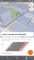
The app displays places where data can be added to OpenStreetMap through the app as quest pins on a map. Each of these quests can easily be solved by answering a simple question, like for example "Is this street lit?". The answers given are then processed and directly uploaded into the OSM database in the name of the user's OSM account.
So, unlike most other OSM editors, the actual data is not displayed directly on the map, no POIs can be added or edited directly and no geometry can be changed. Contribution with this app happens exclusively by answering these quests.
Missões
See the quests list for an overview which quests can be solved with this editor.
Additional Features
It is possible to add and contribute to OSM notes with this app. Notes phrased as questions (contain a question mark) are shown to all StreetComplete users, enabling them to add the requested information on-site. Users of this app can directly add photos to notes (since v4.0).
Albeit modification of geometry is in general not possible with this app, it is possible to split ways when the property that is being asked about in a quest does not span the entire highlighted section (since v14.0).
For certain more volatile properties of map features (such as opening hours), users are periodically asked again in certain intervals to verify if the input data is still correct, thus helping to keep the map data up to date (since v23.0). For shops in particular, users can directly specify what is there now in case the shop closed down (since v28.0).
Through contribution with this app, users are able to earn achievements (since v19.0) and look at their contribution statistics with the app. Earned achievements unlock certain links to be added to their link collection within the app. These links mostly serve to either introduce the user to OpenStreetMap or showcase an interesting OpenStreetMap-based project.
The app fully supports Android's night mode, including a dark theme for the displayed map (since v11.0).
After an area has been downloaded, the app is fully usable offline in that area, even after a restart of the app or device. The answers can be uploaded later and in case the data has changed in the meantime, there is smart automatic conflict resolution. (enhanced since v29.0 and again in since v32.0)
A team mode allows for "mapping parties" of up to 12 people to map the neighbourhood together at the same time (since v31.0)
FAQ
Veja a FAQ.
Contributing
You can help to translate the app via POEditor. This help is welcomed, translation is - as usual - part of creating the software where developers especially need help.
Suggestions, issue reports, feature requests can be made and other contributions be submitted on GitHub. Before proposing new quest types, please read the guidelines for new quests and see the quests list for an overview which quest types already exist.
Writing code improving StreetComplete and submitting pull requests is also welcomed - see "Contributing" file for more info.
The author of the app also accepts donations, see the project home on GitHub for more information.
Internals
The app uses Tangram-ES for displaying the map.
It directly uses the OpenStreetMap API (via Osmapi (Java)) to download the data and upload the answers. Up till before v26.0, the Overpass-API was used for download.
See also
- Vespucci - fully featured editor for Android with full and direct access to OSM data. But more complicated to use.
- GoMap!! - fully featured editor for iOS
- Summary of what needs to be done to have iOS port of StreetComplete
Weblinks
- StreetCompleteness - tool that analyze the completeness of StreetComplete quest for a given city.
