User:Eimai/Belgian Roads
Icon legenda
Vehicle types
Main classes
| Icon | Description |
|---|---|
| Pedestrians | |
| Bicycles | |
| Mopeds class A (mofa) | |
| Mopeds class B (moped) | |
| Mopeds class P (speed_pedelec) | |
| Horses | |
| Motorcycles | |
| Agricultural vehicles (vehicles for slow transport) | |
| Other motorized vehicles: motorcars, buses, goods vehicles, motorized vehicles with three and four wheels |
Restrictions
| Icon | Description |
|---|---|
| Always allowed | |
| Allowed if it's destination traffic | |
| Allowed if the vehicle doesn't have more than two wheels (voiturettes, trikes, quads, motorcycles with side-car, etc.) |
Highway types
Roads with restrictions
See the previous section to choose the highway=* tag value.
| Picture | Traffic Sign | Tags | Allowed Vehicles | Description |
|---|---|---|---|---|
|
|
|||
|
|
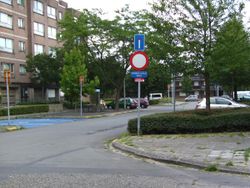
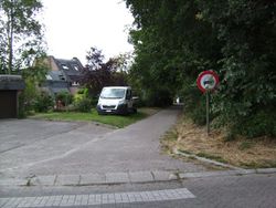
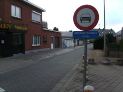
No entry for motor vehicles with more than 2 wheels (not just motorcars!) and motorcycles with sidecars
| ||
|
|
|||

|
|
Paths
| Picture | Traffic Sign | Tags | Allowed Vehicles | Description |
|---|---|---|---|---|
| none |
Normal path without any signs. Cars aren't able to drive there (too narrow, or there's a barrier preventing access). To distinguish between paved and unpaved paths, use surface=paved or surface=unpaved | |||
|
Path where no vehicles are allowed. | |||
|
No vehicles allowed, except bicycles. | ||||

|
No vehicles allowed, except bicycles and mopeds class A. | |||

|
Too narrow for cars. Horses aren't allowed. | |||

|
|
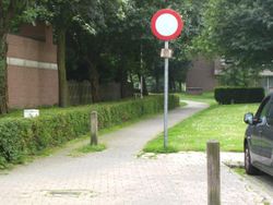
No entry for motor vehicles with more than 2 wheels and motorcycles. | ||

|
No entry for all motor vehicles. | |||

|
No entry for all motor vehicles and horses. | |||
|
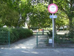
No entry for bicycles and mopeds (+ mofas and speed pedelecs) | |||
|
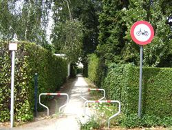
No entry for mopeds (+ mofas and speed pedelecs) | |||
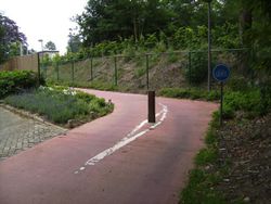
|
||||
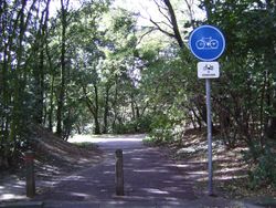
|
||||
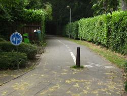
|
||||
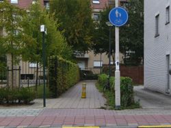
|
||||
Roads and paths signed with traffic sign F99a/F99b/F99c
|
Read me first | ||||
|---|---|---|---|---|
|
These signs are a special kind: they can be placed on roads and paths. The first thing you have to do then is decide whether you classify it as a path or a road. These signs allow motorized traffic like cars to parcels next to the road. Of course, the road should be able to be used like this. If the sign is on a one meter wide path you know that cars can't go there and it's clear that it's a path. If there are houses along the road, it's wide enough and there are no barriers you know it's a road. But there are many cases in between. As a first rule: if the width is less than needed to let a car pass, or when there are barriers blocking access to vehicles with the width of a car, then it's a path. In the other cases:
If you have for example sign F99a on a residential road and you can only enter the road with a car from one direction, then the classification becomes path after the last house. Roads are tagged with highway=unclassified for paved non-residential roads, highway=residential for paved residential roads and highway=track for unpaved roads. Paths are tagged with highway=path. Always add a traffic_sign=* tag with the correct traffic sign, an access tag for each symbol on the sign, and on roads an access=destination tag. Also add access=destination if you can access buildings from a path. Final note: you may always encounter a road where these rules can't be applied, in that case just do the logical thing. | ||||
|
Roads | ||||
| Picture | Traffic Sign | Tags | Allowed Vehicles | Description |
|
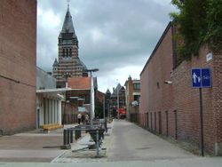
You can enter the road with a car to go to the buildings next to it (no barriers and it's wide enough), so it's not a path. | |||

|
|
Unpaved road reserved for agricultural vehicles, pedestrians, cyclists and horse drivers. | ||
|
Paths | ||||
| Picture | Traffic Sign | Tags | Allowed Vehicles | Description |
|
||||
|
||||
|
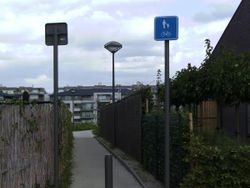
Road too small for a car. | ||||
|
Miscellaneous vehicle symbols | ||||
|
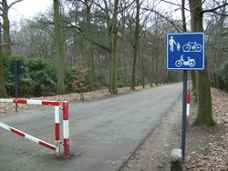
Traffic code allows that the signs for roads reserved for pedestrians, cyclists, horses and/or agricultural vehicles can be adapted to other vehicle types. Here are some examples: | ||||
|
Allows all mopeds as well. Barrier over the road so it's a path. | |||
Footpaths, cycleways and bridleways as part of a road
Mostly has to be written still... But if you're tagging them separately you can use the same tags as above. Otherwise use for example cycleway=track with cycleway:moped=no.
| Picture | Traffic Sign | Tags | Allowed Vehicles | Description |
|---|---|---|---|---|
|
Road: Pavement: |
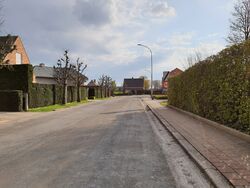
Road with a pavement and no cycleway, inside built-up area. | ||
|
Road: Pavement: |
Road with a pavement and no cycleway, outside built-up area. | |||

|
Road: Cycleway: Pavement: |
Road with cycleway (D7) and pavement, and maximum speed on the road is 50 km/h or lower. | ||

|
Road: Cycleway: Pavement: |
Road with cycleway (D7) and pavement, and maximum speed on the road is higher than 50 km/h. | ||

|
Road: Cycleway: |
Road with cycleway (D7) and no pavement or walkable shoulder, and maximum speed on the road is 50 km/h or lower. | ||

|
Road: Cycleway: |
Road with cycleway (D7) and no pavement or walkable shoulder, and maximum speed on the road is higher than 50 km/h. | ||
| Road:
Cycleway: Pavement: |
Road with cycleway (D7+M6) and pavement, and maximum speed on the road is 50 km/h or lower.
(M6 should only be used on roads where the speed limit is 50 km/h or lower, as higher speeds require mopeds to drive on the cycleway by default.) | |||
| Road:
Cycleway: Pavement: |
Road with cycleway (D7+M7) and pavement, and maximum speed on the road is 50 km/h or lower. | |||

|
Road:
Cycleway: Pavement: |
Road with cycleway (D7+M7) and pavement, and maximum speed on the road is higher than 50 km/h. | ||

|

|
Road:
Cycleway: Pavement: |
Road with cycleway (D7+M16) and pavement, and maximum speed on the road is 50 km/h or lower. | |
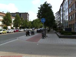
|
Road: Cycleway: Pavement: |
Road with segregated cycleway and pavement (D9), and maximum speed on the road is 50 km/h or lower. | ||

|
Road:
Cycleway: Pavement: |
Road with segregated cycleway and pavement (D9), and maximum speed on the road is higher than 50 km/h. | ||
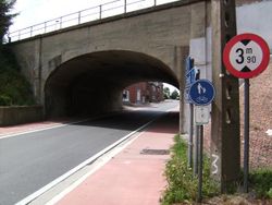
|
Road: Combined foot- and cycleway: |
Road with combined cycleway and pavement (D10). | ||

