JA:Hiking Map
英語版の記事の内容が分かる方は、翻訳の完成にご協力ください。このウィキの翻訳方法についての説明をお読みください。
現時点では、誰もこの記事の翻訳に取り組んでいないようですので、あなたが取り組めます。
このウィキページでは、 OSM のスリッピーマップレイヤーのための新しい機能アイデアを集めることを意図しています。Cycle Map に似ていますが、より登山者、ハイカー、放浪者、キャンパー、歩行者、乗馬、およびその他の郊外ユーザーに向いています。
アイデアと提案
- relief contour lines の表示
- 地図上に自動的に歩行距離をレンダリング
- 小道とトラックの様々なタイプのウェイは、未舗装路と舗装路を色を変えて強調表現します。
- 特に自然地物へ注目。
- 特に橋と階段に注目。
- (relations や highway=path でタグ付された)歩行ルートの色分け表現。
- マウンテン/アルペン ヒュッテ, 避難小屋, 丸太小屋, wilderness huts,などのアイコン表現。(参照提案: Proposed_features/Shelter, Proposed_features/Alpine_Hut)
- ビューポイントのアイコン表現。
- 水飲み場, トイレ, くずかご, など,その他のアイコン表現.
- よりよい精度のために同じ道のGPSデータを結合します。
- GPSログから詳細なトレイル情報ページやサイトにリンクします。
- トレイルの開始/終了地点を識別するフラグ(往復ルートにも対応)
- 駐車場の場所を表示する方法
一般的なレンダリングのヒント
トレイル
- in case of a relation:route the code of the path should be rendered in text, this code is normally in ref=*. When name=* is present it should be displayed as well. In case of lack of space we should discuss which one has priority.
- in case of simple way, highway=path or highway=track or highway=footway, not included in a relation:route we should display the ref and/or name of the way.
As of 2013-09-10:
- In WayMarked Trails: the route ref=* is rendered (I'm not sure about the name=*). In absence of route, the way name is rendered and the ref is not.
- In hikebikemap.: informations in relation:route are ignored. The way name=* is rendered and if not available the ref=*.
- In the default mapnik style, Cyclemap, maps.refuges, dianacht, 4umaps: informations in relation:route are ignored. The way name=* is rendered while ref=* is not.
Difficulty
The combination of sac_scale=* and trail_visibility=* should be rendered with the line style and color. Examples can be found in sac_scale#Rendering or osmc:symbol=*. It makes sense to use these tags on single ways. Does it make sense to apply them to relation:route?
As of 2013-09-10:
- maps.refuges: follows the indications of sac_scale#Rendering.
- WayMarked Trails: follows the indications of osmc:symbol=*.
- In 4umaps: the sac_scale=* is rendered in text together with mtb:scale=*.
- the default mapnik style, Cyclemap, dianacht: no indication of difficulty is rendered.
Groups of features
At high scales the name of groups of features should be rendered, specifically:
- mountain ranges
- valleys
- lakes groups
As of 2013-09-10: dianacht: renders mountain ranges with the Proposed relation: Region mountain_area.
地図の例
OpenHikingMap
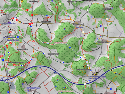
ここに私が取り組んでいる「ハイキングマップ」を示します。詳細は こちら を参照願います。
ハイキング・ライディング マップ
私は派生ハイキングマップ(ドイツ語)にも取り組んでいます。 というよりも、私は馬に乗ってマッピングをしています。いつの日か乗馬トレイルに最適な地図を作ることに取り組んでいます。しかし、ハイキングマップのための要件が非常に類似しているので、乗馬トレイルは、ハイキング目的にもかなうことができるはずです。
主要な要件:
- 等高線
- 山の陰影
- 小道やトラックのグレードの表現と強調
- あらゆる種類のランドマーク
- ハイキングルート
ハイキングマップでの私の最初の仕事はGarmin機器とOSM Composerのためのマップから始まりました。オープンなレイヤーマップのために、mapnikにマッチするスタイルを生成するために、私はコンポーザーを拡張しました。これは、正確で、陰影ついて、オンライントポマップとマッチする Garminマップが入手可能になるであろうということを意味しています。
基本的な設定:
- データベース PostGreSQL/PostGIS
- HikingBikingMapsのように等高線を表示する
- HikingBikingMapsのように山の陰影を表示する。しかし、修正されたgdal2tiles.pyによって、タイルを暗くし、オープンなレイヤー命名法の中でそれらを名付けます。
- ダウンロードされたOSMデータは OSM composer で処理される。
- ハイキングルートに評価とコメントを追加する。
- 不要なデータを削除する。
- Garmin TYP 定義にMapnik用のフォアグラウンドとバックグラウンドの2つのスタイルシートが OSMコンポーザーによって作成されます。
- migurskiが推奨する方式によって mapnik でレンダリングされました。
- 背景表現 (ほとんどのランドユース)
- 山の陰影は背景に表現
- 前景上に表現 (輪郭,ウェイ,ノード)
http://hiking.waymarkedtrails.org/
http://hiking.waymarkedtrails.org/
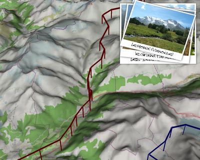
3D ハイキングマップ

(Google Earthのような)3Dハイキングマップは、インターネット接続がなくても、OpenSceneGraph (SRTM data) を生成します。 右の上のスクリーンショットは、非常に長いハイキング/マッピングパーティの企画 Via Alpina (2012夏) 用に作られたビデオトレイラーからの抜粋です。
関連ページ
- HikingBikingMaps
- WikiProject_Germany/Wanderwege-Netz
- WikiProject_Belgium/Walking_Routes
- WikiProject_Belgium/Conventions/Walking_Routes
- Proposed_features/Guidepost
- Freemap
- OSM Composer Garminデバイス用のハイキングマップ
- OpenAndroMaps アンドロイド機器向けのオフラインのハイキング/サイクリング地図です。
- トポマップ - ドイツ Garminデバイス向け
- OpenStreetMap カスタムレンダリング - OpenTrackMap Experience
- hikingbook.pl
- 世界一周ハイキング
- 80日間マッピングパーティ Via Alpina (Summer 2012)

