ES:Tag:railway=station
| Descripción |
|---|
| Una estación de tren. |
| Representación en OSM Carto |
| Grupo: Ferrocarriles |
| Usado en estos elementos |
| Combinaciones útiles |
|
| Estado: de facto |
| Herramientas para esta etiqueta |
Si comprendes el artículo original en inglés, por favor, ayuda a completar esta traducción al español. Lee las instrucciones sobre cómo traducir este wiki.
Parece que nadie está trabajando en la traducción en este momento. Anímate y colabora en la tarea de traducción.
- Artículo principal: Railway Stations
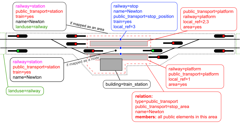
Railway stations (including main line, light rail, subway, etc.) are places where customers can access railway services or where goods are loaded and unloaded. railway=station should be applied to an area covering the whole station, or preliminary on a node placed at the center of the station area, from the passengers' point of view (i.e. near platforms).
In addition, you can use the public transport tag public_transport=station.
Distinction Between Halt and Station
The distinction between railway=halt and railway=station might differ from country to country. A halt is usually smaller than a station.
- In German-speaking countries, stations without points ("switches") where only passenger trains stop are tagged as halt. For more information see the german page.
How to map
Railway stations are mapped as an area covering the whole station (tracks, buildings, platforms, etc.) or a node at the center of the station from passengers' point of view. This is usually an unconnected node at the platform area. This node does not have to be part of a railway track.
If you want to map the station as an area, please consider that different people describe the station area differently. While passengers only have the area around the station building and the platforms in mind, railway staff and railway enthusiasts think of the whole railway area which begins at the entry signal at one side and ends at the entry signals at the other side.
While infrastructural areas can be added to a landuse area and tagged landuse=railway, this is already implied by railway=station. Some people connect a station node and the landuse area using an operating site relation, but this is likely not needed as there is already a spatial connection.
Where a mainline station and metro station (or other railway like station) share the same station building, consider if they should be modelled as separate stations or as a single station. The associated Wikipedia article for the facilities might assist with the decision. If the facilities are run by separate organisations (for example a heritage station next to a mainline station) then it is probably better to map them using two separate railway=station tags.
Following tags are commonly used on railway stations:
- uic_ref=number which is a unique code for railway stations as registered with the UIC
- name=*
- operator=*
- platforms=*
- station=*
- subway=*
note
The area a passenger has in mind might not be mapped directly. Data users can create this area by calculating a convex hull around the stop area relation like OpenBusMap does.
A Simple Railway Station
Things to avoid
- There should only be a single railway=station object for each station.
- Bus stops do not use this tag, see Public_transport.
- The tag railway=tram_stop for tram stops is still in use. Please add it to new tram stops and do not remove it on existing tram stops. See Public_transport.
- Don't forget to add subway=yes or station=subway if it is a subway station. For light rail, use station=light_rail
- Using the word "station" in the name=* if it is not part of the name printed on signs at the station, i.e. avoid name=Station Newton
- Don't use abbrevations even if the railway company always use them. Use short_name=* in addition.
- If the official name in documents differs from the name printed on signs at the station, use official_name=*.
- Disused stations should be tagged historic:railway=station if there is still a building or platform, or historic:railway=station_site if not. See Railway stations.
See also
- public_transport=station - tagging scheme which covers infrastructure use
- railway=halt - to tag a smaller station.
- building=train_station - useful to map the station building itself. note, that sometimes railway terminal can have name, different from name of railway station - be accurate in such cases, when adding names tags. Name of railway station should be added to railway=station object, name of railway terminal - to building=train_station object.
- railway=subway_entrance - to go into a subway station.
- railway=platform and public_transport=platform - to map individual platforms in the station.
- local_ref=* Used on some bus stops, e.g. NaPTAN/Tag_mappings
- OpenRailwayMap and its feature-rich tagging scheme
- OpenStationMap map showing the levels of a station
Example
See Karlsruhe Central Station for reference. The Gare du Nord, in Paris also applies this model (with references to various networks for long distance lines, high-speed lines, regional commuter trains and subways).
| ||||||||||||||||||||||||||||||||||||||||||||||||||

