Lifecycle prefix

Note that OpenStreetMap documents current state. Not existing objects are only mapped when risk of accidental remapping is high and with some limited and controversial marking of mapping planned construction.
But if for example one of buildings visible here would be demolished it would likely make sense to keep demolished:building=* geometry, as long as it is visible on standard aerial imagery for this area.
The lifecycle/status namespace prefix can be used to tag objects with a status such as proposed, planned, construction, disused, abandoned, demolished, historic. See also Comparison of life cycle concepts.
By using this key prefix it is ensured that current or legacy applications are not confused by objects which do not exist or are not fully functional and only software aware of this tagging concept will evaluate those.
See also date namespace for a related proposal to include dates for historic tags, for example name:-1965=Kings Place. The two possibilities can be combined to some extent.
No longer existing objects may be marked as existing in other sources. For example demolished building may be visible on aerial images, official maps may include now dried up wetland etc. Using lifecycle prefixes it is possible to clearly mark that specific object must not be remapped without proper verification. Once there is no real risk of remapping them by person thinking that this objects are still existing such elements should be deleted from OSM.
Historic objects with no relevance to current state of an object generally do not belong in OpenStreetMap.
Historic data can be added to Open Historical Map.
How to tag
Add a namespace prefix (for example disused:*=*) to all keys which are no longer relevant to the current state of an object. You should treat all the tags on an object as a set of facts about the object, and prefix the keys of those facts which are no longer true as a result of the disuse. For example, a concrete parking area which is no longer used for parking cars but which still carries a name sign might be tagged as
which makes it unavailable to programs which search parking, and unlikely to be displayed as parking in any default rendering. The name is still relevant, and will still be searchable. If the area is opened up again, it's a simple matter to undo the prefixing.
How to reference in wiki
Following is the recommended way to reference disused and other prefixes in {{Tag}} template:
Common prefixes
Stages of birth
- proposed:*=*
- Planned, with a high likelihood of being constructed
- See also scheme proposed=* in combination with highway=proposed, railway=proposed, aeroway=proposed, etc.
- usage: ~96,375 elements (nodes, ways and relations) include the prefix (as of 2024-12)
- planned:*=*
- Planned, with a high likelihood of being constructed (possible duplicate of proposed:*=*)
- Some consider planned:*=* to be stricter than proposed:*=* (i.e., a planned feature that is approved and funded).
- usage: ~7,791 (as of 2024-12)
- construction:*=*
- Being constructed at this time (or construction work for maintenance or modification is performed)
- See also scheme construction=* in combination with building=construction, highway=construction, landuse=construction, railway=construction, etc.
- usage: ~90,190 (as of 2024-12)
Stages of decay
- disused:*=*
- Not currently in use, but could be reinstated easily
- For physically prominent objects (e.g. buildings, towers or quarries), disused=yes is used more often[1].
- Railways: railway=disused is still used in addition to the lifecycle prefix, as it pre-dates the introduction of prefixes.[2]
- usage: ~399,374 (as of 2024-12)
- abandoned:*=*
- Still visible but fallen into serious disrepair and which could only be put back into operation with considerable effort
- For physical objects (e.g. buildings, towers or quarries), abandoned=yes is used more often[3].
- Railways: railway=abandoned for partially dismantled tracks is still used in addition to the lifecycle prefix, which pre-dates prefix introduction.[2]
- usage: ~478,994 (as of 2024-12)
- ruins:*=*
- Only ruins are remaining
- usage: ~9,694 (as of 2024-12)
The following four tags are available to reduce the possibility of a mapper remapping the feature from existing available sources used to edit OSM, e.g. satellite or aerial imagery, that shows the old state of the feature. Once the OSM available sources do not show the feature, the feature can safely be removed from OSM. Renderers cannot rely on OSM preserving physically vanished history.
- demolished:*=*
- Not existing anymore because of active removal
- May have been used for features that are almost but not completely invisible
- usage: ~156,200 (as of 2024-12)
- removed:*=*
- Not existing anymore because of active removal (possible duplicate of demolished:*=*)
- usage: ~69,834 (as of 2024-12)
- razed:*=*
- Not existing anymore because of active removal (duplicate of removed:*=*, possible duplicate of demolished:*=*)
- Railways: railway=razed for fully dismantled tracks and trackbed (overbuilt state) is still used in addition to the lifecycle prefix, because it pre-dates prefix introduction.[2]
- usage: ~81,113 (as of 2024-12)
- destroyed:*=*
- Destroyed by an event other than intentional demolition
- usage: ~50,136 (as of 2024-12)
Repurpose
- was:*=*
- Not what it used to be
- usage: ~136,123 (as of 2024-12)
- For shops or businesses, disused:* and was:* tags are identical, it is mostly a matter of personal preference and both will achieve the same result, i.e. the place will no longer appear on the map while the information would be easily visible to anyone editing the map, preventing the accidental re-addition of those tags.
Less common prefixes
Stages of decay
- closed:*=*
- Not currently in use, but could be reinstated easily (duplicate of disused:*=*)
- Used for closed businesses and services (e.g. shops, restaurants, offices, banks).
- usage: ~1650 (as of 2025-01)
- no:*=*
- Does not currently exist.
- usage: ~760 (as of 2023-03)
Repurpose
- historic:*=*
- Misleading because of inconsistent use – not recommended for lifecycle tagging
- While someone tried to establish the concept of "a previously valid characteristic for an object that has different properties today", this never actually got accepted and this prefix is used for various other things in an inconsistent manner. Most used as historic:civilization=*, historic:period=*, historic:railway=* and historic:<some railway property>, further as historic:year:* (similar to the date namespace) and some other ways.
- usage: 92,700 (as of 2021-04)
Other
- emergency:*=*
- Used on multi-purpose facilities to reflect a temporary, secondary function for exigencies
- usage: ~15,900 (as of 2021-04)
- not:*=*
- Used for prevention of confusion
Examples
| Image | Tagging | Description |
|---|---|---|

|
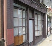
disused:shop=yes | A closed-down shop of some sort. If the type of shop it used to be is known, substitute the appropriate value from shop=* for yes. |

|
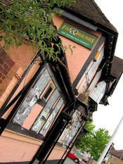
disused:amenity=pub disused:operator=The Oxford Pub Company name=Fox & Hounds |
Boarded-up disused public house. It no longer has an operator as such - no beer is sold - but the name is still useful for navigation. |

|
railway=disused disused:railway=rail |
Historic railway line. Tracks not degraded but overgrown. |

|
electrified=no construction:electrified=contact_line |
Railway line with electrification works in progress. |

|
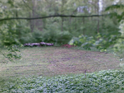
disused:leisure=pitch | Disused pitch, now somewhat overgrown. |

|
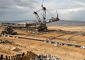
objects that were there before open pit mine are not tagged | Open pit mine. Forest that used to be here must not be tagged in any way, as no identifiable trace of it remains and is unlikely to be mistakenly mapped again. Only in cases where mappers are likely to reintroduce old objects (pit mine is new and not visible in some still used aerial images) it can be mapped. |

|
railway is not tagged | Place where railway existed in the past. It must not be tagged in any way, as no identifiable trace of it remains and is unlikely to be mistakenly mapped again. Only in cases where mappers are likely to reintroduce old objects (railway was dismantled recently and is still visible in some used aerial images) it can be mapped. |

|
canal/moat is not tagged | Place where waterway existed in the past. It must not be tagged in any way, as no identifiable trace of it remains and is unlikely to be mistakenly mapped again. Only in cases where mappers are likely to reintroduce old objects it can be mapped (recent removal, and likely to remapped from aerial image). |
See also
- intermittent=* – Used to indicate whether or not a waterway or water body does not permanently contain water
- start_date=* – date on which a feature opened or construction of the feature finished
- construction_date=* - date on which construction of the feature has been finished
- opening_date=* – date on which a feature is expected to be opened
- end_date=* – date on which a feature is planned to go out of use, or when it went out of service
- Proposed features/temporary
- Proposed features/temporary (conditional)
- Demolished Railway – tagging of demolished railways
- Open Historical Map
References
- ↑ see for example quarries: disused:landuse=quarry is used 706 times while 4627 landuse=quarry have disused=yes
- ↑ 2.0 2.1 2.2 Using railway=disused;abandoned;razed heterogenified the value set of key railway by mixing track class with lifecycle class values. With this legacy lifecycle representation the track class information usually expressed in railway=* is lost (practical consequence e.g.: a data user cannot differentiate between abandoned tram or rail tracks). As a long-term change it is recommended to support and evaluate the lifecycle prefix variants. The presence of both tagging variants on data objects is still advocated by wiki, but this may change in the future.
- ↑ see for example quarries: abandoned:landuse=quarry is used 669 times while 2364 landuse=quarry have abandoned=yes