Osmose/issues
If you know about the current state of affairs, please help keep everyone informed by updating this information. (Discussion)
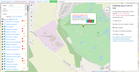
Since February 2020, the documentation of issues detected by Osmose is shown directly in the interface (frontend)
An information panel is available on the right. It can be open and close with "i" button.
It contents documentation about current selected marker the section are Titles, Details, Correction aids, pitfalls to Avoid, source code, etc. This content is included in the source code of the analyses. You can contribute to the improvement of the documentation by proposing changes to the source on Github. Online on the Github website just use the pencil icon and let Github guide you to make a change request (pull request).
Osmose tool is mainly developed by french people, and we aim to add more languages. To make Osmose a real multi-lingual tool, we need your help to improve current translations, and add new translations. Translation is done on Transifex. You can create a new language directly on Transifex. For new countries, we can be contacted through a direct email to osmose-contact@openstreetmap.fr.
List of issues detected by Osmose and their remedies ...
Structure
| Item | Help | Example |
|---|---|---|
overlapping building |
Details
In France, probably a building imported from *cadastre without the controls needed. Error is frequent on areas where lots of building are drawn manually, such as the HOT activations.
Fix
|
|
split building |
Details
Fix
|
|
duplicated node
|
Details
A path passes several times by the same node. Fix There are several types of issues:
Traps
These errors require a good command of your editing tool. Some corrections are not necessarily intuitive.
|
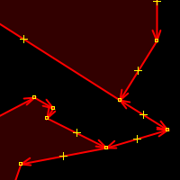 Double polygon connected by a string to remove |
invalid polygon
|
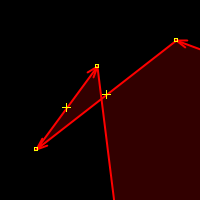
Details The polygon intersects itself. The marker points directly to the error area of the crossing.
Fix Find where the polygon intersects itself (ie it forms an '8 ') and correct geometry for a single loop (a '0') or by removing nodes or changing the order of these nodes, by adding new nodes or by creating multiple polygons.
Traps
Make sure the nodes to move do not belong to other way.
|
|
reverse roundabout
|
Details The circulation of the roundabout is draw clockwise, but in countries where they drive on the right the sense of roundabouts is counterclockwise, and vice versa for the other countries.
Fix Traps
Make sure that it is a roundabout (for example, no a side way in oposite direction around a square or a central roundabout, or driveways separated by traffic islands at an intersection without cross).
|
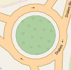 Clockwise rotation. |
boundary intersect
|
Details
Borders crossing. Fix
Check the type of border and keep the best or merged. Traps
The borders are part of relationships, they normally form loops.
|
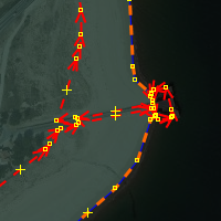 Tow definitions of the same border |
objects overlap
|
Details Objects that can not be overlapped in the same location.
Fix Move an object or check the tags.
Traps
|
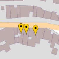 Intersection lane / building. |
orphan nodes
|
Details
Concentration of nodes without tag and not part of a way. Fix
Find the origin of these nodes. Probably in trouble in import. Contact the contributor submiting the nodes.
|
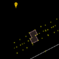 Group of orphan nodes. |
sudden highway type change
|
Details A way connects directly to the street classification much smaller.
Fix Review the classification of streets.
|
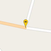 Secondary connecting directly to the residentials. |
unclosed area
|
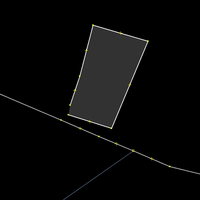
Details
a way has the tag area=yes, but is not closed. Fix
|
|
bad *_link highway
|
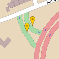
Details
Fix |
 highway=trunk_link linking highway=primary. |
broken highway continuity
|
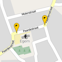
Details Check the continuity of way types highway=*. The classification of a highway should normally be consistent along the entire path. For example a highway=tertiary should remain highway=tertiary until it intersects with a road of higher classification
Fix Making continuous classification.
|
 highway=secondary becoming a local residential. |
missing tag or role
|
Details An objet without relevant tag (no other tag source=*, created_by=* or note:qadastre)) or a relation member without role.
Fix Add tags or role.
Traps
The object is sometimes duplicate.
|
|
surface intersection
|
Details Surfaces similar (waterway=*, natural=* and landuse=*) are superimposed.
Fix |
|
big relation
|
Details
A relation whose members should be close is geographically spread. Traps
|
|
multipolygon
|
Details
Fix |
|
double cycleway
|
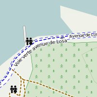
Details Fix
|
 Double mapping of the bike lane. |
approximate way
|
Details Way draw seems to be done crudely, there is a discrepancy between the drawing and the real way especially in the curve. Use Bing or Mapbox imagerie
Fix After checking (orthophotos), add a node or move existing nodes.
Traps
On service ways, train stations, train workshops that may be either a false positive
|
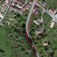 railway=rail way crudely drawn. |
1-member relation
|
Details
The relation only contains one member Fix
Check if no member is missing, check the history, check if there is another similar relation with more members. A one-member relation may sometimes be justified. Traps
Do not remove a relation without understanding why it is there.
|
|
not-connected highway/cycleway
|
Details The end of the way is not connected to another way.
Fix After checking, connect to another highway.
|
|
waterway
|
Details
Fix
|
|
far from water
|
||
duplicate geometry
|
Details
Fix |
|
one-node way
|
||
objects intersection
|
Details
Fix |
|
public transport
|
Details
Fix |
|
almost junction
|
||
enforcement
|
||
related objects
|
||
indoor
|
||
building landuse
|
Missing tags
| Item | Help | Example |
|---|---|---|
junction=roundabout
|
Details
This looks like a roundabout, but the tag junction=roundabout is not present. See Roundabout for more info. Fix
If it is really a roundabout, add the tag junction=roundabout, verify that the path is in the counter-clockwise when driving side is on right, and remove the tag oneway=yes if present. Traps
Ensure that it is a roundabout, using satellite imagery or a local survey.
|
|
elevation
|
Details
Some elements, including the peak (natural=peak) and mountain_pass (mountain_pass=yes), has an evelation. This is shown in OSM with tag ele=* in meters. Fix
Complete the tag ele=* missing.
|
|
oneway
|
Details
Fix Traps |
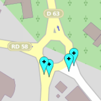 Lack oneway to access roundabout. |
source
|
Details
An administrative boundary does not contain tag source=* sourcing the origin. Fix
If the limit comes from the French Cadastre, add the appropriate source=*.
|
|
street numbers
|
Details
Fix No detailed fix instructions.
Traps
'False positives' Class 14 and Class 15 Marker using 'addr:inclusion=*'. (Corrected 10/2016)
|
|
highway
|
Details The way seems to be a highway=*.
Fix Add the tag highway=*.
Traps
Check that it is a highway=* and it is not already mapped.
|
|
highway crossing
|
Details A very close node already has the tag crossing=traffic_signals.
Fix It very likely that the traffic signals on the hub are inconsistent with each other, see also highway=traffic_signals.
|
|
pharmacy
|
Details
All French pharmacies sell prescription by a doctor. It is therefore added as a tag dispensing=yes in addition to amenity=pharmacy. Fix
Add tag dispensing=yes. Traps
Chemist shot ("parapharmacie" in French) do not fall into this classification. They do not have a specific tag for the moment.
|
|
missing object kind
|
Details The object is missing any tag which defines what kind of feature this is
Fix Add a "top level" defining tag to state what kind of thing this is.
|
|
indoor
|
Details
Fix |
|
access
|
Details
"Inconsistent Access" : Inconsistent motor_vehicle values ('destination'!=)
|
|
public_transport route
|
Details
Fix
|
|
zone:maxspeed
|
Details
Fix |
|
railways
|
Bad tag
| Item | Help | Example |
|---|---|---|
highway roundabout
|
Details
Fix |
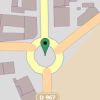 level highway should be secondary. |
bad source tag
|
Details
The source tag is incorrect. For example, for an object based on the cadastre, the year is YYYY instead of being properly initialized. Or the source is still "Cartographes Associés", which is an imprecise and dubious source or an illegal source as "Google" or IGN. Fix
Correct the source and use the register for the position of the object if necessary. If the source is illegal promptly notify the contributor to remove contributions.
|
|
tagwatch cleaner
|
Details Varied, simple and frequent errors, the list is available here.
Fix Succinct indications of the error are given in the tooltip and com from the wiki.
|
|
wikipedia
|
Details
Fix Replace the faulty value by the value displayed at the top of the article on Wikipedia, preceded by the language code and the separator ':' (in the absence of linguistic code, the item will be searched by default on the English Wikipedia, but it is advisable in this case to explicitly indicate thelLingusitique code "en" if the article mentioned is English, the language codes supported are those editions of Wikipedia in some cases they are different from the standard language codes BCP47 used as suffixes in other key OSM as "name:[LANG]=*"). A correction is suggested in the bubble issue.
|
|
multiple tags
|
Details This item includes lot of small validations, see details in the popup.
Fix |
|
saint hyphen
|
Details
In France the rule is that a hyphen is used when we refer to a saint (or a holy thing). Fix
Add a hyphen. Traps
This rule does not apply in particular to Belgium.
|
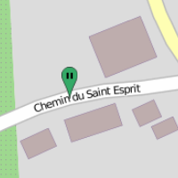 Name should be the Saint-Esprit. |
incorrect tag
|
Details
The tag of an object contains a value that does not consist of all lowercase letters or digits. Fix
Check the tag value, and translate if necessary. Traps
It's possible that the tag contains a name that should be moved onto name=*.
|
|
bad tag key
|
Details The key of tag contains characters not recommended. The key is composed of alphanumeric characters: 0-9, az (preferably small), separator '_' or ':'
Fix Check the key tag, and correct.
Traps
There certainly false positives.
|
|
similar values
|
Details The tag contains two values (separated by ';') which are very similar
Fix Delete one appropriate value
Traps
In some case all values maybe be required
|
|
multiple values
|
Details
The tag contains multiple values Fix
Check the accuracy of the values, if necessary, delete the obsolete values Traps
Double maxspeed according to vehicles
|
|
swimming pool
|
Details When importing layer of water of *cadastre, the tag water pools have not been corrected.
Fix Change tags natural=water in leisure=swimming_pool + access=private for a private pool or amenity=swimming_pool for a public pool. There is also other kinds of smal water place like landuse=reservoir, landuse=basin or landuse=pond.
|
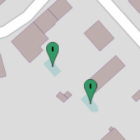 Wrong tag for private swimming pool. |
date
|
Details
The date entered is not in expected format as definited here Key:start_date
|
|
numeric value
|
Details The tag expects a numeric value. Decimals are set with one point and not a comma
Fix Change to numeric value and/or the comma to point
|
|
phone number
|
Details
Fix |
|
URL
|
Details
Fix |
|
small land use
|
||
note
|
Details
Analyzes the tag note=* with French and English keywords. Fix
Use a more appropriate tag as description=*, opening_hours=* or add "FIXME" in the note so it can be found more easily. Traps
The analyse can provide crazy result
|
|
tree
|
Details Fix
Put the right data in the correct tag (in this case species) Traps
Trap specify the language for the tag "species" (species:en=oak)
|
|
brand in name
|
||
typo in tag
|
Details
The tag is misspelled. Detection is based on statistics. Traps
Check that the correction does not change the intent of the tag.
|
|
incorrect "lanes"
|
Details There is an incohorence with lanes=* tags:
Fix |
|
parking lane
|
Details
Fix |
|
relation role
|
Details
The role is not a keyword as expected. Fix
Determine the right role, possibly set the value of the role in a tag.
|
|
relation type=restriction
|
Details Incoherence in a Restriction type of relation.
Fix |
|
postcode
|
Details
Check postcode as decribed here.
|
|
area
|
Details
Fix |
|
noexit
|
Details
Fix |
|
access
|
Details access=yes mean wide open to all transport mode, look at [2]
Fix |
|
recycling container
|
Details
Fix |
|
route access mismatch
|
Details
Fix |
|
opening hours
|
Details
Fix |
|
VAT
|
||
conditional restriction
|
||
sideway
|
Tags to remove
| Item | Help | Example |
|---|---|---|
disused
|
Details The tag or combination key/value is no longer used. List of deprecated features comes from Deprecated_features
Fix Succinct indications of the issue are given in the popup.
|
|
on junction=roundabout
|
Details The tags oneway=* and ref=* are not necessary on the roundabouts. The tag name=* must be present if this is the name of the roundabout and not a road connected, same thing for ref=*.
Fix Remove unnecessary tags.
|
|
incompatible tags
|
Details The object contains two incompatible tags
Fix Remove the tag in too
Traps
Sometimes the object needs both tags
|
|
ref in name
|
Details Fix
|
|
fixme import
|
Details Seamark was imported but need manual review seamark:fixme=*
Fix Move the seamark on real position and remove the tag seamark:fixme=*
|
|
fixme review
|
Details Need fix
Fix This is a catchall category for various errors. If highway=road has been used, choose a correct value, such as highway=unclassified ("Minor Road" in iD).
|
|
construction
|
Details The tag building is perhaps more necessary. The tag opening_date=*, check_date=*, open_date=*, construction:date=*, temporary:date_on=*, date_on=* are not present and the object is in construction for more than two years or dates is exceeded.
Fix |
|
duplicate object
|
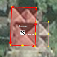
Details Object tagged twice as node, way or relation.
Fix An entity must be present only once, remove one and eventually merge the tags.
|
|
unwanted tag on node
|
Details
Way node tagged like way. Probably due to a wrong selection when editing, nodes in the way have the same tags that way. Fix
Check and remove tag from node.
|
|
bad usage
|
Details
designation=* is a United Kingdom-specific tag, highway=emergency_access_point does not exist in France. Fix
Translate it to another tag or remove it.
|
|
incorrect layer
|
Details
Fix |
|
duplicate wikipedia
|
Tags name
| Item | Help | Example |
|---|---|---|
orthograph
|
Details Several types of spelling issues are detected
Fix Correct the error.
|
|
way type
|
Details The kind of street in the tag name=* is not written correctly : (Street, Boulevard...
Fix Correct fix the broken type, accents, remove abbreviations, ...
|
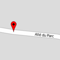 The name should be Allée or not Allé. |
two names
|
Details
Le tag name=* contains two street names, separated by a semicolon, a "/" or a "\". This issue was probably produced by the fusion of two way and the concatenation of the names of streets. Fix
Traps
Some streets have not the same names on the each side, especially if the houses by both sides are on different city. In this case, you can use the tag name:left=* and name:right=*.
|
|
toponymy
|
Details
Apply of charte de toponymie de l'IGN (French geographic name conventions)
|
|
potential misspelling
|
Details
A street "sounds" like a street already known but is not spelled on the same way. Fix After you have checked that it was a mistake, change the name.
Traps |
|
local language
|
Details
Fix |
|
invalid character
|
Details
Fix |
|
similar name
|
Details
Fix |
Administrative
| Item | Help | Example |
|---|---|---|
open polygon
|
Details A relation that should be a closed polygon is not closed. Issues are reported at each end of isolated polygon
Fix |
|
duplicated way
|
Details
In a relation, a way should be present only once. Fix
Most often, this is an user issue that add several times the same way. The editor JOSM can easily visualize the relationships and see duplicates (in color). Traps
|
|
place without name
|
Details Fix
For cities/towns, it is sometimes possible to find the name of the village based on the boundary relationship and/or if the INSEE ref code if is entered. Traps
The tag place=* is often misused (see FR:Key:place), it should not be associated with tags such as amenity, highway. .. if the case, the tag place=* can be removed.
|
|
INSEE code
|
Details Check of *tags 'ref: INSEE' and 'name' are consistent with the COG database [3]
Fix Correct value INSEE or name as appropriate.
Traps
The names on nodes place=* may differ from the COG of INSEE, especially for merged city (clusters of many nodes 'place'). We must then move the tag 'ref: INSEE' from node to the boundary relation. It also happens in several occasions that local authorities are at odds with INSEE. In this case, that's always been a priority for the field on OSM.
|
|
erroneous boundary
|
Details Relation of admin_level=8.
Fix |
To map
| Item | Help | Example |
|---|---|---|
geodesic building
|
Details
A survey point has a name that underlying meaning is located on a building (belltower, water tower, tower), but the node is not inside a building polygon (building=*). Fix
If the building footprint is present but is misplaced because of a shift in the source data (cadastre, orthophotograhies), replace the layout of buildings to correct this issue. Otherwise, the building must be draw. Traps
Do not move the geodetic point, because it a reference (see The page describing the import of these geodetic markers ) ! It could be that all the surrounding buildings are shifted.
|
|
building shape
|
Details The form of a building is characteristic and as such would be tagged.
Fix An aerial view can help determine the use of the building.
|
|
bridge to tag
|
Details Fix
See the possible types of bridges bridge=*.
|
|
admin boundary
|
||
power lines
|
Details This analysis mainly verifies the continuity of powerlines
Fix Several types of issues are generated:
|
|
post office
|
Details
This analysis tests whether the reference of the post office is there. See also item 8020 and 8021. Fix
Make merge of data from the postal database via the item=8021.
|
|
post box
|
||
school, not integrated
|
Details This analysis allows to check whether the reference of the school is present. See also 8030 and 8031 item.
Fix Make merge of data from the ministry data via the item=8021.
|
|
monument
|
Details
This analysis allows to check whether the reference of historical monument inscribed with the specified operator heritage:operator=mhs also contains the registration number in the inventory. See also 8010 and 8011 item. Fix
Find the entry in the inventory of the monument and add the reference number. Check the value and format of the inventory number. Or make a data mergia via the 8011 item.
|
|
node on ways
|
Details Crossing for which it lacks the road or railway.
Fix Map the missing part. The node must be common to rail and road.
|
|
train station
|
Details
Pas de gare avec le tag uic_ref=* trouvé. Voir également l'item 8050. Fix
Make merge of data via the item=8051.
|
|
TMC
|
Details TMC data refers to a not found element of the road network.
Fix Add element.
Traps
TMC data may be wrong or poorly located.
|
|
relation type=boundary
|
Details Missing element in administrative relation Relation:boundary.
Fix |
|
tunnel/bridge
|
Details
Missing maxheight=* or maxheight: * for a tunnel or a way under a bridge.
|
|
pharmacy, not integrated
|
||
postal code, not integrated
|
||
road
|
Details
Fix |
|
power substation
|
||
hospital
|
Details
Fix |
|
medical lab
|
Details
Fix |
|
gas station, ref not integrated
|
Integration
| Item | Help | Example |
|---|---|---|
monument, museum
|
Details See also items 7080 and 8011.
Fix See Proposed features/heritage. Add a node or proposed to integrate tags something already existing.
Traps
Carefully check the contents of the proposed tag, it can hold values curious or unsuitable. Correctly locate the monument. The marker can be a very rough position, located as close to the town. Don't overide tags of UNESCO World Heritage.
|
|
monument, museum, could be integrated
|
Details See also 7080 et 8010.
Fix |
|
monument, museum, need update
|
||
post office
|
Details
Post Office of "La Poste". See also item 7050. Fix
Add new items or merge them with existing, see also item 8021. Traps
Check the location which was made by address geolocation.
|
|
post office, could be integrated
|
Details
See also items 7050 and 8020.
|
|
post office, need update
|
||
post box
|
||
post box, could be integrated
|
||
school
|
Details Location of educational institutions. See also item 7070.
Fix Add new items or merge them with existing systems see 8031.
Traps
Check the location. Warning data from the Ministry may have several schools following levels for a single physical school.
|
|
school, could be integrated
|
Details See also item 7070 and 8030.
Fix Traps
Check that it is right school.
|
|
school, need update
|
Details
Fix |
|
public transport
|
Details
Fix Add new points or merge existing. See also item 8041.
Traps
Check the location.
|
|
public transport, need update
|
Details
Fix |
|
train station
|
Details
Train station of French RFN network. Fix
Add new points or merge existing. See also item 8051. Traps
Check the location.
|
|
train station, could be integrated
|
Details
See also item 8051.
|
|
level crossing
|
Details
Level crossing from the French railway RFF network, for cars or pedestrians. Fix
Add new points or merge existing. Traps
Check the location.
|
|
geodesic point
|
Details WikiProject_France/Repères_Géodésiques French survey point imported in OSM but not found.
Fix Restore node or relation.
Traps
Osmosis offers reimport the remaining sites as point, but there is a relation. Must be converted manually to keep the tags and put survey point in relation.
|
|
postal address
|
Details Address an OpenData data set was not found. Only the position and street numbers are checked.
Fix Add or move a number, check the field.
Traps
Attention to the data freshness.
|
|
fire hydrant
|
||
fire hydrant, could be integrated
|
||
place of worship
|
||
church
|
||
public service
|
Details French public service not found nearby. Uses data from service-public.fr.
Fix Locate the placeand add the property or merge the data.
Traps
The location can be quite rough.
|
|
recycling
|
Details Recycling point amenity=recycling not found nearby.
Fix |
|
recycling, could be integrated
|
Details
Fix |
|
recycling, need update
|
Details
Fix |
|
parking
|
Details Parking amenity=recycling not found nearby.
Fix |
|
parking, could be integrated
|
Details See also item 8130.
Fix |
|
parking, need update
|
Details
Fix |
|
accommodation
|
Details Accommodation not found nearby.
Fix |
|
cycle parking
|
Details Bicycle parking amenity=bicycle parking not found nearby.
Fix |
|
transport sharing
|
Details Bicycle sharing service amenity=bicycle rental not found nearby.
Fix |
|
transport sharing, could be integrated
|
Details
Fix |
|
transport sharing, need update
|
Details
Fix |
|
sport
|
Details Sport spot not found nearby.
Fix |
|
toilets
|
Details
Fix |
|
toilets, need update
|
||
police
|
Details
Fix |
|
police, could be integrated
|
||
police, need update
|
||
gas station
|
||
gas station, could be integrated
|
||
gas station, need update
|
||
pharmacy
|
||
pharmacy, could be integrated
|
||
pharmacy, need update
|
||
postal code, could be integrated
|
||
library
|
||
restaurant
|
Details
Fix |
|
winery
|
||
geodesic
|
Details
Fix |
|
power plant
|
||
power substation
|
Details
Fix |
|
power substation, could be integrated
|
Details
Fix |
|
power substation, need update
|
||
power support
|
||
traffic signs
|
Details
Fix |
|
shop
|
||
traffic sign limitation
|
Details
Fix |
|
hospital
|
Details
Fix |
|
hospital, could be integrated
|
Details
Fix |
|
social facility
|
Details
Fix |
|
social facility, could be integrated
|
Details
Fix |
|
medical lab
|
Details
Fix |
|
medical lab, could be integrated
|
Details
Fix |
|
street objects
|
Details
Fix |
|
defibrillator
|
Details
Fix |
|
wastewater plant
|
||
wastewater plant, could be integrated
|
||
wastewater plant, need update
|
||
radio support
|
Details
Fix |
|
radio support, could be integrated
|
Details
Fix |
|
radio support, need update
|
Details
Fix |
|
charging station
|
||
charging station, could be integrated
|
||
charging station, need update
|
||
tourism
|
||
milestone
|
||
milestone, could be integrated
|
||
viewpoint
|
||
picnic
|
||
bicycle infrastructure
|
||
cemetery
|
||
man made
|
||
water infrastructure
|
||
water
|
||
fire station
|
||
natural
|
JOSM validator
| Item | Help | Example |
|---|---|---|
addresses
|
Details
Fix |
|
combinations
|
Details
Fix |
|
deprecated
|
Details
Fix |
|
geometry
|
Details
Fix |
|
highway
|
Details
Fix |
|
multiple
|
Details
Fix |
|
numeric
|
Details
Fix |
|
relation
|
Details
Fix |
|
territories
|
Details
Fix |
|
unnecessary
|
Details
Fix |
|
wikipedia
|
Details
Fix |
|
public transport
|
Details
Fix |
|
openrailwaymap
|
Details
Fix |
|
openrailwaymap in germany
|
Details
Fix |
|
power transformer
|
Details
Fix |
|
specific russia
|
||
specific brazil
|
||
specific france
|
||
specific Netherlands
|
