MENTZ GmbH/Modellierungsvorschläge Verkehrswege
The points below should provide support for the modeling of transport routes in OpenStreetMap. The topics are presenting a collection of information, which was taken from OSM-Wiki. The aim is to reflect the guidelines for modeling real features. We are thankful for any annotations and comments: MENTZ Kontakt
Access to our other topics:
- Public transport
- Indoor
- POI
- POI (used rarely)
Transport Routes
This abstract describes the modeling of tracks and streets, where public transport is active. Important aspects for the routing and the visualisation are listed here.
Streets 
Streets are marked with the "key" highway=*. For "streets with more tracks" the "OSM-attribute" lanes=* will be applied. The tag "lanes" is used to indicate the number of tracks, which can be used by motorized traffic.
If there is a footway or a bicycle way next to the street, the following tags are used:
Bicycle way= bicycle=use_sidepath
Footway= foot=use_sidepath.
Streets with and without bicycle paths
A bicycle rider has the option to ride "on the street" or "on the bicyle path". The following tagging methods should be applied:
- The drawing direction should be specified, so the bicycle driver knows on which side of the street he has to ride.
- For example: In the driving direction is oneway:bicycle=yes and against the driving direction is oneway:bicycle=-1. If it's forbidden to ride in any direction, "no" is used.
- The value „yes“ is used for "in drawing direction" and -1 for "against the drawing direction", where bicyles are allowed.
Bus lanes
Tracks, which are only for busses are tagged with: highway=service + access=no +psv=yes or bus=yes. This tag is only used on streets, where bus lanes are clearly separated from the actual track. If there are missing streets with bus traffic, they have to be delineated.
Streets inside bus stations shouldn't be allowed for pedestrians. Pedestrians should use the footways and the streets only if there is a transition. This condition is fulfilled, if on the streets of the bus station the tag highway=service is connected with the tag service=driveway.
Bridges 
| Key | Value | Description |
|---|---|---|
| man_made=* | bridge | for bridges |
| area=* | yes | relevant for areas |
| name=* | "Name" | Name of the bridge |
Rails 
Usually, the rails shouldn't be edited. But if there are missing rails, which is usually the case in the subway, they should be delineated. Furthermore, the relations have to be updated.
More tags for the railway infrastructure are available under OpenRailwayMap/Tagging
| Key | Value | Description | Model |
|---|---|---|---|
| railway | rail | Rail for train | |
| tram | Rail for tram | ||
| subway | Rail for subway | ||
| monorail | A monorail can go on rails like a magnetic levitation hovertrain or a suspension railway (e.g. the Wuppertaler Schwebebahn). For the suspension railway the tag monorail=hanging should be added. | ||
| level | integer | Level, on which the rail is located; rail level and platform level should have the same value! | |
| ref | integer | Reference number of the switch; is usually marked at the switchpoint light. | |
| name | Name | Only if meaningful. For example: Regular track | |
| highspeed | yes/no | Highspeed traffic | |
| maxspeed | integer | Maximum speed | |
| operator | Name | Operator of the rails | |
| railway:bidirectional | regular | Bi-directional traffic | |
| signals | Signalised wrong line operation | ||
| possible | Wrong line driving possible | ||
| railway:track_ref | integer | Railway track reference | |
| railway:preserved | yes/no | Preserved track | |
| usage | main | Main train | |
| branch | Light train | ||
| industrial | Industrial track | ||
| service | yard | Service track | |
| siding | Siding track | ||
| spur | Spur track | ||
| crossover | Crossover track |
Water 
To capture ferry lines, the route of the ferry should be roughly drawn on the water. Furthermore the tag route=ferry should be used. For simple ferry line this kind of modeling is sufficient. These tags can be added:
| Key | Value | Description |
|---|---|---|
| route | ferry | Defines a ferry line |
| ref | Number | Reference number of the ferry line |
| operator | Name | Operator of the ferry line |
| network | Name | Traffic network, in which the ferry line is integrated |
| ferry:cable | yes/no | Indicating, if it's about a ferry cable |
Furthermore there is a possibility to model ferry lines and route relations (type=route).
Bicycle paths 
In the following abstract are suggestions for mapping bicycle paths and footways. These are based on the suggestion of the discussion of the germany mailing list.
For more information about bicycle paths: Pressemitteilungen Radroutenplaner.
The modeling conditions of the bicycle ways for the bicycle route planner are defined in OSM from MVV.
If a bicycle path is on a street edge and has a traffic sign as a recognition, then bicycle=use_sidepath is used on the egde. See the abstract "Street".
The tag highway=path is problematic due to the fact that many paths in the forests are tagged like this. There are speculations to create a new tag, which should solve the mixtures of bicycle and foot paths.
| Image/ Description | Tags |
|---|---|
signposted bicycle path (only allowed for bicycle riders)
|
highway=cycleway
If it's about a bicycle way, which is in parallel with the street, then highway=cycleway will be tagged with the combination of Sidepath is important because the name won't be shown on the map with the tiles.
|
Signposted foot and bicycle path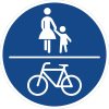
|
|
Signposted foot and bicycle path with dividing line 
|
Footways
This abstract describes all elements, where pedestrians get access to public transport. To use OSM-Data for routing, the modeling from a footway/ street to a platform would be the best solution. Elevators, ramps and escalators should enable a wheelchair accessible routing. Therefore the main emphasis should be put in these.
Footways 
Footways along street edges, which are leading to public transport, are captured with highway=footway. If there aren't existing any footways they have to be created. If a footway is created along a street edge, the edge gets the tag foot=use_sidepath. See the abstract "Street".
| Image/Descritpion | Tags |
|---|---|
signposted footway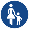
|
highway=footway
If the footway isn't signposted (e.g. pavements), the tag highway=footway is used with the combination of footway=sidewalk + name=*. The combination of these tags enables renderers, that the names don't appear on the map. The mapping of pavements makes the wheelchair routing easier, because additional information (e.g. height of the pavement: height=* or wheelchair accessible information for the pavement wheelchair=*) can be added. |
Signposted foot and bicycle way
|
|
Signposted foot and bicycle way with dividing line 
|
<map lat=" 48.1285929" lon="11.6045866" z="17" w="400" h="250" format="jpeg" />
Pedestrian zone 

For pedestrian zone and other areas with a concrete ground (for pedestrians), the tags highway=pedestrian,area=yes are used. Areas with names are additionally captured with name=*.
When a pedestrian zone consists of "holes" (e.g. accesses to subway or light rail), the outer polygon (pedestrian zone) and the inner polygon (access) are mapped seperately. Both are put in a relation type type=multipolygon.
If the polygons are already created but aren't in relation, the tag area=yes has to be added.
Examples are railway stations Prinzregentenplatz, Isartor and Karlsplatz (Image).
Tactile paving 

With the tag tactile_paving=yes important objects for blind people are identified. These objects are mostly captured at the station environment. The tag on points (nodes) has a different meaning than on ways:
On a point (node) ![]() the tag tactile_paving=yes is used when a footway is ending with an lowered curb at crossroads. Both footway sides are captured seperately.
the tag tactile_paving=yes is used when a footway is ending with an lowered curb at crossroads. Both footway sides are captured seperately.
A way ![]() with tactile_paving=yes is a tactile strip. The tag can also be added to footways/ platforms, which means that the whole way/ platform has tactile paving.
with tactile_paving=yes is a tactile strip. The tag can also be added to footways/ platforms, which means that the whole way/ platform has tactile paving.
Crossings 
The tags are being placed on the position, where two edges clash each other.
Crossing street and footway
| Name and description of crossing | Tags | UK short names | Image
|
|---|---|---|---|
| Zebra crossing
A footway crossing without traffic lights which has white strips on the street. In the dark it is mostly lighted in yellow. |
highway=crossing
crossing=uncontrolled |
crossing=zebra | 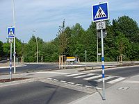
|
| Pelican crossing ('traditional' designation in the UK) Traffic lights which are only designed for pedestrians (can be button operated (button_operated=*) or not). |
highway=crossing
crossing=traffic_signals Traffic lights, which are directing the traffic (pedestrians, cars etc.). traffic_signals:sound=yes Pedestrian traffic signals (Pelican/Toucan/Pegasus) with sound for the visually impaired. traffic_signals:vibration=yes Pedestrian traffic signals (Pelican/Toucan/Pegasus) with vibration for the visually impaired. |
crossing=pelican |  
|
| 'Toucan' crossing ('traditional' designation in the UK) Traffic lights which are designed for pedestrians and bicycle riders (can be button operated (button_operated=*) or not). |
highway=crossing
crossing=traffic_signals Traffic lights, which are directing the traffic (pedestrians, cars etc.). segregated=no Indicating, that the crossing for pedestrians and bicycle riders is combined. segregated=yes indicates, that pedestrians and bicycle riders have seperate ways on the crossing. traffic_signals:sound=yes Pedestrian traffic signals (Pelican/Toucan/Pegasus) with sound for the visually impaired. traffic_signals:vibration=yes Pedestrian traffic signals (Pelican/Toucan/Pegasus) with vibration for the visually impaired. |
crossing=toucan | 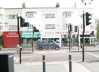
|
| Pedestrian crossing without traffic lights. | highway=crossing | ||
| Crossing with traffic island. | highway=crossing
crossing=island;uncontrolled (or |

|
Crossing rail and footway
| Name and description of the crossing | Tags |
|---|---|
| Rail crossing from a pedestrian | railway=crossing
crossing=uncontrolled crossing:light=yes/no with traffic lights |
Crossing rail and street
| Name and description of the crossing | Tags |
|---|---|
| Crossing rail and street | railway=level_crossing |
Crossing rail and rail
| Name and description of the crossing | Tags |
|---|---|
| Crossing rail and rail. Used when two rails cross each other but can't change their own track. | railway=railway_crossing |


