Tag:highway=trunk
| Description |
|---|
| Important roads that are not motorways. |
| Rendering in OSM Carto |

|
| Group: highways |
| Used on these elements |
| Implies |
| Useful combination |
|
| See also |
| Status: de facto |
| Tools for this tag |
|
Use highway=trunk for high-performance or high-importance roads that don't meet the requirements for motorway, but are not classified as highway=primary either (subject to country-specific exceptions listed below). In different countries, either performance or importance is used as the defining criterion for trunk – see #International equivalence and Highway:International equivalence for guidance on road classification in different countries.
How to map
To map a simple trunk road you can just draw a line for it. Select all ways which belong to the trunk road and tag them with highway=trunk. As always, use oneway=yes when it is not possible to drive in both directions on the trunk road, and make sure the way points in the same direction as the oneway goes.
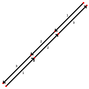
In the case of a dual carriageway you should draw one way for each direction and tag each direction separately. Position the nodes in alignment (as shown), this gives a better result when the map will be rendered and indicates directly that both ways belong together.
To attach more information for the trunk road you should add further keys.
- maxspeed=Number indicates the maximum speed which is allowed
- minspeed=Number indicates the minimum speed which need to be reached to use this road
- name=Name of the road
- ref=reference name e.g. "B 6", see your countries road identification system
- int_ref=* International reference number E.g. E 12
- lanes=Number to indicate how many lanes exist on the trunk road.
- motorroad=* indicates if this road has the motorcars only traffic rule
- expressway=* indicates if this road is an expressway: a dual-carriageway (divided) highway with high-speed design features, plus limited access to adjacent properties or grade-separated interchanges.
- toll:N3=yes - Tolls for trucks with a maximum permissible weight> 12 t
- destination=* Indicates where the road goes to. Consider the direction of the way and use the name of the city written on the sign which belongs to the trunk_link: for example "London" (for trunk_link see highway=trunk_link)
Special situations
In the case you do not have a normal trunk road you should take a look on these sites:
- bridge=yes + layer=1 - If the trunk road goes over a street or waterway.
- tunnel=yes + layer=-1 - If the trunk road goes below a street or waterway.
International equivalence
Below is a comparison of how some of the tags are assigned in different countries. Users should consult the guide for the particular country for more details and additional tags.
See Category:Projects for country specific projects and Tagging for list of country specific tagging guides.
| Country | Trunk description | More details |
|---|---|---|
| National highways; state strategic road network. | Australian Tagging Guidelines/Roads | |
| Autostraße |
WikiProject Austria/Schnellstraßen | |
| In general, roads with an F9 traffic sign |
||
| Rodovias duplicadas (divided highways), vias expressas urbanas (urban expressways) | ||
| Скоростен път с поне две ленти във всяка посока. Ограничението на скоростта не трябва да е по-малко от стандартното (50 км/ч за населени места, 90 км/ч извън тях). | ||
| 普通国道 |
||
| Expressways (brza cesta) and motorroads (cesta za promet motornih vozila) |
WikiProject Croatia/Ceste | |
| Silnice pro motorová vozidla: |
||
| Motortrafikvej |
Da:Map Features | |
| Valtatiet/National Highways, "Moottoritiemäiset" tiet/"Motorway-like" roads | Fi:Map Features | |
| Rocade, voie rapide ou voie express. Voie ayant les caractéristiques d'une autoroute. En général, une 2x2 voies avec séparation centrale. Par défaut: lanes="2", maxspeed="110" (sauf périph. Paris: 80) + ref="N xx" ou "D xx" + oneway="yes" + lanes="x" (si voies <> 2) |
FR:Map Features | |
| For Motorway Like Roads (Autobahnähnliche Straße collq. Schnellstraße) without crossings. The carriageways are separated physically or by road markings. Motorway-like junctions with exit signs |
DE:Tag:highway=trunk | |
| 1st-tier National Roads | WikiProject Greece § Road Network | |
| Roads with route number, but not expressways or tunnels | Zh-hant:Hong Kong tagging#街道分類 Classifications of streets | |
| Autóút | ||
| National Roads. Different by island. | ||
| The expressways according to the definition of Iranian National Standardization Organization. | ||
| National Primary Routes, regardless of build quality. Currently numbered N1-N40. Signed in white lettering on a green background. | ||
| National Primary Routes, regardless of build quality. They are numbered with one or two digits. Red numbers on a white background surrounded by green border. |
He:Map Features | |
| "Strade a scorrimento veloce" (~roads for high travel speeds) with on ramps and off ramps and without level crossings or roundabouts, a road class generally between primary roads and motorways. For mapping access restrictions similar to motorways, use the tag motorroad=yes. Usually the major roads between cities are of this type. | IT:Tag:highway=trunk | |
| 国道/National Highways | ||
| Rocade, expressway. 2×2 divided highway, every intersections with roundabout. Speed limit varies from 40 to 100 km/h. | ||
Requirements:
|
ES:Mexico/Red Nacional de Caminos#Troncales (highway=trunk) | |
| NL:The Netherlands roads tagging#Auto(snel)wegen | ||
|
Strategic State Highways |
||
| Nation infrastructure road (Riksvei) that are not "Motorvei" , green signs, include E-roads class A and B |
No:Map Features#Road classes | |
|
Philippines/Mapping conventions/Roads | |
| Some (e.g. single-carriageway) droga ekspresowa Note that most (~95%) of droga ekspresowa roads in Poland are good enough to be tagged as highway=motorway – high-speed, limited-access highway with similar restrictions as in case of motorways (no bikes/horses/tractors allowed), but a bit lower technical parameters (e.g. lower speed limit 140 km/h for autostrada vs. 120/100 km/h for dual/single carriageway droga ekspresowa).
highway=trunk is applied to those small portion of droga ekspresowa roads that do not fulfil highway=motorway requirements, since some of them still can be single carriageway. They are also allowed to have at-grade intersections in exceptional cases, but since 2020 no such intersections exist.[1][2][3]
Reference numbers for expressways in Poland have 'S' prefix, for example S5 |
WikiProject Poland/Klasyfikacja dróg | |
| Portugal's highways standardization | ||
highway=trunk is used for any national road part of a European corridor or express ways (do not exist in Romania); along with the national road shield (white on red background) E.g.: DN6/E60, DN2/E85 . |
Ro:Map Features#Drumuri | |
| Motorroads (Мотопут/Motoput) |
||
| Cesta pre motorové vozidlá: |
||
|
Divided highway without ramps. |
||
| Trunk roads (stamväg) as defined by the state, including all European routes and certain other national roads (riksväg). See Lista över stamvägar i Sverige. | ||
| Autostrasse / autoroute de 2eme classe (semi-autoroute) | ||
| Refers to a (paved) 'Trunk Road', as classified by Tanroads. Main roads that connect major cities in the country: e.g. T1 from Dar es Salaam - Zambia border. | ||
| WikiProject_Thailand#Intercity | ||
| Divided Turkish State Highways (devlet yolları) such as D.100 | ||
| Primary A road (green signs) | ||
As the top non-motorway classification, highway=trunk should be applied in the following cases:
Historically, trunk in the US has been defined based on physical construction, but the 2021 US highway classification project has moved to a definition based on network importance. |
United States/2021 Highway Classification Guidance#Trunk | |
| National roads network that cross the entire country connecting the most important cities. |
| |
| Trunk (Xa lộ) in Vietnam usually have more than 3 lane with lane classification signs. |
Examples
Note that highway=trunk is classified by its importance in road network, not by its quality (though in given area these two will correlate extremely strongly).
In one place multilane double carriageway can be highway=primary or lower - and in another part of the world, with poor road quality highway=trunk may be single lane road surfaced with gravel.
| Picture/Description | Tags |
|---|---|
| highway=trunk name=Ethan Allen Highway lanes=2 maxspeed=50 mph} surface=asphalt ref=US 7 bicycle=yes foot=yes | |

|
(for each carriageway) |
See also
References
| ||||||||||||||||||||||||||||||


